
Happy Halloween 2021
Posts
Weekend Fun: Uncontented Cows??

Do these cows look "miserable" to you? They are grazing in the Kansas Flint Hills Since these wackos got the publicity (which is what they want), let's have a little fun with this. PETA explained its stance in a news release Thursday ... saying "bullpen" is insensitive to cows. The org. said baseball should instead use "arm barn" to avoid the issue. "Words matter, and baseball 'bullpens' devalue talented players and mock the misery of sensitive animals," PETA exec Tracy Reiman said. My granddaughters look toward the Wichita Wind Surges' bullpen in left field I wonder how PETA came up with "Arm Barn"? Here are my suggestions if baseball really wants to rename the bullpens: Pitchers' Patch Curveball Cubbyhole Baseball Bunch Hanging Curveball Hangout However, given PETA's perennial lack of a sense of humor, I would have thought they would have proposed "Arm Pit" over Arm Barn. After all, in their w...
For Christmas Gifts
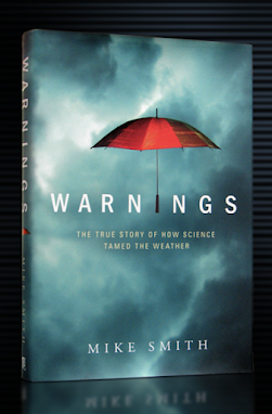
Thanks for all of the great sales! However, Wednesday, I received this updated notification from Greenleaf Book Group, the publisher of Warnings: The True Story of How Science Tamed the Weather : It should also be noted that large organizations like Amazon and Ingram have already announced to the publishers that there will be delays in their order processing and inventory receivings. What this means is that with the increased demand during Q4, we could potentially see out of stocks on Amazon or B&N. Right now, it is taking longer than normal to process incoming deliveries, which is causing delays in books being received in inventory. Please be patient during this time. Add that to the Postal Service's announcement they are intentionally slowing the mail , things could get ugly if you wait to order books for Christmas. We just added to the supply of Warnings in the warehouse in anticipation of all of these issues. Stil...
Review of "Don't Blow Yourself Up"
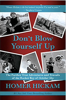
When the movie October Sky was released in 1999, I couldn't wait to see it. It is the autobiographical story of Homer Hickam, Jr and his friends building rockets in a small West Virginia coal town (Coalwood, to be exact). As a "science geek" in junior and high school (meteorology and, yes, two friends and I built rockets one summer), I certainly empathized with the story. October Sky exceeded all of my expectations; so much so that I later read and loved the book upon which it is based, Rocket Boys (The reason the movie had a different name is because there was a low-budget movie about Elton John in process. The the producers of Sky thought there may be confusion). I loved the book, too. At the end of the movie, it is revealed that Homer became an engineer for NASA training astronauts. Homer also became a prolific best-selling author. But, there was a hole in Homer's story: what happened in his life after high school? Now, we know the answers. They ar...
Mobile Homes MUST Be Evacuated Ahead of Tornado Warnings!
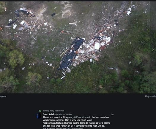
Please note that this piece has been rewritten with regard to the location of the fatality. 10:45am Friday --- This southwest Mississippi mobile home that was obliterated by an EF-1 intensity tornado. Mobile homes, especially if they are not tied down, are unsafe in a tornado. That's why we recommend, when a tornado watch is in effect, that you make arrangements to shelter elsewhere and that you head for the shelter area when thunderstorms move into your region instead of waiting until a tornado warning is issued. This advice would have been especially important yesterday because the tornado warning wasn't issued until just after the mobile home was struck. This was another missed tornado situation by the National Weather Service. Below is the NWS radar data. The upper panel is the Doppler winds. There were two small tornadoes (circled); known as QLCS tornadoes as they were embedded in a squall line. The bottom panel shows both were in contact with the groun...
Rare Agreement: President Biden and I
I have no way to know how much racism is, or is not, in the federal government. But, one way to get less racism is to cut the federal government by two-thirds. And, disperse the remainder (e.g., Agriculture to Wichita, Transportation to Chicago, etc.). Make the federal government smaller, more focused, and more accountable. That's something I can get behind!
Additional Tornado Watch for Louisiana and Southern Louisiana
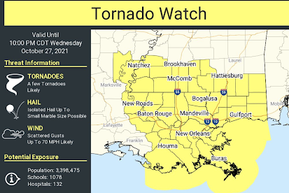
This tornado watch includes, for example, New Orleans, Baton Rouge and Hattiesburg. Weather conditions continue to be favorable for generating tornadoes. Please monitor local media for updated warnings and other information.
Destructive Tornadoes in Southeast Texas

The white and blue areas were where tornadoes moved across the area at of 10:30am. The red-yellow colors may have experienced a tornado. These areas are east of Beaumont in the far southeast part of Texas. There is spectacular video here , here , and here . At 10:40am, tornado watches covered the areas in pink till 4pm. The red = tornado warning; yellow = severe thunderstorm warning.
Tornado Watch: Texas and Louisiana

Strong tornadoes are forecasted to occur. The watch is in effect until 4pm.
Updated Tornado Forecast for the Great Plains
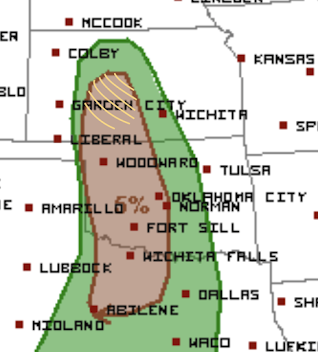
The brown area has a significant risk of a couple of tornadoes. The hatched area is where I think the chances are highest but my confidence is not very high. Any significant storms will be 6pm or after.
Tornado Forecast For the Great Plains

The brown area has a significant risk of a couple of tornadoes after 5pm this afternoon until around 1am. Right now, this is a low confidence forecast. So, I will likely update again late this afternoon.
Meteorologists: Promote the Value of What We Do!

St Louis Post-Dispatch Violent tornadoes occurred in the Mississippi Valley last night. For a terrifying video of a huge tornado approaching at night, click here . There were at least four paths of what appear to be major tornadoes across southeast Missouri and southwest Illinois. And, those tornadoes occurred in darkness, which usually makes them more deadly. But, at least at this point. Things are looking good. As far as I can tell, the warnings were excellent. For that the NWS in St. Louis and the STL broadcast meteorologists deserve credit. The St. Louis Post-Dispatch published this comment: Post-Dispatch I appreciate Alex's comment, but I think there is something missing, which might be highlighted by the Twitter comment below. "We can't devise an early warning system for tornadoes?" What does she think all of the information below was? All of the television coverage? The sirens going off? As I discuss in Warnings: The True Story of How Science Tamed the Weat...
The Insanity of COP26, The Global Warming Meeting
Billions spent on wind turbines that rarely generate electricity in a reliable manner. The website Issues & Insights has an insightful piece on the international global warming meeting starting in Scotland. It is titled: Perfect. The vast majority of the attendees are second level-politicians who go to hobnob with other second-level politicians. The United Nations Conference of Parties on climate change, the 26th version of this long-running clown show, starts Oct. 31 and will run through Nov. 12. Media coverage will be both intense and obsequious; attendees, especially the ever-smug John Kerry, “special” climate envoy to the president, will speak in somber tones due to the seriousness at hand; warnings of impending doom will be issued; and absolutely nothing will be accomplished. Correction: nothing useful or positive will be accomplished. They will spend huge amounts of our taxpayer money and find ways to diminish our freedom. For example, past meet...
Paths of Strong Tornadoes in SE Missouri and S Illinois

This is a map of the paths of strong tornadoes that occurred in southeast Missouri and across the river into Illinois. These tracks are not a one-to-one correspondence to tornado paths but where you see while and blue it is nearly certain a tornado was present (click to enlarge). This map is as of 10pm CDT. This will be the last update of the night.
Tornado Watch in Effect for Missouri and western Illinois

NWS has issued a tornado watch for parts of Missouri and west central Illinois until 10pm. Please follow me on Twitter @usweatherexpert . I'm providing updates there. Please also monitor your local source of storm warnings. Note: at 2:08p, a potentially dangerous thunderstorm is about 10 mi west of St. Joseph, moving NE, that is outside the watch.
Updated Tornado Forecast

Here is my updated tornado forecast for 1:15 pm this afternoon until 4am Monday. Keep in mind that my system uses the following risk levels: Slight Enhanced High Extreme My system doesn't just account for meteorological risk but also whether the tornadoes are expected to occur in daylight or after dark. I will update again early this evening. If you live in these areas, please keep up on the weather and you may also follow my updates on Twitter @usweatherexpert .

Today's Tornado Risk

There are two levels of risk: The yellow area is an elevated risk of tornadoes. Where it is hatched, there is a risk of strong tornadoes. This includes St. Louis, Quincy, Columbia, Joplin, Lake of the Ozarks, Branson, Table Rock Lake, Fayetteville, and both Springfields. The brown area is a significant risk of tornadoes. This includes Kansas City, MO; Peoria, Cape Gireadau, Little Rock, Paducah and Ft. Smith. Please pay attention to local weather warnings in these areas. I will update this afternoon.
Forecasted Rainfall Amounts for Next Week

Every state of the lower 48 will receive significant rain. West of the Continental Divide the easing of the drought will continue. Flooding rains are quite possible in both New England and California. In a number of areas, the 2021 fall harvest will be delayed. This week's rainfall to 7am is below. If the current pattern holds, the drought in the West will be significantly improved in ten days. The forecasted rains will also make sure that 2022 winter wheat crop east of U.S. 83 will be off to a good start.
Heads Up: United States East of Rockies!!

From tonight through Thursday, there is the likelihood of severe thunderstorms with some accompanied by tornadoes in a strong than average autumn severe weather period. Tonight Tonight, the only real threat is hail in the Lower Missouri River Valley. Note: in the unlikely event a strong thunderstorm develops in south central Kansas, it would have significant tornado potential. But, the atmosphere is too "capped" and I don't think thunderstorms will develop. Sunday This is important . Missouri and the Arkansas Ozarks in the hatched area an elevated risk of tornadoes, some could be strong. This includes Columbia, St. Louis, the Lake of the Ozarks, Brandon, Table Rock Lake and Fayetteville. While I will update on this threat tomorrow tomorrow morning, it is essential to make sure your shelter area is ready today. The brown area has a significant ris k of tornadoes This includes Tulsa, Little Rock, Cape Giradeau, Quincy and Ft. Smith. Monday The weather system...
Another Global Warming Story That Is a Huge Exaggeration

The Weather Channel is telling us that some roads in Monroe County, Florida, which is the Florida Keys, will be "underwater" in five years . And, fixing 'the threat' comes at a "staggeringly high cost." The story, typical for global warming alarmism stories, did not cite any science or databases. So, I did the work The Weather Channel should have done. The gold standard for sea level measurements is the University of Colorado. According to its data (above), sea level will rise 1/2" over the next five years (till 2025, as stated in the story) and 1.1 inches between now and 2031. A half-inch sea level rise will not put any road in Florida "underwater." I've never understood why The Weather Channel has adopted extreme global warming alarmist positions. Between that and running shows about truckers during tornado outbreaks and NYC floods, I can't find much of a reason to watch anymore.
He Runs on Wind Energy and It Was Calm Outside

From this evening's CNN downhill Town Hall [stupid spell check].
A Note to Blog Readers - Long Range Forecasts
There's been a lot of news today about NOAA releasing its winter outlook. You will not see it on this blog, nor will you see AccuWeather's, the Weather Channel's, nor the others. I do have respect for Joe Bastardi's outlook (updated here ), but even then I would urge caution.
Stock Photography of the Supply Chain Crisis

As the supply chain crisis deepens across the nation, I have photography that may help with associated news coverage. You'll find a number of photos related to logistics and supply chains at my ShutterStock collection . You will also find my weather photography at Adobe Stock photography . BTW: There will be considerable storminess this weekend and it will be covered in this blog.
And, Fidel, Pol Pot, Et Cetera...

Is it occurring to anyone that, the closer we get to socialism, the empty shelves -- a trademark of socialism -- get more common?