Tuesday, February 28, 2023

Note to Readers...

Over the next few days we have the potential for:
  • Tornadoes and damaging winds in the South.
  • Flooding rains in the Ohio Valley.
  • Snow in the Great Plains
  • Another snow and rain event, possibly major in California and the Southwest
So, I am going to suspect non-forecast content for the next two days. I urge you to follow along if you live in any of these areas. 

February Precipitation

This is the total precipitation for the 30-days ending at 7am this morning. We are emphasizing the winter wheat zone because of the worldwide shortage. 

Below is the difference from average precipitation (rain and melted down snow). Unfortunately, the yellow is where the drought got even worse. In areas where it is the background color, things stayed the same -- which is unfortunate because the area was already quite dry. 
Keeping in mind that winter wheat is planted in September and harvested from late May to July, in Kansas, many areas have wheat rated poor or very poor. The worst problem, by far, is drought. 

China Isn't Stupid About Energy Like We Are

From Jo Nova:
China has committed to renewals for public relations reasons, only. They are building as many as two coal plants per week to provide electricity for their population. They are not pretending that renewables are valuable in and of their own. Yes, we should decarbonizing energy but we should do it through nuclear and hydro, not unreliable wind and solar. 

StormWarn Success Story!

We've developed StormWarn because we believe it is the best way to warn of dangerous storms: 
  • You can a call on up to two phones if a tornado warning or winds of 80 mph or stronger are approaching the location you select. Get to shelter instantly. No need to think about it as you are notified only if you are in the path. 
  • Otherwise, we leave you alone!
The second point is more important than you might think. 

There is a StormWarn customer in Bloomington, Kansas. Sunday evening, a tornado warning was issued for an area that was as close as four miles away. There was damage to a home near Augusta. It had part of its roof rolled back, so the small tornado warning was valid as there was genuine danger. 
But, in Bloomington, there was no threat. And, her phone didn't ring. Before you say, "Big deal," please consider: several people in her home were sick with the flu. And, her 92-yr old father is living with them and she only wants him to climb down the basement stairs if it is an emergency. The prevention of a false alarm was of signifiant value.

With StormWarn, you get a notice only if you need to take action at your location. The $25 for a year of 24/7/365 protection is a great value. It is a system I believe in because useless alarms are not going off for 1" hail, weekly tests, and other non-action conditions. 

Finally, I receive no money from them. I promote it because I believe it is a great way to save lives. 

Monday, February 27, 2023

How Did Yesterday's Tornado and Damaging Wind Forecast Work Out?

Let's start with the wind forecast. I agreed with the NWS SPC's forecast so that is what I posted yesterday afternoon.

While more reports will come in over the next day or two, I wanted to post something while this event was fresh in everyone's minds. 
The colors represent the forecast density of reports. The blue dots represent wind reports of 60 to 74 mph. 

Hatching was the indication of the forecast of wind gusts of 75 mph or more. The black squares represent actual wind gusts of 75 mph or stronger. The peak gusts, measured at official weather stations, were 114 mph at Wheeler, TX (in the hatching) and 97 mph at the Hodgeman Co., KS station (not in the hatching).

The preliminary grade I would give this is B+. It is a bit of an over-forecast of 75+mph gusts. 

Tornado Forecast
I created my own tornado forecast for the blog yesterday which is the one we will grade here. 

A brown T is a tornado. All of the current NWS tornado locations are on the map. There are T's that are not on the NWS's current list. Those were derived by storm chaser video or a report that appeared correct from radar. The Tf1 denotes the one tornado-caused fatality at Cheyenne, OK. Note the T for Tulsa is not a tornado. 

We have a problem because some possible tornado locations will evidently not be surveyed. Those are denoted by a "?". For example, the ? near Tonkawa was based on rotation on radar and I-35 being closed due to transmission lines (the one on the tall metal poles) across the highway. 

With the exception of the tornado just west southwest of Dodge City, all of the reports are within the forecast. There appears to be a greater density of reports in the Enhanced Risk (red) than in the Significant Risk (orange). If all of the ?'s are genuine tornadoes, then I would rate this forecast an A-. The "-" is because of the relatively few reports in the eastern part of the "Significant" area, meaning that part of the forecast was too geographically large. Addition: Based on Reed Timmer's video, I have added a T in Wheeler County, TX. 2nd addition, I have added two T's based on info from KWTV's tornado reports. As of 6pm, we got a report of two tornadoes in Dade County of southwest Missouri, which are now on the map. At 8:30pm, I became aware of another tornado in SW Missouri which is right on the edge of the Significant area. Fortunately, the southwest Missouri tornadoes were relatively weak. 

If I get information that materially impacts the evaluation of these forecasts, then I will update and repost. 

The most important thing is that this was a significant weather event for which the forecasts were quite good. It is important that these events be well forecasted and this was. 

Today's Tornado Risk

The brown area has a significant risk of tornadoes into this evening. 
There has already been a tornado near Champaign, Illinois.     

Why You Shouldn't Be Frightened By Climate Doom Forecasts

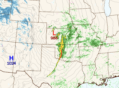
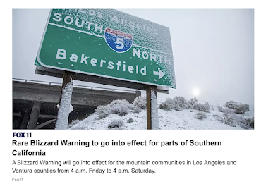
How is the environmental movement's record on forecasting? I recently saw a summary:

... warnings that the oceans would be “As dead as Lake Erie by 1980” (Ehrlich, 1970), that there would be a new Ice Age in 10 years (NASA, 1971), that England would cease to exist by 2000 (Ehrlich, 1971), that there was “no end in sight of the cooling trend” (New York Times, 1978), that the Maldives would be “completely underwater in 30 years (1989), that UK snowfalls were a thing of the past (University of East Anglia, 2000), that Britain would be “Siberian” by 2025 (Pentagon, 2004), that the Arctic would be ice free by 2013/2014/2016/2018 (Gore, US Navy, NASA), etc.

In other words, all of the "tipping points" and other scare tactics not only lack scientific validity, it is worse than that. They are a product of Big Climate's rapacious appetite for money and power. 

Sunday, February 26, 2023

Wrapping Up Storm Coverage As of 11pm

As of 10:45pm, red dots are confirmed tornadoes. There were many tornadoes, some that did significant damage, in Oklahoma that are not yet on the map. One of those struck southeast Norman but missed the OU campus. 
The blue dots are thunderstorm-generated winds of 58 mph or stronger. The strongest has been a gust of 114 mph clocked at the Wheeler, TX weather station. 

In addition, here is a very preliminary map of tornado touchdowns in Oklahoma. 

I-35 at Tonkawa, OK is closed due to power lines across the highway.

As for power outages, so far about 100,000 homes and businesses are without power in Oklahoma, north Texas and New Mexico.

Below is where the great number of power failures in Oklahoma have occurred. 

There are also 1,500+ homes and businesses without power in Sumner and Cowley counties of Kansas. 

As of this time, the lines of thunderstorms continue to move east. 
Reds are areas of high winds as of 10:55pm. 

For Meteorologists
Be sure and look at this OUN tornado proximity sounding. It was taken 15-20 minutes before the tornado arrived almost on top of the launch site. Note the inversion. The strong dynamics blew it out and combined with 1,000+ 0-1km SRH to produce what (very preliminarily) looks like an EF-2 tornado in southeast Norman. 

Here is the ROC/NSSL -88D (located on North Campus of OU) depicting the tornado as is was just south of the launch site. This was 9:21pm.

Derecho and Tornado Forecast: Now Until 7am Monday

I am so concerned about this situation because there will be widespread power failures in Oklahoma and, perhaps, into far south Kansas and into the Ozarks. Because of the power failures still be repaired in Michigan and California, crews will be short to make repairs from this storm. That means some people may be without power for more than 24 hours. 

It is essential that preparations be made now! See below.

Storm Timing
Here is a rough idea of when the strongest storms will occur in a given area. 
It is possible that damaging wind gusts could reach as far east as St. Louis by 7am.

Derecho Threat
Wind gusts 100 mph or stronger are forecast to occur in the purple/hatched area. Wind gusts of 75 mph or more are forecast to occur in the red area. In both areas, power failures will occur on at least a scattered basis! You'll will find preparation suggestions below. 

In the yellow area, there will be wind gusts to 60, possibly, 65 mph. Since the leaves are not yet on the trees, I would expect any power failures to be relatively small in area.

Tornado Threat
Above is my tornado threat area. As we've discussed the past few days, any tornadoes will have forward speeds of 50-60 mph. More than ever, if a tornado warning is issued for your area take cover and don't go outside to look!

NWS Storm Prediction Center says they are going to position an initial tornado watch in this area. 

Preparation Suggestions
Make sure you have at least two independent sources of storm warnings! The forward motion of these storms will be 50-60mph, so if tornado warning or a warning of winds 80 mph or stronger is issued, there will be no time to lose -- get to shelter immediately.

Because the threat will continue after dark, I recommend StormWarn. It will call you if your home is in the path of a tornado or damaging winds (≥80 mph) for just $25/year. I make no money from your subscription; but I helped design it and believe in it. It allows you to retire for the night knowing that if the NWS issues a warning for dangerous conditions, you will receive via phone. 

I also recommend activating the FCC's Wireless Emergency Alerts (WEA) on your smartphone. If you have an iPhone, go to "Notifications" and scroll down. Below is the way to get storm warnings and very little else (the way I want it).
Another good source is the AccuWeather App, which tracks your position and gives you warnings based on your current location. It is free, but there are advertisements. Take your smartphone to bed with you and remember to turn off "Do Not Disturb" tonight. 

Once you have your warnings communications set up:
  • Charge your cell phones and laptops but take them off the chargers before the storms arrive. Power surges as the storms move through can damage those devices. 
  • If you have infirm friends or relatives, make provisions for them when a tornado or severe thunderstorm watch is issued. The storms will be far too fast for you to drive somewhere when a warning is issued. 
  • If you are in the areas with a relatively high risk of power failures, make sure your auto is fueled, that you have plenty of cash, and if you have medicines that require refrigeration, that you have a way to make sure they stay cold. 
Now that the first storms have begun to form, most of my coverage will move to Twitter @usweatherexpert. I will have a brief update on the blog this evening. 

High Risk of Damaging Winds and Tornadoes Between 2pm This Afternoon and 5am Monday

UPDATED FORECASTS IMMEDIATELY ABOVE. PLEASE SCROLL UP. 

Please prepare for a major wind event and, in some areas, tornadoes.

Tornado Risk
Above is my forecast for tornado risk from 4pm to 2am. 

Damaging Wind Threat
This updated forecast takes the potential for gusts in excess of 60 mph past the Lake of the Ozarks all the way to St. Louis and Hannibal. The extreme risk area is extended to Vinita, Oklahoma and into the far southern Flint Hills of Kansas. 

This damaging wind event -- with wind gusts stronger than 90 mph possible -- is nearly certain to occur late this afternoon into tonight. The SPC is now forecasting wind gusts to 110 mph. 

Let's break it down, using my system of risk communication. 
  • Purple = extreme risk of damaging winds. Gusts well above 75 mph are likely with power failures. 
  • Red = high risk of damaging winds. Gusts above 75 mph are possible as are power failures.
  • Yellow with hatching (Texas) = enhanced risk of wind gusts of 60 mph or stronger.
  • Yellow = significant risk of wind gusts of 60 mph or stronger.
I urge you to prepare. Given that we are moving into "tornado season..."

Make sure you have at least two independent sources of storm warnings! The forward motion of these storms will be 50-60mph, so if tornado warning or a warning of winds 80 mph or stronger is issued, there will be no time to lose -- get to shelter immediately.

Because the threat will continue after dark, I recommend StormWarn. It will call you if your home is in the path of a tornado or damaging winds (≥80 mph) for just $25/year. I make no money from your subscription; but I helped design it and believe in it. It allows you to retire for the night knowing that if the NWS issues a warning for dangerous conditions, you will receive via phone. 

I also recommend activating the FCC's Wireless Emergency Alerts (WEA) on your smartphone. If you have an iPhone, go to "Notifications" and scroll down. Below is the way to get storm warnings and very little else (the way I want it).
Another good source is the AccuWeather App, which tracks your position and gives you warnings based on your current location. It is free, but there are advertisements. 

Once you have your warnings set up:
  • Charge your cell phones and laptops but take them off the chargers before the storms arrive. Power surges as the storms move through can damage those devices. 
  • If you have infirm friends or relatives, make provisions for them when a tornado or severe thunderstorm watch is issued. The storms will be far too fast for you to drive somewhere when a warning is issued. 
  • If you are in the areas with a relatively high risk of power failures, make sure your auto is fueled, that you have plenty of cash, and if you have medicines that require refrigeration, that you have a way to make sure they stay cold. 
Please pay attention to the weather starting this afternoon. 

Sunday Fun

Saturday, February 25, 2023

Fast-Moving Midwest Storm


Forecast for 8pm Sunday
PolarWx
There will be very high winds of more than 70 mph in west Texas Sunday afternoon. The squall line in Oklahoma and, possibly in Kansas, is forecasted to produce damaging winds of more than 80 mph along with tornadoes. 

8am Monday
The purple is freezing rain. It will likely accumulate sufficiently to cause power failures. See additional info at the purple link above. High winds will accompany the low from the Dakotas to the Ozarks as well as around the Great Lakes.

6pm Monday
The rain will change to snow in western Ontario, Upper Michigan and Wisconsin. The freezing rain will move from the thumb of Lower Michigan into Pennsylvania. High winds will gradually move east. Where the light brown lines (isobars) are close together, high winds are likely. 

Another Ice Storm Threat for Wisconsin and Michigan

Another period of freezing rain, along with potential power failures, is in store for Wisconsin and Michigan. 

As of 5pm EST, there are still 393,000+ homes and businesses are still without power. 

This was very well predicted by the Sperry-Piltz Ice Accumulation Index. An excerpt of one of the forecasts that appeared on this blog before the storm is below. Note the prediction of major power outages.

The index is usually quite accurate. 

Unfortunately, we have a new ice storm risk for Wisconsin and Michigan. Below are the detailed maps.
Freezing rain will likely develop in Wisconsin after 1am on Monday. 

Freezing rain will likely develop after 6am Monday in Michigan. 

The details of the index are below. Click to enlarge. 
Utility crews will be strained to restore power if this develops as forecasted. Electrical outages, as a result, may last longer than usual. 

Tornado and Damaging Wind Outlook: 2pm Sunday to 3am Monday

-- UPDATED FORECAST ABOVE --

Tornado Forecast
nadocast.com
The yellow area has an enhanced risk of tornadoes, especially in the late afternoon and into the early evening. The brown areas have a significant risk of tornadoes that will last into the evening (darkness). These tornadoes will be difficult, if not impossible, to see coming. So, if a tornado warning is issued do not go outside trying to see the storm. The bright green area is where I would say, "I can't rule out a tornado" but I don't think the chances require special preparation. 

Damaging Wind Forecast
In my 4-category risk communication system...
  • Purple has an extreme risk of damaging winds, with gusts stronger than 75 mph. Power failures are quite likely. 
  • Red has a high risk of damaging winds with gusts stronger than 75 mph. Note: This is based on the Storm Prediction Center's forecast. I do believe the "red" risk should be taken an additional 1-2 counties farther north in Kansas. Power failures are possible. 
  • The yellow area in southwest Missouri and northwest Arkansas (hatching) has an enhanced risk of thunderstorm wind gusts stronger than 60 mph.
  • The unhatched yellow area has a significant risk of gusts above 60 mph. 

Advice For People in the Forecast Path

Given that we are moving into "tornado season..."

Make sure you have at least two independent sources of storm warnings! The forward motion of these storms will be 50-60mph, so if tornado warning or a warning of winds 80 mph or stronger is issued, there will be no time to lose -- get to shelter immediately.

Because the threat will continue after dark, I recommend StormWarn. It will call you if your home is in the path of a tornado or damaging winds (≥80 mph) for just $25/year. I make no money from your subscription; but I helped design it and believe in it. It allows you to retire for the night knowing that if the NWS issues a warning for dangerous conditions, you will receive via phone. 

I also recommend activating the FCC's Wireless Emergency Alerts (WEA) on your smartphone. If you have an iPhone, go to "Notifications" and scroll down. Below is the way to get storm warnings and very little else (the way I want it).
Another good source is the AccuWeather App, which tracks your position and gives you warnings based on your current location. It is free, but there are advertisements. 

Once you have your warnings set up:
  • If you have infirm friends or relatives, make provisions for them when a tornado or severe thunderstorm watch is issued. The storms will be far to fast for you to drive somewhere when a warning is issued. 
  • If you are in the areas with a relatively high risk of power failures, make sure your auto is fueled, that you have plenty of cash, and if you have medicines that require refrigeration, that you have a way to make sure they stay cold. 


Discussion for Meteorologists of Sunday's Threat

This is an unusual early season situation where I am leaning on synoptic climatology to a great deal along with a study I did of conditions that breed nighttime tornadoes. 

A "bomb cyclone" will occur in Kansas with pressures dropping 25 mb in just 12 hours. In the northeast third of the state, there will be an area where (for the public) pressures are forecasted to drop below 29.00 inches. Combined with very high SRH and rising evening temperatures, localized conditions may breed tornadoes along the line or any low-topped supercell ahead of the line. 

The rapid pressure falls, the strong, negatively-tilted short-wave, and strong difluence aloft centered over the northern half of Oklahoma -- when combined with a strong push of dry air from west Texas -- should be enough to generate extreme surface gusts. By early evening 500mb winds into southwest Oklahoma should exceed 120 knots. With the dry air, some of that will mix downward and, when it does, gusts may exceed 80 mph. 

Incredible Rains in Southern California

The map below shows the rainfall for the 3-days ending at 8am PST.
The red dot in the mountains northwest of downtown Los Angeles represents more than ten inches! The yellow is more than four inches. Consider that the average annual rainfall in downtown Los Angeles is a little more than 14 inches. 

Heavy rain, with snow in the mountains (blue shades), continues in San Diego County as of 8:32am.

Looks like downtown Los Angeles will receive an additional half-inch of rain. A little more than that will fall in downtown San Diego. 

"When Thunder Roars Go Indoors"

Daily Mail
The picture on the right shows lightning striking the boy and, at left, the video shows him going under the water. When you hear thunder, go indoors or to your car! The most dangerous places to be during lightning are:
  • Golf course
  • Pool, beach, sailboat
  • Under a tree
  • Open farmland or other open space
It is already thunderstorm season in the South. Thunderstorms will occur in the central Great Plains Sunday. Please remember these suggestions. 

Friday, February 24, 2023

Tornado and Damaging Wind Risk Sunday

This is really a tough forecast but the risk is high enough that I want to bring it to your attention. While it is very early in the season as far north as Kansas, it looks like there will be just enough moisture when combined with the powerful low pressure system coming out of California, we have a risk of tornadoes and damaging thunderstorm winds. 

If this develops approximately as I am predicting, there will be a warning challenge in that the forward motion of the thunderstorms will be 50 to 60 mph toward the northeast. That means the storms are moving a mile each minute. 

Given the storm's fast movement combined with the fact the majority of the storms will be after dark, I highly recommend you spend just $25 to sign up for StormWarn. It will call you, even in the middle of the night, but only if a tornado warning or a warning for winds of 80 mph or stronger are expected for your home's specific location. No being awakened in the middle of night for, say, 1" hail. Click here to sign up. 

BTW: I do not receive any money from StormWarn even though I helped design it and I recorded the warning messages. I believe in this product so that, in a critical situation, you can go sleep at night during a tornado watch knowing you'll be warned in case of a dangerous situation. 

Update on Power Outages

There are still more than 700,000 homes and businesses without power. "Most" are expected to have power restored by Sunday. 

In California, numbers of people without power are rising as the major winter storm moves into the area.  As of 12:24pm PST, here are the storm warnings in effect. 
  • Orange = blizzard warning. 
  • Pink = winter storm warning 
  • Green = flooding likely
  • Blue = winter weather advisory (lesser condition) 
  • Gold = high wind warning 
  • Brown = wind advisory 
  • Deep blue = hard freeze warning.
Please keep tuned to trusted sources of local weather warnings in case evacuations are ordered or other site-specific information. 

It Must Be Rough...

...to fly in a private jet all around the world to five-star resorts to 'fight' global warming.

For the rest of us:
Sierra Club argues that “flying will have to get more expensive” through new taxes on fuel, new charges at airports, and a generalized restriction on supply. The anti-travelers often frame their arguments in terms of “environmental justice,” arguing that air travel is a luxury. If their preferences continue to shape global public policy, it will remain that way, precluding air travel entirely for the 80 percent of human beings who have yet to fly. Few might object to policy shaving off the marginal jaunt from a business executive’s itinerary, but what if that same policy keeps a middle-class American family from visiting grandma, or defers travel for a young Indonesian who wants to see the wider world?

So, as global warming zealots like Kerry, Al Gore, Leo DiCaprio, etc., etc., crisscross the world in their private jets, you and I must not fly to "help the planet." 

As Glenn Reynolds puts it, I'll believe global warming is a crisis when the people telling me it's a crisis start acting like it's a crisis. 

Thursday, February 23, 2023

Update on California Storm Plus Its Effects on the Great Plains

Snow has been falling in Southern California today and it will worsen tonight. For the first time ever the National Weather Service's San Diego office had to issue a blizzard warning. It was for the mountains in Riverside County. 

Here are the latest warnings, et cetera. 
Here are the color codes:
  • Orange = blizzard warning. 
  • Pink = winter storm warning.
  • Green = flood watch.
  • Gold = high wind warning. 
  • Sand = wind advisory.
  • Dark blue = winter weather advisory. 
  • Dark green (one county south of Las Vegas) = winter storm watch
Sacramento may have snow tonight. If so, it would be the first since 1967. 

This powerful storm will move east, thus the winter storm warnings you see in Nevada, Arizona, Utah and Colorado. The National Weather Service's Storm Prediction Center is forecasting unusually early tornadoes -- accompanied by large hail and damaging thunderstorm winds -- over the areas shown below. The forecast is valid from 6am Sunday to 6am Monday. 
The darker area is where the tornadoes are more likely along with the larger hail. 

More tomorrow.

The Forecast for the Blizzard was Excellent

Wyoming roadway this morning; via Twitter

While the blizzard is not over, the (per a friend of mine) complaints are already starting -- almost certainly from people not paying attention -- that "meteorologists are wrong 97% of the time" with regard to the storm. I, too, have seen an upswing of criticisms of meteorologists on social media this week. I don't know why. 

So, to head this off before it goes too far, the blizzard was excellently forecast. 

Here is my forecast (others' were similar) from back on Saturday.
I went out on a limb to make this forecast; I began the forecast sequence a day early because I knew this event would cause so much disruption it was worth taking the chance. Meteorologists do this all of the time. We stake our reputations to provide forecasts that can save lives and mitigate properly loss. 

If you hear criticism about the forecast of the blizzard, please have them contact me. I'd like to hear their concerns. 

Blizzard Warnings and Flood Forecasts for California

Here is the color code:
  • Orange = blizzard warning
  • Gold = high wind warning
  • Green = flood watch
  • Pink = winter storm warning 
  • Deep green = winter storm watch
  • Blue = winter weather advisory
  • Sand = wind advisory
Note that a blizzard warning has been issued for central Nevada. 

It will have been more than 30+ years since a storm of this intensity has affected the Southland. I urge you to prepare accordingly.