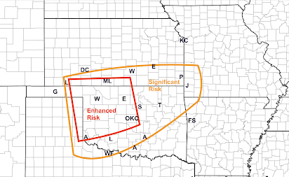
High Risk of Damaging Winds and Tornadoes Between 2pm This Afternoon and 5am Monday
UPDATED FORECASTS IMMEDIATELY ABOVE. PLEASE SCROLL UP.
Tornado Risk
Above is my forecast for tornado risk from 4pm to 2am. Damaging Wind Threat
This updated forecast takes the potential for gusts in excess of 60 mph past the Lake of the Ozarks all the way to St. Louis and Hannibal. The extreme risk area is extended to Vinita, Oklahoma and into the far southern Flint Hills of Kansas. Let's break it down, using my system of risk communication.
- Purple = extreme risk of damaging winds. Gusts well above 75 mph are likely with power failures.
- Red = high risk of damaging winds. Gusts above 75 mph are possible as are power failures.
- Yellow with hatching (Texas) = enhanced risk of wind gusts of 60 mph or stronger.
- Yellow = significant risk of wind gusts of 60 mph or stronger.
I urge you to prepare. Given that we are moving into "tornado season..."
Make sure you have at least two independent sources of storm warnings! The forward motion of these storms will be 50-60mph, so if tornado warning or a warning of winds 80 mph or stronger is issued, there will be no time to lose -- get to shelter immediately.
Because the threat will continue after dark, I recommend StormWarn. It will call you if your home is in the path of a tornado or damaging winds (≥80 mph) for just $25/year. I make no money from your subscription; but I helped design it and believe in it. It allows you to retire for the night knowing that if the NWS issues a warning for dangerous conditions, you will receive via phone.
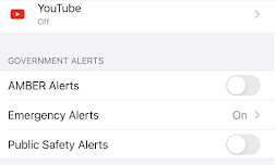
I also recommend activating the FCC's Wireless Emergency Alerts (WEA) on your smartphone. If you have an iPhone, go to "Notifications" and scroll down. Below is the way to get storm warnings and very little else (the way I want it).
Another good source is the AccuWeather App, which tracks your position and gives you warnings based on your current location. It is free, but there are advertisements. Once you have your warnings set up:
- Charge your cell phones and laptops but take them off the chargers before the storms arrive. Power surges as the storms move through can damage those devices.
- If you have infirm friends or relatives, make provisions for them when a tornado or severe thunderstorm watch is issued. The storms will be far too fast for you to drive somewhere when a warning is issued.
- If you are in the areas with a relatively high risk of power failures, make sure your auto is fueled, that you have plenty of cash, and if you have medicines that require refrigeration, that you have a way to make sure they stay cold.
Please pay attention to the weather starting this afternoon.


Comments
Post a Comment