Guess at a Spring Tornado Forecast
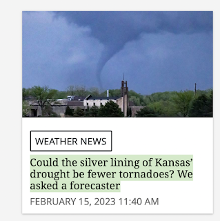
Several newspapers have run stories in the last few days pertaining to what type of tornado season (mild, bad) their readership areas might have this year. As you know, I do not post long-range forecasts on the blog because there seems to be so much interest -- I'm going to offer my thoughts on the topic as it pertains to Kansas as the Wichita Eagle (screen capture above) ran one of those stories.
There are various global warming advocates that, correctly, note the definitions of violent tornadoes have changed over the years. True enough. But, assuming we get to May 20 without an EF-5 tornado, it will have been a full decade since the last occurrence (Moore, Oklahoma).
With the potential of a busy tornado season, I recommend getting your safety area ready to go now. If you need a tornado shelter, go here.
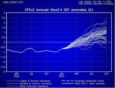
Based on some work I did a few years ago, Kansas tends to get more and worse tornadoes when El Nino/La Nina are neutral. This feature is known as ENSO and it is forecasted to be neutral this spring season. The spaghetti on the forecast graph (below) is the result of various oceanographic models' forecasts of sea surface temperatures in the equatorial east Pacific. Almost all forecast neutral conditions this spring. We will likely have an El Nino (positive temperatures > 1°C) by autumn.
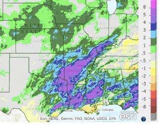
The article also points out that high contrasts in soil moisture can promote tornadoes. We know that the area from southwest Kansas to west Texas is very dry. But, when we get south southeast winds in Kansas (the usual wind direction for major tornado situations), the soil is very wet.
The map above is precipitation departure (more or less) from normal the past 30 days. Some areas are nearly eight inches above. The contrast between extremely dry west and moisture from the south is favorable. My guess (and, truly, that is all it is) is for an average to worse than average tornado season in Kansas. That means more tornadoes than the average (mean) and/or some violent tornadoes. FYI: This would be after several years with below to much below normal numbers of tornadoes.
The Wichita Eagle's article also stated,
"As National Geographic explains, the science isn't clear yet on whether climate change will make tornadoes more frequent nd intense or actually suppress them."
Actually, the science is in -- but the global warming promoters don't like it.
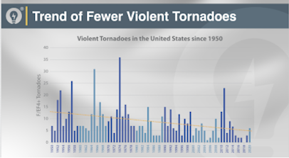
Violent tornadoes, (E)F 4 or 5 on the (enhanced) Fujita Scale, are far less frequent than they were 50 years ago. The graph below, based on official NOAA statistics, shows the numbers are way down.
Confirming that (E)F-4 and 5 tornadoes are way down are the damage figures. Since the EF and F scales are damage scales, and since high-end tornadoes do about 70% of the damage, the drop in normalized tornado damage confirms that violent tornadoes are less frequent.
Make sure you have your smartphone set to WEA alerts, a weather radio and/or StormWarn. It is vital to have at least two independent, 24 hour, tornado warning sources.


Comments
Post a Comment