Monday, August 31, 2020

Update From Southwest Louisiana

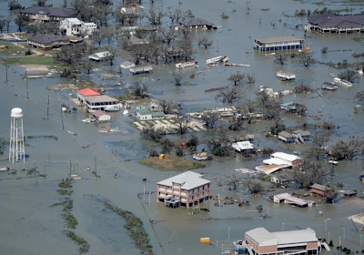
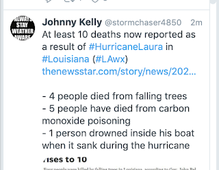
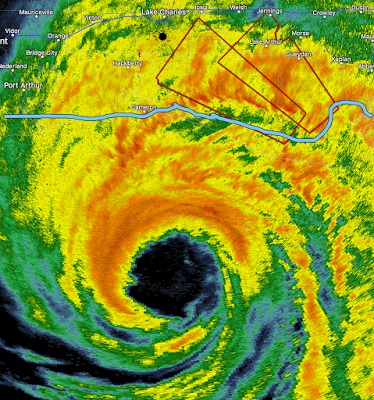
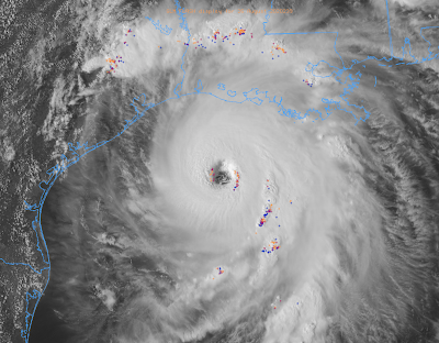
As meteorologists predicted it would be, Hurricane Laura was absolutely devastating.

Please donate to the Salvation Army's Hurricane Laura recovery fund or of another reputable charity (note: I do not include the Red Cross). 


There is a myth that office buildings are safe in hurricane and tornado-force winds. That certainly isn't true as the above photo (Capital One high-rise) and the photo below (KPLC TV studio) demonstrate.

I would also like to direct you to my comments pertaining to the numerous people on social media and in the MSM that were calling Laura a "false alarm" the day after. Those comments are here.

Addition: The much-maligned storm surge forecasts were correct.

Looking for a Short Read for the Labor Day Weekend?

Above is the newest "Goodreads" rating for When the Sirens Were Silent. It is a short book you can read in an evening. Sirens is the gripping story of the Joplin tornado and what went so terribly wrong that 161 people lost their lives.

Saturday, August 29, 2020

Why Do Newspapers Publish This Nonsense?

I'm always amused by newspapers that editorialize we must "follow science" and then turn around and publish the utterly unscientific forecasts from The Farmer's Almanac. Oy!

Friday, August 28, 2020

The Tragic Deaths From Hurricane Laura

I suspect most or all of the carbon monoxide deaths were from portable generators. Never run a generator indoors (which includes garages and basements) or near an air intake like an air conditioner.

A Pleasant Surprise: "Wired" Calls For a National Disaster Review Board

Wired magazine has an article which calls for the creation of a National Disaster Review Board, a concept I have championed since 2012. The blue link takes your to Part 1. Part 2 is here.

I won't restate all of the reasons this is a necessary expenditure of tax dollars; all of the reasons are at the blue link. I do want to state that as a political conservative, I fully realize,
  • Government often does things poorly, especially after the first generation of an agency's leadership departs. With only a few exceptions, the National Transportation Safety Board has been able to stay independent and focused. The NDRB will have to learn from them as to how to do the same.
  • "Capture" is a real danger. That is a Washington, DC term for the industry "capturing" an agency that is supposed to be its regulator. While hardly the only example, the Federal Aviation Administration has become a complete joke in its mission of regulating the airlines. We will have be on guard to prevent that from occurring. 
  • Yes, I know we have a gargantuan deficit. But, a seriously injured person or a boarded up, damaged building do not contribute tax dollars. Decreasing the skyrocketing disaster damage tolls would be a net positive for the economy.
So, please read these articles and see what you think. If you agree with me, please contact your federal representatives. I already have. 

Two Areas of Tornado Risk Today

Areas shaded in brown have a significant risk of tornadoes today. Please keep up on the weather in these regions.

Thursday, August 27, 2020

Before the Winds Subside the Complaints Begin

Weather science just a splendid job for the people of Louisiana, far east Texas and Arkansas. Hundreds of lives were saved. Yet, even while 100+mph winds were still blowing, the gripes started. I wish to comment on them and then put Hurricane Laura "to bed."

The complaints center around two themes:
  • The forecast was bad. Laura wasn't what was expected.
  • People didn't know it was coming; there was nothing done to help the poor. 
The emails below are a small sample to give you the idea. I had to report one to Twitter; it was vile. 

Let's begin with the shelters and buses. I don't know from where this came. There were many photos and stories in the media documenting people boarding buses provided by the government to shelters as far away as San Antonio. Yet, there were people upset about this from as far away as Japan.

As far as I can tell, the evacuations went off pretty much without a hitch.

With regard to the quality of the forecasts, I believe they were pretty good. You can see for yourself by scrolling down on this blog or reviewing the National Hurricane Center's Laura archive which is here. As to some of the details like storm surge, we suffer from broken instruments due to the storm. For example, one tide gage near the coast measured a surge of 9' when it failed. The official wind instruments at the Lake Charles airport failed at 139 mph. Over the next few days, NOAA and others will put people in the field to survey what actually occurred and we can do a better job of measuring what was forecast versus what actually occurred.

As important as electricity is to modern society with head indices in the South over 100° today, the forecast of power failures was excellent.

Actual outages at this time:

Regardless of the Laura forecasts' details, the bottom line is the warnings saved hundreds of lives. How do we know? We have a good comparison:
Hurricane Audrey damage, 1957
In 1957 a poorly forecast Hurricane Audrey came ashore during the night in southwest Louisiana along much the same path and almost the same time of day as Hurricane Laura. These result? At least 431 deaths (some sources day more than 500).

Audrey was forecasted to strike on the 27th of June but, instead, struck early in the morning of the 26th, catching most everyone by surprise. There was even an unsuccessful lawsuit against the Weather Bureau. Hundreds died due to drowning in the storm surge or when trees fell on the their homes.

Even though Hurricane Laura was stronger than Audrey, the death toll from Laura, currently 4, is tiny by comparison.

In 2020, in spite of all of the things that have gone wrong, the storm warning system worked well for Laura and hundreds of lives were saved. In addition to meteorologists, emergency managers and local officials deserve a great deal of credit. If you have a moment, go to Twitter or Facebook and leave compliment for the meteorologists you depend upon. They will certainly appreciate it!

It is frustrating that, time and again, meteorology continues to be the science that 'gets no respect.'

Hurricane Laura Forecast 9:30am Thursday

Laura at 9:22am It still had sustained winds of 85 mph with gusts to near 100 mph. 

Here is the forecast future path of the gradually weakening storm. 
More power failures are likely as far north as Interstate 40.

Flash flooding is a serious concern.

This will be the last forecast for Hurricane Laura.

Hurricane Laura - Followup 9:15am Thursday

Hurricane Laura was What We Feared
The recovery will take months
This is from Lake Charles this morning. Power failures and damage, unfortunately, have been extensive. Wind gusts near 150 mph have been reported. Photos from Twitter.


\
And, this is a leak from a chemical plant. The seriousness is unknown.

Power failures have been near total in many areas. Scattered power failures will creep north as the day progresses.
The radars at Ft. Polk and Lake Charles have been knocked out of service. Below is the last image before the Lake Charles radar failed at 12:53am.

This is what the Lake Charles radar looks like this morning. Even the tower is tilting. The radars are designed to survive 134 mph winds (see next photo below).

This was the radar before Laura.

This morning, the first responders represent the best of America. 

I recommend donating to the Salvation Army Disaster fund

Wednesday, August 26, 2020

Catastrophic Hurricane Laura: 10:05pm Wednesday Update

The hurricane warning will be accurate, unfortunately.

As of 10pm CDT... Hurricane Laura has winds of 150 mph with gusts to 185 according to the National Hurricane Center. We have been seeing gusts to 200+mph in "mini-swirls" rotating around the eye. Lowest barometric pressure has leveled off at about 938mb. 

If you decided to stay (I hope you did not), finish charging your phone and computer. The power will fail as the high winds move inland and won't be back for days.

Radar at 9:56pm. I have highlighted the coast in blue. The eyewall -- with the most dangerous winds -- is about two hours or so away.

Doppler radar, which measures wind speed, caught this 223 mph -- equivalent to an #F-5 tornado -- "mini-swirl" at 9:49pm.  Those were discovered by Dr. Ted Fujita in his Hurricane Andrew research.
They rotate around the eye of the storm and will continue to do so in the first two or three hours after landfall.

Interstate 20 10 is now closed, as it should be, in western Louisiana. Stay off all roads in this area the rest of the night. 

Satellite image of Hurricane Laura at 9:10pm with Houston, Lake Charles and New Orleans' locations marked.


Tornado watch in effect until 8am.

For more, follow me on Twitter @usweatherexpert 

Hurricane Laura, 6:37pm CDT Wednesday Update

Newer information higher up on the blog. 

As of 6:37pm, the sustained winds in Laura we're measured at 153 mph and the pressure has dropped to 940mb. Note: pressure down to 935mb at 7:15pm. The strengthening continues. It is just four miles an hour below Category 5 status. 


-- Original 4:30pm Posting Below --

Laura is an Absolute Monster
Satellite at 4:06pm. Colored symbols = lightning.
When lightning occurs near the eye, it is a sign of strengthening. 
Per the National Hurricane Center, the maximum sustained winds with Laura are 145 mph with higher gusts. The eye's minimum pressure of 947 millibars. They are forecasting some slight additional strengthening to 150 mph. I am forecasting it to reach Cat 5 status of 156 mph or higher (reasoning in the posting below this one).

It is past the time I can, in good conscience, recommend evacuation. There are already multiple reports of people trapped by high water. So, let's concentrate on other hazards and their mitigation. If you are in the hurricane warning zone (white area on path map below below) or just to the east, it is likely that rescue workers will be not arrive for 12 to 24 hours after the peak of the storm. 

The Storm Itself:
The weather radar from 4:05pm. It is moving NW at 15 mph.
The blue line is my estimate of the leading edge of the 50 mph winds. They will arrive in the next hour or two. The eye, which contains the strongest winds, is about 7-10 hours away from the coast - depending on location.

Power Failures
Once the power goes out, it will be days or weeks before it is restored.

The Forecast:
Brown = hurricane force winds (75 mph or more). Amber = winds 40 to 74 mph. M = major hurricane. S = winds 40-74 mph. D = depression with winds less than 40 mph. Red = hurricane warning. Blue = tropical storm warning.

Closeup of the hurricane warning "cone" or zone.
This map represents the forecast path of the eye.
Hurricane winds will extend outside of the zone, especially on the east side.
As you can see, an evacuation to the east or west makes more sense because very strong winds will occur inland which will knock out power in far east Texas, all the way to the Arkansas-Louisiana border, and in scattered parts of Arkansas. Power, once lost, will be out for days or weeks. 

Tornado Risk
This, updated, forecast is valid until 7am. Significant risk in yellow. Enhanced his in orange.

Storm Surge Will Be Life-Threatening and will extend 40 mi inland in place.

The waves are on top of the storm surge.
\
Below is the type of damage that occurs in this type of hurricane situation:

Flooding will occur in the areas with heavier rains. Five-day rainfall map below.