Catastrophic Hurricane Laura: 10:05pm Wednesday Update
The hurricane warning will be accurate, unfortunately.
As of 10pm CDT... Hurricane Laura has winds of 150 mph with gusts to 185 according to the National Hurricane Center. We have been seeing gusts to 200+mph in "mini-swirls" rotating around the eye. Lowest barometric pressure has leveled off at about 938mb.
If you decided to stay (I hope you did not), finish charging your phone and computer. The power will fail as the high winds move inland and won't be back for days.
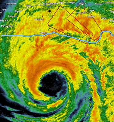
Radar at 9:56pm. I have highlighted the coast in blue. The eyewall -- with the most dangerous winds -- is about two hours or so away.
Doppler radar, which measures wind speed, caught this 223 mph -- equivalent to an #F-5 tornado -- "mini-swirl" at 9:49pm. Those were discovered by Dr. Ted Fujita in his Hurricane Andrew research.
They rotate around the eye of the storm and will continue to do so in the first two or three hours after landfall.
Interstate
Satellite image of Hurricane Laura at 9:10pm with Houston, Lake Charles and New Orleans' locations marked.
Tornado watch in effect until 8am.
For more, follow me on Twitter @usweatherexpert


Comments
Post a Comment