Posts

Showing posts with the label Texas

Tuesday's Tornado Forecast - Updated 4:30pm

Image
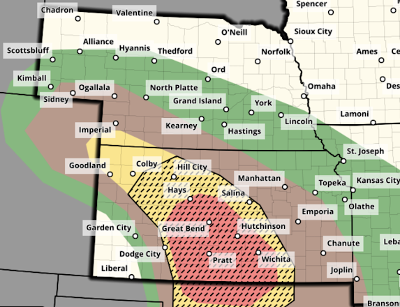
This forecast has been updated. Scroll up.  Looks like another active day tomorrow and, since we want to make sure Governor Whitmer is informed , here is a tornado outlook. There are two risk areas, please scroll down to see both.   Midwest Tornado Risk - Updated 4:25pm Monday The yellow indicates an enhanced  risk of a tornado and, if one occurs, it could be strong (hatching). The brown indicates a significant risk of tornadoes with -- again -- a chance of a strong storm. This includes far southwest Michigan. With the update, I have put a small part of northeast Kansas and western Missouri into the "significant" tornado risk area. This is because it now appears the low pressure system and warm front will stay west and north -- respectively -- of the KC area.  I am also concerned that parts of the yellow area may need to be upgraded to a higher forecast risk category for late tomorrow afternoon.  The green means a 2% chance of a tornado which is a very smal...

Issues With Wind and Solar

Image
Big Climate sent out press releases last week about how Spain -- in nice weather -- managed to run their electric grid with wind, solar and batteries for seven hours. Unfortunately, people need electricity 24/7/365. Above is what happens when a storm rolls through. If Texas used a greater percentage of wind and solar (with solar panels covered by snow and ice in places), it would have been a disaster.  And, in New York and New England...

Proposed Texas Law Regarding Emergency Management

The number of emergency management issues during the July 4 Texas flash floods were legion.  As a result, Texas Senator Charles Perry has introduced a bill reforming Texas' emergency management . The bill seems to be a real step forward. I would also add the following to the legislation: Each of the three people in line to be the emergency management leader in a major situation, as defined in the bill, must  have a tone alert weather radio with a battery backup and  an app that will transmit storm warnings for the EM's location.  Each of the three persons must attend the yearly National Weather Service spring training sessions. An equivalent commercial class(es) would be acceptable.  If a EM is ill or on vacation, they must  notify the other two.  Other states should insure they're in conformity to the principles in the proposed legislation. 

Flood Forecast Monday Afternoon to 8am Tuesday

Image
There two areas where serious flash flooding may occur from now until 8am Tuesday.  I urge those in or near the red areas to monitor the latest weather warnings. 

"We Didn't Know This Flood Was Coming"

Image
[Note, no more updates to this story as of 1pm Tuesday;  there is an updated story here .] ...so said the chief executive of Kerr County, Texas, Rob Kelly. He went on to say, "We had no reason to believe that this was going to be anything like what's happened here, none whatsoever."  I'm sorry to report that he is probably correct. The flood was underforecast and the "emergency" warnings were later than they could have been. In fairness, as of the time of this update, 1:30pm Monday, the U.S. Geological Survey has determined this was the highest crest on the Guadalupe River at Hunt, Texas, since the river gauge was installed.  As of 1p Tuesday , 105  have been confirmed to have been killed and "dozens" are missing. Those numbers imply a total death toll near 130. This past autumn, Hurricane Helene killed 249. In 2011, a single tornado killed 161 in Joplin. We must stop these mega-disasters! This is another tragic example of why America desperately n...

11:30 am Saturday, Texas Flood Update: 27People Dead, "More Than 25" Children Missing

Image
11:30am, Saturday, July 5: 27 confirmed deaths, more than 25 children missing, 270 rescued, "more deaths expected." 9:40pm. The death toll has risen to 24.   9:50pm. The number of missing campers is now 23-25, that is up from earlier.  7:45pm. Thirteen are confirmed dead. This does not count the girls from the camp which accounts for 23 missing. However,  there is (as of 7:15pm) a social media post showing two girls from Camp Mystic being carried into a hospital. This would indicate the number of missing from CM is now 21.  I don't know if these were the two carried into the hospital. 3:50pm. Texas Governor Abbott has announced at 23 children are missing from a single summer camp along the Guadalupe River southwest of Ingram, Texas. There are unconfirmed reports of people missing from other camps. A map of camps and more information is below.  4:05pm. Below is a video of a girl being rescued from a tree by helicopter this morning. State of Texas video....

This Week's Flood Risk

Image
Heavy to torrential rains are forecast to call this week in the center of the United States.  Above is the forecast rainfall from now until Saturday.  Parts of Oklahoma received more than five inches of rain this past week. With these additional rains, significant flooding is likely, especially to the south of I-40. Southeast Kansas, north Texas, and Missouri will have to be watched for flood potential but it has not be as wet recently.  Of course, I will update the forecast as the week progresses. 

Tornado Forecast for Monday

Image
This forecast has been updated as of 8:45am Monday. Please scroll up for the latest tornado forecast.  Another day of dangerous tornadoes is forecast on Monday. It will be important to monitor the weather in the areas outlined below.  Here is the color code for this forecast based on my 4-point scale. Note: the highest on my scale is an extreme risk which is  not  being forecast Monday.  Red, hatched =  high  risk of strong tornadoes.  Yellow, hatched =  enhanced  risk of strong tornadoes.. Brown = a significant risk of tornadoes.  Large or very large hail is likely over this same region. Safety Recommendations If you live in a mobile home or need a public shelter, you will find lists and maps  here . Please check it now, before the threat of a tornado or extreme winds is imminent. If you have friends or family living in housing without an adequate tornado/extreme wind sheltering area, please give them a call and refer them to ...

Dangerous Tornado Day in the Central Great Plains - Updated at 1:10pm Sunday

Image
Below are the tornado forecasts valid from 2pm CDT through 3am CDT Monday. If you live in the affected areas, I recommend monitoring the weather in these area starting in the afternoon.  Noon Update: The "high" tornado risk area (red) has extended into the Wichita Metro, including Newton, Augusta, Winfield, Ark City and Wellington. If I lived west of I-135/I35, I would begin monitoring the weather by 2:30pm.  Here is the color code for this forecast based on my 4-point scale. Note: the highest on my scale is an extreme risk which is not  being forecast today.  Red, hatched = high  risk of strong tornadoes.  Yellow, hatched = enhanced  risk of strong tornadoes.. Brown = a significant risk of tornadoes.  Large or very large hail is likely over this same region. I note that there will likely be dozens of storm chasers out today.  1:10pm Update: There are solid indications that the more alarming thunderstorms will develop from just south of Dodge...

Saturday's Tornado Forecast - Updated 4pm Saturday

Image
Tornado watch valid until 10pm. Note: this does not include the DFW Metroplex. It is covered by a lesser severe thunderstorm watch but it includes the forecast, "a tornado or two possible." -- original forecast, still valid -- The brown area -- which includes the DFW Metroplex as well as Oklahoma City and vicinity -- has a significant risk of tornadoes this afternoon and tonight. Please keep up on the weather in these areas. 

Today's Tornado Risk - Update 5:15pm Tuesday

Image
The tornado threat has been extended into Mississippi. -- original forecast below -- Here is the tornado forecast for the rest of today and into tonight. Yellow, hatched is where there is an enhanced  risk of strong tornadoes. Brown has a significant risk of tornadoes. Please keep up on the weather in these areas.  I will provide occasional updates on Twitter/X @usweatherexpert. 

Wednesday's Nadocast Tornado Forecast Plus Regional Flood Forecast

Image
This is an individual's model/AI system that does a remarkably good job in many weather situations. It can be found @nadocast on Twitter/X.  Let me interpret the Nadocast forecast for you: as with others, hatching is the potential for EF-2 or stronger tornadoes. Brown is the significant tornado threshold. Yellow is an enhanced tornado risk and red is a relatively high risk. So, both St. Louis and the DFW Metroplex have significant tornado risks Wednesday. Little Rock should keep an eye out, too. I'll post the SPC outlook along with the updated Nadocast tomorrow morning to compare.  BTW: I am well  aware of yesterday's giant tornado forecast bust. I'm debating with myself and a couple of other weather people as to what to write about it.  Flood Forecast Widespread, serious flooding is forecast for the dark blue area tomorrow through Thursday. Purple dots indicate gaged rivers reaching "major" or "record" flood stages.  The light blue area is forecast ...

Tornado Risk in Texas -- Ramps Up! 2:55p CDT

Image
Please note the forecast is for strong  tornadoes. The geographic area covered is a little larger than earlier forecasts. Please keep up on the weather the rest of this afternoon and into the evening if you are in these areas.  2:55pm update : Here is a more specific forecast of where the strong tornadoes are forecast to occur -- the yellow, watched area. The brown area has a significant chance of tornadoes. 

Tornado Watch in Effect

Image
Please keep up on the weather and note that, in addition to tornadoes, softball-sized hail  is also forecast to fall.  --- original posting --- This time, it is the Texas Panhandle.  The brown area is where there is a significant chance of tornadoes from mid-afternoon to about 10pm. Please monitor the weather in these areas.

Another Incorrect Global Warming Story

Image
I've always enjoyed visiting "Big D." I was there two years ago about this time to give a talk on storms at its Museum of Flight. But, its newspaper can be another matter when it comes to climate-related stories.  The  Dallas Morning News  has published another global warming story; one in which the way the key topic of drying weather in the Metroplex, as presented, is provably wrong.  They claim the following about Dallas' average temperature.  They are correct. After falling from about 1924 to 1984, Dallas' temperatures began to rise after 1984 and have continued to rise since.  Those of us who lived through the winters during the 1970's and early 80's (when the mid-century cooling reached its nadir) are grateful for the milder winters we have today. Still, the increasing temperatures in Dallas and across the world are a fact and they should be mitigated in an intelligent manner (a topic I've written about on many other occasions). However,  the...

Another Major Tornado Situation Forecast for Friday

Image
For the day before, the area in red represents a much higher than usual forecast of strong tornadoes. I'm providing this notice so everyone can prepare accordantly. 

Central Great Plains and Kansas -- First Tornado Risk of 2025

Image
First Significant Tornado Risk of the Season for the Central Great Plains Because the first tornado forecast of 2025 for the central Great Plains includes an enhanced  risk of strong tornadoes, I want to bring it to your attention.  Recall: the yellow, hatched area has an enhanced  risk of tornadoes. The brown area has a significant risk.  Focusing in on the higher risk area: It includes Wichita as well as area from about Medicine Lodge to Ottawa.  The severe thunderstorms in Kansas and western Oklahoma probably will not begin before about 4pm. Mid-afternoon would probably be a good time to begin monitoring the weather. Storms will continue after dark.  Reminder: if you haven't prepared your sheltering area for 2025, today would a good time to do it.  In Kansas and Oklahoma, by law, most mobile home parks of any size have shelters. However, if you don't have ready access to a shelter, today would be a good time to review this list and map of public she...