Posts

Showing posts from August, 2011

Wrap-Up on Irene

Image
I believe it is now clear to everyone that Irene was not "overhyped" by weather forecasters, 
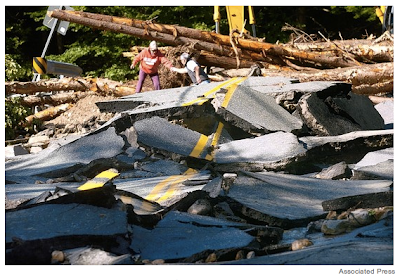
Associated Press photo of what used to be Route 4 in Vermont 
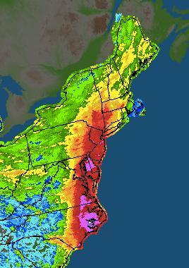
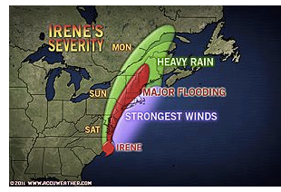
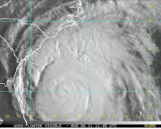
with approximately 6,000,000 still without power 4-5 days (depending on location) after the storm and communities still cut-off from the outside world, I want to close out Meteorological Musing's coverage of Irene with a remarkable time-lapse of Irene with  the National Weather Service's path forecast superimposed. Hat tip: Andrea Bleistein While they were not perfect, I'm very proud of my colleagues at AccuWeather and the National Weather Service for superb forecasts of this dangerous storm that unquestionably saved lives and dollars. The meteorological profession came through again. I'd now like to talk just a moment about preparedness. The Wall Street Journal  has an online story just posted about "slow pace" of the recovery. Political leaders encountered frustrated residents in th

WeatherData Celebrates 30 Years

Image
We had a wonderful celebration at WeatherData to conclude its 30-year run. As I mentioned on the blog last week, our name is is now AccuWeather Enterprise Solutions. There is no doubt in my mind that even bigger and better things are ahead of us. But, it was fun today to pause and think back over the last 30 years and all we have accomplished. Our colleagues at AccuWeather's home office in State College joined us via videoconference and everyone had a wonderful time.

Some Advice After 30 Years of Running a Business

Thirty years ago today was the first day in business for a tiny company, WeatherData, Inc., that I founded August 31, 1981. The chances of a startup company making it to the 30-year mark are far less than 1%. So, I thought our readers might like to know some of the principles of our success.   Never start a company until you have a well-defined goal about which you are both passionate and competent to execute. ·       100% of the entrepreneurs I have known say creating and running a business is harder than they expected. I know I expected it to be hard but I, too, found it to be extraordinarily difficult, especially since mine was 24/7. There is no way I could have stuck it out unless I was passionate about my goal of saving lives and property.  As a business owner, “the highs are very high and the lows are very low and there are many more of the latter.” ·       Every entrepreneur to whom I have given this advice has later told me it was one of the most important pieces of advice

A Great Article About the State of Hurricane Forecasting

From CNN here.

"Was Vermont Warned?"

Image
There are now two news stories (one yesterday, one today) complaining that Vermont was not warned of the danger of Irene. As I state below, my head was down in the data for days and so I cannot speak for anyone else. But, I can state that Vermont was included in the warnings Tweets that I was sending out. How explicit were the warnings? For four days, I -- and others -- were warning of the likelihood of flooding in New England. I posted this Saturday along with map outlining, in red, an area of "major flooding" that included Vermont. Calling, in advance, for evacuation preparations for a 200- year flood plain width around rivers is indicative of an extreme hazard. I know the NWS had a flash flood watch out for the area. When I wrote about all of the hazards meteorologists were trying to think through , this was one of the hazards I was talking about. So, as tragic and devastating as the record flooding has been, it is not accurate or fair to say there was "no w

Twitter Followers...

...more than doubled  tripled since this time last week. I would like to thank all of our Twitter followers, especially any we might have failed to individually thank in the craziness of the hurricane and earthquake. We enjoy hearing from you and retweets are always appreciated. If you'd like to follow, we're @usweatherexpert.

Sacrifice for Thee, But Not for Me

Image
One of my objections to the global warming movement is the hypocrisy of many of its principals. Here is a photo (hat tip: WattsUpWithThat) of global warming zealot Jim Hansen of NASA getting arrested (again) in front of the White House yesterday. He is protesting a pipeline that will bring more Canadian oil into the U.S. Photos from Flckr, posted by tarsandsandaction.org Notice anything odd in a photo of a protest about the environment? No? Let's try another showing an arrest of another person from another angle. Still don't see it?  Let's zoom in on the photo above: Look at the plastic water bottles strewn about the area! This is the White House. Don't these environmental activists have enough pride to clean up after themselves?!  How about environmentalists setting a good example? Duke and Dutchess of Windsor boarding British Airways flight Al Gore, Rajendra Pachauri (head of the IPCC), and Laurie David ("environmental activist" and prod

Here Comes Katia

Image
The name "Katrina" is retired so Tropical Storm Katia has formed in the Atlantic. She is expected to intensify into hurricane status the next few days. Important note: Don't sweat Katia. It is by no means certain she will hit any land mass and, if she does, it will not be this week.

I Didn't Wear Makeup to My Book Signings, Either

Image
New York "Daily News"

This is Worth a Separate Posting

Image
For those that believe there was too much "hype" about Irene (I do not have an opinion, my head was deep in the data and I didn't watch any coverage until landfall Sunday morning), consider these preliminary numbers from the New York Times . These statistics are from 1980 (when full-time high resolution satellite data was first becoming available) to present: Damage?  First estimates are $14 billion; ranking 8th Fatalities? Tied with Fran for 10th with 21 , but Irene's are expected to rise. UPDATE: According to the WSJ, 38 fatalities are now reported as of 10pm CDT Monday. As of 9am Tuesday, the death toll stands at 40. Irene is now #4 in terms of fatalities since 1980. Average the two and you get the 9th   6th worst hurricane in 31 years.   And, there is this when you are thinking about forecasts of hurricane intensity, Imagine, for instance, if Irene had been about 20 percent stronger when it hit New York — that it had wind speeds of about 90 miles an hou

Irene Recap: How Good Were the Forecasts?

Image
So, how did the meteorological profession do with Irene, a rare hurricane that made landfall in the Northeast United States? Meteorologists almost always do postmortems on major storms because we need to learn from our mistakes so we can do it better next time. By definition, it is difficult to forecast rare events because of the lack of analogues. For example, if there has never been a full-fledged hurricane in Manhattan in the era of skyscrapers, how will we know the level of damage a hurricane might cause? So, with that in mind, let’s go over some of the forecasts made on this blog and compare them to reality. My colleagues at AccuWeather and I made some excellent proprietary forecasts that were sometimes ahead of those available from government sources, which is what our business clients pay for. However, because I do not post those forecasts on this blog, I'm doing an analysis of the public forecasts I posted here. The early forecasts of Irene, made last Sunday (21 st ) w

Meteorologists at Work

Image
From Bill Read via Facebook comes this photo of the National Hurricane Center's staff Saturday tracking Irene. Associated Press photo by Andy Newman. I recognize the looks on their faces. It is a combination of concern and concentration and I see it on the faces of our meteorologists at AccuWeather all of the time. We are trying to outwit Mother Nature and  human nature, the latter in the sense that we have to think through hazards that might not be obvious in order to give people the information they need to protect themselves, their families and their businesses.

Recap of Rain from Irene

Image
This map is created by using a combination of rain gauges and radar estimates to fill in the gaps between gauges. Combine these excessive rainfalls with what has already been a very wet August in the region and you have a recipe for extreme flooding.

Coming Up on the Blog

Tonight, I'll recap Irene with an eye to the accuracy, or lack thereof, of the forecasts. Mid-week, I'll be talking about the 30th, and last, anniversary of WeatherData, Inc., the company I founded August 31, 1981. WeatherData has had a distinguished history, plus the chances of a start-up business reaching the 30 year mark are far less than 1%. What made us successful? Please come back for all this and more.

Should the National Weather Service Be Scaled Back?

During my 40 years as a meteorologist, I have a lot of experience with hurricanes and other major storms. I have observed that hurricanes tend to bring odd ideas to the surface. When you combine an earthquake, the odd ideas – if my email is any indication – really start flowing. Beyond the theories about airplane vapor trails and remote control of earthquakes, perhaps the oddest idea floating around now is that that the U.S. National Weather Service should be shut down or deeply scaled back. Saturday evening, a friend forwarded a Fox News op-ed calling for the NWS to be abolished. That op-ed, if you wish to read it, is here . It is easy to say, “abolish the National Weather Service.” Explaining why that is a bad idea is a bit more complicated, so I hope you will bear with me. The National Weather Service of the United States (NWS) plays a vital role that would be impossible for the private sector to fill. That is due to the unique nature of weather. Because weather d

We Now Resume Our Normal Blogging

I'll have a recap of Irene up, probably tomorrow, that I believe you'll find interesting. I'm still working on my post about the importance of the National Weather Service to the U.S. and I hope to have it up tonight.

Irene's Aftermath

Image
Here is a map of the amount of rain that has fallen with Irene, but it does not include rain that fell after 8am: White = 20" or more, purple = 15" or more up to 8am EDT this morning. A record stage is near Gilboa Dam and the town of Prattsville that "unimaginable" flooding is occurring. A reporter with Fox News is reportedly trapped along with the people in the area. More of this is going to occur the next few days. The river is expected to break the record crest by three feet! Flights are reportedly a mess. Here is my popular Airline Crisis Guide . ADDITION at 6:30pm CDT. Power failures are affecting roughly 15,000,000 people. Restoration efforts are just now getting underway in the Carolinas but more are losing power in New England with the remains of Irene.

Tropical Storm Irene Now North of NYC

Irene made landfall at NYC and has been downgraded to a tropical storm. Now that she is over land she will weaken. However, the risk of downed trees causing more power failures (3.5 million people without power and rising) and excessive rainfall causing major flooding remains. The last tornado was allowed to expire. No tornado watches are out at present.

Irene in the Big Apple

Image
Here is the Terminal Doppler Weather Radar from NYC. The dark blue winds are hurricane force (75mph) just off shore at 7am.

11:40pm Irene Update

Image
AccuWeather has a great graphic showing the future of the storm. The threats I have been talking about all week from NYC Metro east across Long Island and into coastal CT-RI and, to a lesser extent, MA are still present. If the center goes over NYC, it will be very interesting to see what the effect of the unusually large difference between Irene's surface winds and its atypical strong winds aloft on the high rise buildings. I am very concerned  about major flooding. If you live in a 200-year flood plain in the area outlined above, be thinking about what you will need to evacuate and what you will want to take with you. Here is the position (e = eye) of the storm at 11:25pm Eastern. click to enlarge this or other graphics The experimental  wind forecast system shows 70 knot (81mph) winds over New York Harbor at 4am EDT (give or take an hour) with a very small area of 80 knot winds (92 mph) just offshore. If this a perfect forecast, there will be coastal and tidal fl

"Warnings" -- Great Reading in Stormy Weather

Image
A friend forwarded this a few minutes ago, I had not seen it until now. Here are two books to read that will help you appreciate the "above and beyond" efforts meteorologists are making tonight to keep you safe if you are in the path of Irene. How dedicated are we? Well, I'm in KC for Kathleen's class reunion, yet I have been sharing ideas with our staff at AccuWeather Enterprise Solutions and I have been posting on this blog. Literally hundreds of other meteorologists are doing the same. There is an op-ed at Fox News tonight asking if the U.S. needs a National Weather Service . The answer is absolutely yes! I'll post a detailed reply to the article tomorrow evening or Monday when the hurricane situation has calmed. Stay tuned.

We Aim to Please

Image

Hurricane Winds in Eastern Virginia

Image
Here is the Doppler radar measurement of wind speeds with the deep blue color = hurricane force. The peak wind the last hour at the Richmond Airport is 60 knots = 69 mph. So, it is very likely hurricane winds are occurring in the deep blue area.  These winds and the hurricane are moving slightly east of north. The experimental wind forecast for 10pm EDT  has gusts to 70 mph making it to the NJ coast and into Chesapeake Bay with several areas of 80+ mph gusts over water. Keep in mind the scale is in knots (1 knot = 1.15 mph). click to enlarge

Based on Past Performance, The Last Person Who Should Be Giving Hurricane Advice

Image
Via Hot Air . If you have any doubt about my headline, go read the three Katrina chapters in Warnings . 

5pm Update

Image
There are only two things I'd like to update you on as of the present time, both from the National Hurricane Center: They have upped their peak rainfall amount to 20". If amounts anywhere near this large occur, major flooding is likely.  More so than with most storms…the winds with Irene increase sharply with height above the surface. As Irene moves through areas with high-rise structures…these structures will experience significantly stronger winds than indicated by the advisory intensity [which is a forecast of ground-level winds]. Winds at the 30-story level will likely be 20 percent higher than at the surface…and winds 80-100 stories up could be about 30% stronger than at the surface.  The rest of the update below is still valid.  Here is the storm at 5pm Eastern via AccuWeather radar: and, here is an experimental wind forecast valid at 2am EDT: Finally, a tornado watch continues until 8pm: Stay hunkered down if you are in the path of Irene.

New "Hurricane Hunter"

My friend Kate Bilo , former AccuWeather and now television meteorologist in Philadelphia, posted an adorable photo of her son wanting to head out to cover the storm with her at her Facebook page .

Irene's Wind Field

Image
Here is a NOAA experimental wind field forecast for Irene at 11am Eastern this morning and again at 6pm this evening. Keep in mind the wind field forecasts are in knots, so 80 knots = 92 mph. NOAA forecast, 11am Eastern. Note the relatively calm winds around the eye. Late afternoon wind forecast.  Use this as a general  guide for timing. There will be localized stronger winds and, of course, this does not forecast the location of tornadoes.

Irene On Track

Image
Here is the AccuWeather radar image of Irene at 9:20am EDT. She is officially ashore. She continues to move a little east of north on the track we have been forecasting.  Here is the forecast track from the hurricane center as of 9am EDT: Hurricane warnings  are now in effect all the way to Boston and Cape Cod. In the newly warned areas, preparation for sustained winds of 75 mph and gusts to 90-95 mph should be completed before dark tonight. Unfortunately, the power scenario is playing out as expected. According to AccuWeather , as of 6am, 189,000 homes and businesses in North Carolina, South Carolina, and Virginia are without power. AccuWeather has more great info on Irene's effects at the link. The tornado watch has been extended northward. Two tornadoes -- with damage and injuries -- have already been reported. Mobile homes were damaged. A mobile home is no place to ride out Irene. Find more substantial shelter.  Here is the current tornado watch. It will almost certainl

Tornado Watch: Eastern North Carolina

Image
Until 5am EDT. Two tornadoes have already been reported. Statistically, tornadoes are most likely in the left front quadrant (relative to its direction of movement) of a hurricane. Tornadoes may still be a threat with Irene in southern New England and Long Island when the storm moves ashore in that region. LAST BLOG POST OF THE NIGHT.

Blog Blowout

It has been a blowout day at the blog...record page views with more than double the previous record day. We went over the 250,000 unique visitors mark since Google started keeping that statistic in July, 2010. I didn't think we would hit that number until October at the earliest. Thanks so much to all that have found our blog. Please feel free to look around and comment while you are here. Mike and Mindy

Update on Irene

Image
Here is the AccuWeather radar image of Irene at 9:40pm CDT. I have marked the position of the eye and its direction of movement. Sustained winds are now 100 mph. Since the storm will be well below the Cat. 4 intensity I talked about yesterday, there should be little wind-related structural damage. To be clear, I am saying your awning or carport may suffer heavy damage but your home or business should not sustain heavy wind damage if the windows are boarded up (if the glass breaks and a pressure differential occurs, all bets are off) and away from trees (there will be many toppled trees in NC and southeast Virginia). There will be structural damage to buildings that experience the storm surge. Irene has weakened a little more which means she should be a borderline hurricane when she reaches NYC-Long Island. Before anyone rejoices too much, there is a problem: She has slowed. This means the rainfall forecast has increased along with the threat of major river flooding. What are the

Time for a Humor Break

Image
I like to break up the storm news with light notes and a little humor. Heard about this driving into work this morning and thought it was hilarious. Jim is one of my Twitter followers (thanks for the follow, Jim!) and you can be, too. Just follow @usweatherexpert.

From the Marketing Director...

We are here for you at Mike Smith Enterprises, LLC and if you need to contact Mike or me please check out www.mikesmithenterprises.com and it will be our pleasure to promptly answer your request. During a hurricane emergency like this, it's all about saving lives and caring for others in need. Be safe and  let us hear from you as you ride out the storm.

How Irene Will Affect the Outer Banks

My AccuWeather friend and colleague, Jesse Ferrell, has a detailed look, here .

The Biggest Day in the History of This Blog

From Mindy and me, thank you to everyone who has come to the blog for what is already the all-time record day in terms of page views. I also want to thank other bloggers from Andrew Sullivan/Daily Beast to Glenn Reynolds/Instapundit to my colleagues at AccuWeather who have linked to the blog. Because, if the stats are right, we have more than 3,000 entirely new readers today, let me get you caught up.  The blog is sponsored by Mike Smith Enterprises, LLC . In addition to my "day job" as Senior Vice President at AccuWeather Enterprise Solutions, I do professional speaking on disaster mitigation, global warming, and science as it applies to business. My entire career is devoted to saving lives and property when extreme weather threatens. There is a list of dates of presentations at the top of the MSE home page. MSE has a brand new Facebook page, click here . I am the author of Warnings: The True Story of How Science Tamed the Weather . There are reviews at the link. W

Some "Less Bad" News!

Image
It now looks unlikely that Irene will reattain Category 3 status and will remain an upper Category 2. The path forecast (below) is largely unchanged but you can knock about 5-10 mph off the wind speeds. That is more significant than you might think because wind force is geometric, not linear. Don't relax, however, The storm is quite large and still capable of many problems. The outer rain bands and squalls have already made it to the coasts of eastern South Carolina and North Carolina with power failures already reported. It is all downhill from here. AccuWeather radar image of Irene So, check the path information below and you have the latest.

The Power Failures Have Begun. It is Downhill From Here

2,600 homes and businesses without power in South Carolina.

On the Road With Jenna Blum and Jim Reed...

...who are chasing the storm. Jenna is blogging their chase here .

The Morning Irene Update

Image
Let's begin with her photo. She is being a bit coquettish as she keeps batting her eye at us. Right now, the eye is closed. A more intense hurricane would have an open eye.  Irene weakened a bit during the night and is now a strong category 2. However, she may strengthen back to a 3 before landfall in North Carolina. The track forecast is little changed. Hurricane warnings are out from North Carolina's coast to New York City. The hurricane watch has been extended to the New Hampshire-Maine border. Note that the National Hurricane Center is forecasting the storm to reintensify to a Category 3 ("M" = major) and, while over eastern North Carolina, sustained wind speeds are expected to reach 120 mph. The single most accurate model, the ECMWF (a/k/a "the European"), is still showing the storm moving very close to NYC, perhaps a tad west of the hurricane center. These images are exclusively available at AccuWeather's "Professional" web sit