Posts

Showing posts from May, 2016

Why We Chase Storms

Image
I have friends that have flown to Paris to see the Eiffel Tower. Others who have gone to Peru to see Machu Picchu. Our family was blessed that each of our children had foreign learning experiences when they were in college. All of that is wonderful. But, few Americans realize that storm tourists come to the Great Plains from all over the world to try to capture the elusive tornado for the same reasons. I would like to try to introduce you to why they come and why we storm chasers do what we do. This blog posting is especially timely because of two recent articles about storm chasers, including chasing during the Dodge City tornadoes of May 24. Those articles were written by people who were 1,500 miles away at the time. I was present and will include my first-hand report of what actually occurred.  Consider: London’s Big Ben is there any time you wish to see it. The Grand Canyon? Just a trip to northern Arizona. Mount Everest? While it takes tremendous skill and condition

Warnings: Another New 5-Star Review

Image
It is very gratifying to read the new reader reviews of Sirens  and Warnings   posted at Amazon. Here is an exempt of the latest review, posted just two days ago: Mike Smith recounts the meteorology revolution of the last 50 years with a balance between technical details and readability found in very few books on the subject. Many will find this a page-turner … All told, this is a story of a triumph of true science over its adversaries, whether political or just human nature. The entire review is here . And, if you would like to read the first chapter, it is here .

More Heavy Rain for Texas and Southern Oklahoma

Image
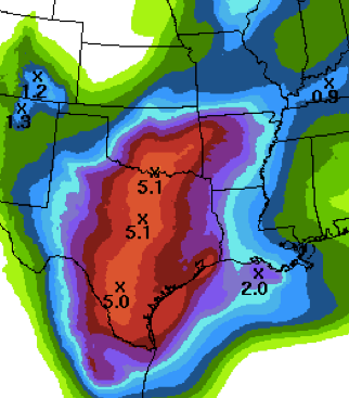
Here is the rainfall amount forecast for the rest of this week. Here is Wichita, we had an 11-year old boy swept away while playing in a flooded creek Friday and there have been several flood fatalities in Texas. Please stay away from flooded areas, especially by car.

"Honor the Fallen by Living"

For me, it is difficult to post something on Memorial Day because the sacrifices of so many is so great. I ran across this wonderful piece earlier today and I wanted to share it with you.

What a Tornado Looks Like on Radar

Image
Below, I posted about a downburst I captured using Doppler wind velocity radar yesterday. You'll see a comment asking about what a tornado looks like. Below is the Chapman tornado from Tuesday night in the velocity data. This was the Topeka radar's data. The blues/greens were winds toward the radar and the reds/oranges were winds away from the radar. Velocity data is rarely shown on television. What is more commonly shown is the reflectivity data. Here it is from the same storm at the same time. The arrow points to the "hook" echo. The whit pixel in the hook was debris lofted by the tornado. ADDITION: My friend and storm chaser Lanny Dean provided this photo of the tornado at the time these radar images were captured. Like so many, it was wrapped in rain and didn't look like a tornado. That is why it is absolutely vital to follow the warnings, not your eyes.

New Review: "When the Sirens Were Silent"

Image
A new reader review was posted earlier this month at Amazon. It was from a survivor of the Joplin tornado. In part, it says, I just read an accurate description of what I experienced that day. 5.0 out of 5 star s By  DiHof   on May 16, 2016 Format: Kindle Edition  Verified Purchase Mr. Smith's timeline and reporting of the warnings received is spot-on. The book is a short read but it makes his points clearly understandable. My son and I are alive because of my own gut instinct that came from living in Joplin since I was nine. Joplin emergency management nor the NWS played any role... This is a well written book and I encourage anyone who is concerned about the risks of tornados or who, like myself, is still trying to put together the pieces of what happened to us that day to read. The full review is here . Tragically, many people have had trouble coming to grips with what really occurred in Joplin that day, what went wrong, and how to make sure it never occurs aga

How to Recognize a Downburst on Radar

Image
Classic downburst signature on radar at 1:24pm: The greens are winds toward the radar and the reds are winds away from the radar. Before the work of Dr. Ted Fujita and Dr. John McCarthy (TDWR), this type of storm posed a mortal danger to commercial airliners. Because of their courageous work, we have not had a U.S. airliner crash in a downburst since 1994. It was once the #1 cause of airline crashes. Hundreds owe their lives to their work. Want to see how the downburst developed? Here is a quick video I made of the storm. You can see the winds hit the ground then spread out of town. That is the signature of a downburst on radar. We also had 1" hail at the Smith House from about 1:20 to 1:23pm.

Tornado Risk in Southwest Texas

Image
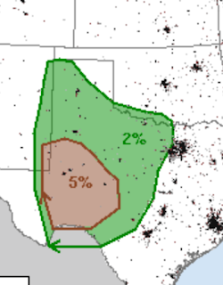
There is a chance of tornadoes in southwest Texas later today. The brown (5%) area is where there is a significant risk. Please keep an eye out on the weather in this region.

Sunday Fun: Hank Azaria Commencement Voices

Image

Bonnie is an Official Tropical Storm

Image
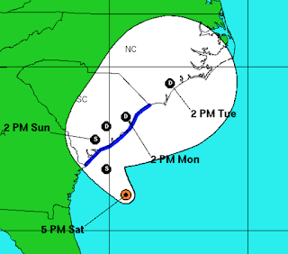
Unfortunately, Bonnie is going to make the weekend wet and gusty. AccuWeather has details.

Two Week Rainfalls

Image
Rainfall has been abundant in the central and southern Great Plains the last two weeks, breaking a dry spell in a number of areas. click to enlarge Yes, there is a small spot of more than 15 inches southeast of Wichita. In the southern area, that is a band of more than 20 inches northwest of Houston. Severe flooding has resulted in some areas.

Definition of a Landspout

We have a definitional problem related to tornadoes in Kansas. Law enforcement and at least one of our television meteorologists this afternoon proclaimed a tornado to be a "landspout." Unfortunately, they are using the terminology wrong -- and, that could get people into trouble. A landspout  is a tornado not  associated with a thunderstorm. Specifically, it is not associated with a "mesocyclone's" circulation. When a TV meteorologist is pointing at a Doppler wind display of thunderstorms saying, "Circulation, here, here and here," by definition the tornadoes associated with them are not landspouts. They are tornadoes. Why does this matter? Landspouts rarely  produce damage. Tornadoes (what the meteorologist is pointing at this afternoon) do produce damage.

A (Serious) Tip From the Boy Scouts

I just read the terrible story of a person lost 26 days in the remote Appalachians. The person, while surviving 26 days, passed away before he could be found. Back when I was a Boy Scout they taught us a simple rule. If you find yourself lost, walk until you find a stream. Then, follow the water downstream. It will, eventually, lead you to people. It is much better than walking aimlessly.

Flood Followup and Forecast

Image
Last night, I forecast two areas of heavy rains and I thought you'd be interested in learning what did, or didn't, happen (scroll down to see the forecasts). Southeast Texas Severe flooding has been reported west of Houston where more than a foot of rain (click to enlarge) has caused the closure of schools and roads. Northeast Kansas Certainly, 4+" is heavy rain but I had expected more to fall. 5-Day Rainfall Forecast More moderate to heavy rains are expected in both regions through the holiday weekend.

Today's Outlook

While there will be some storms with hail and gusty winds in the central Great Plains, no significant tornado risk exits today as far as I can tell. There is a risk of locally heavy rains in the central United States which will cause flooding. Finally, there is a significant chance of a tropical storm in the Southeast over the weekend. I'll update on that threat later today.

Note: Tropical Storm Formation is Likely

The forecast (scroll down) still looks good, unfortunately.

End of Coverage for Tonight

That has to do it for weather coverage for tonight. Thanks for reading.

Flash Flood and Tornado Risk Update, 8:40pm

Image
There are two areas of serious flash flood concern tonight, both are circled below: In some parts of both circled areas, more than four inches of rain have already fallen. Serious flash flooding may develop during the night. With regard to the tornado threat, the isolated storms you see from central Kansas to southwest of Ft. Worth have prompted a number of tornado warnings. One is still in effect near Shattuck, Oklahoma. While the chance of tornadoes is not high, one or two still may occur from these supercell thunderstorms.

6:45pm Tornado Threat Update

Image
Here is the AccuWeather regional radar from 6:32pm. There are current tornado warnings in: Eastern Colorado North of Dodge City South of Dodge City The strong low pressure system has just made it into the High Plains and I believe the storms will continue to develop during the evening. Please monitor local sources of warnings. 

3:40pm, Tornado Threat KC Area

Image
Here is the radar from 3:34pm. There is a tornado warning (red polygon) near Basher. People in the polygon need to take shelter NOW! I don't like the looks of the rapidly developing thunderstorm west of Lee's Summit. Keep an eye on this one. Finally, the cell SW of Gower (also circled) looks suspicious. Keep an eye on all three. 

Tornado Watch #4, Missouri, Kansas, and Iowa

Image
Another tornado watch has been issued, this for far east central and northeast Kansas not covered by the earlier watch (scroll down). It also includes parts of Missouri and Iowa including KC, Des Moines and St. Joseph. Tornadoes have already been reported near Topeka.

Three Tornado Watches; Warnings Already Issued

Image
As feared, things have exploded the last hour. Let's run down each tornado watch. The watch dead center in the country has a high risk of tornadoes, large hail and damaging winds as well as a "moderate" risk of violent tornadoes. The next watch, to the north, is similar although there is a "high" risk of giant hail. And, for the moment, the last tornado watch in effect, is for Colorado. The threat -- while significant -- is not quite as great. I no longer live-blog storms. Please, if you live in these areas, keep an eye on your local weather and make sure that you take cover if a tornado warning is issued.

Dangerous Tornado Situation Shaping Up!

Image
If you live in the areas outlined below, I urge you to pay attention to the weather this afternoon and tonight. If you have an infirm friend or relative, especially if they need extra time to get to shelter, please make sure they are taken care of now , before the storms develop. Remember, the significant threshold for a tornado is 5%, so the risk extends south into the Texas Big Bend. In the areas around Kansas, the hatching indicates there is a risk for strong  tornadoes like the one we saw last night in northern Kansas. A personal favor: While I was chasing near Dodge City Monday, I had friends sending me emails about what they believe was poor coverage from The Weather Channel and elsewhere. Please don't send me anything during a major storm situation that doesn't pertain to the storm and my role in it. There is nothing I can do about The Weather Channel or others during a storm. In addition to the tornado serious tornado threat, giant hail is likely. The thresh

If You are Going to Be in the Southeast Memorial Day Weekend

Image
Please keep an eye on the weather. A weather system in the tropics is going to bring cloudbursts as well as the possibility of high winds. AccuWeather has more information.

Tornado Threat Again Today

Image
Every day since Saturday, there has been tornadoes in the Great Plains. Today is the day I've worried about the most in terms of the potential for major damage and injuries.  The 5% area is the significant threat level. There could be a strong tornado or two anywhere in the outlined region.  There is also the likelihood of giant hail in the hatched areas. I will update again around noon. 

End of Coverage for Tonight; Big Severe Weather Thursday

Image
Above is the beast of a tornado that moved across northern Kansas this evening.  This was the view from the Smith House minutes ago. I expect more severe storms during the night  but I have to cease coverage on the blog and Twitter for the rest of the night. Tomorrow looks like a major severe weather day in the Great Plains. I urge you to keep up on the weather the rest of the night with local sources. I will update the blog tomorrow morning with the latest forecasts.

Tornado 7mi NW of Abilene, Kansas

Image
Via Twitter, moments ago:

Delay in Tornado Chase Report

Because of the rapidly changing weather this evening, I'm delaying the report about yesterday's Dodge City tornado chase.

Heads Up: Southeast of Wichita

Image
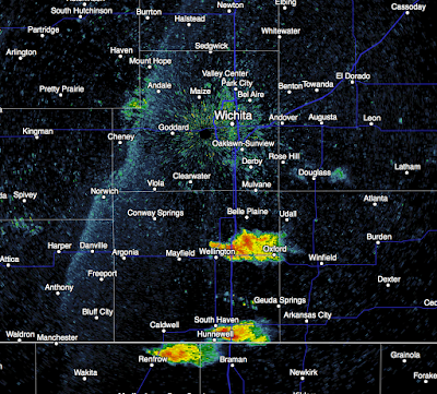
Thunderstorms developing rapidly south of Wichita that are moving ENE.The view on radar at 7:25pm. From Wichita, looking south. Keep in eye on the weather this evening!

First Tornado Warning of the Evening

Image
This is in northern Kansas, north of Salina. Radar shows rotation and a funnel cloud has been sighted. Note: We no longer live blog storms, but want to let you know it is time to begin monitoring the weather in the tornado watch area (below). I do tweet @usweatherexpert.

Tornado Watch: Kansas, N. Oklahoma

Image
Tornado watch for Kansas and northern Oklahoma until 9pm CDT. I can't urge strongly enough, if thunderstorms form they will become severe very quickly.  That means large hail, damaging winds and a chance of a tornado or two. Because this threat has developed quickly (i.e., at lunch, I was telling people we could probably breathe easy today), you may want to call your friends and relatives -- especially any people who need time to get to shelter -- and give them a "heads up."