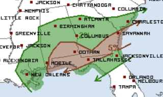
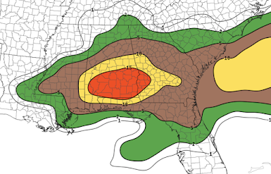
The central Great Plains and parts of the southern Plains have been exceptionally quiet when it comes to tornadoes for the last 18 months. Because it has been so long, I wanted to give this preliminary "heads up" that we might break that long streak Monday afternoon into Tuesday morning.
Of course, I will keep an eye on this for you and will update over the weekend. Stay tuned!Friday, April 30, 2021
John Kerry: The Ignorance of His CO2 Statement is Breathtaking
![]() |
Masked John Kerry on scooter. Via Drudgereport |
![]() |
Red Line is Earth's Temperature from 1900 to Now. Circled Cold From 1960-80 Was a Calamity. Now? World Prosperity. |
![]() |
From an I&I editorial this week |
Thursday, April 29, 2021
Soil Moisture For Agriculture
The Extraordinary Value of Recent Weather Forecasts
The value of weather forecasts and storm warnings isn't limited to saving lives. They have a huge economic value.
Let's begin with the extraordinary simultaneous hailstorms in San Antonio, Ft. Worth and Norman. Here is the forecast from this blog yesterday.
It correctly forecasts hail up to 4" in diameter in Texas in the orange area and singles out the DFW Metroplex. Norman is in the yellow area. Compare the forecast to the actual hail streaks which are red lines, more or less horizontal (west to east).Considering there is a nationwide shortage of auto glass plus the hassles of dealing with insurance and rental cars, if people had put their cars in garages and brought in lawn furniture, etc., considerable economic value would be gained. More on the hailstorms, here.Dangerous Overnight Flooding
Extreme Weather Summary, 12:30am
Flooding Update
Here is the rainfall for the 48 hours ending at midnight.
The pinks are rainfalls of 6 to 7 inches. They have fallen on already-saturated ground. The radar map from 12:20am (below) shows rains continuing to fall over parts of Oklahoma and northern Arkansas.- The dark red = a once in ten year rainfall event.
- There is a small area in northwest Arkansas where it is a once in 75 year rainfall event.
Severe Hailstorms
This is a map of hail swaths. The dark red areas are giant hail of 2" or more in diameter. There was softball-sized hail west of San Antonio. There were three metropolitan areas with extensive hail damage:- San Antonio
- Ft. Worth
- Norman, Oklahoma
As of this time, there are tornado watches in maroon. They will change during the night.
Wednesday, April 28, 2021
Noon Update: Tornado, Giant Hail and Flood Situation
Things have worsened since my morning update (now deleted):
Tornado Risk
The brown area has a significant risk of a tornado. In the Metroplex and south of I-20, the risk will begin after 2pm.Giant Hail Risk
In the orange area, there is the potential for hail up to four inches in diameter. This includes the DFW Metroplex.Increasing Flood Risk
Here is the rainfall up to 11:30am.
The golds are amounts of 3" or more. The pinks along I-35 south of OKC = 6 inches.Another School Bus Swept By Floodwaters
This time it was Bentonville, Arkansas, this morning.
![]() |
Brian Armis, Via Twitter |
Monday, April 26, 2021
The Story of How the Storm Warning System Came to Be
The warning system doesn't just encompass tornado warnings,
- Did you know that downbursts were once the #1 cause of commercial airliner crashes? Because of one courageous meteorologist, the last U.S. downburst crash was in 1994.
- A single unwarned U.S. hurricane killed 8,000 people (which would be 13,000 today due to population increase). We've prevented that type of disaster.
- The evacuation ahead of Hurricane Katrina was one of the largest peacetime evacuations in U.S. history -- and it saved 40,000+ lives.
Today: The 30th Anniversary of the Wichita-Andover Tornado Part II
This was a fierce tornado outbreak that extended from Iowa to Texas. Because the most severe tornadoes occurred in southern Kansas and northern Oklahoma, we will focus on those tornadoes.
The Meteorology
A powerful, negatively-tilted short wave rapidly dug into the southern Rockies.
![]() |
David Spector |
KSNW-TV's Live WSR-74C Radar at 5:45pm
I'm pointing to the developing hook echo associated with the developing Wichita-Andover Tornado north of Conway Springs (CS). I had just been handed a report of a funnel cloud north of that town. There was already a tornado on the ground over Goddard, Kansas, that was moving east northeast.Prototype NEXRAD Doppler Image, Oklahoma City, 5:47pm
The storms (above) were moving northeast. Because these storms were so distant from the radar, the prototype's resolution was poor. But, these were the first tornado thunderstorms ever shown on modern Doppler radar.First Tornado Within NEXRAD's Wind Measuring Range
Sunday, April 25, 2021
30th Anniversary of the Wichita-Andover Tornado, Part I
Tomorrow is the 30th anniversary of the Wichita-Andover Tornado, one of the most violent and historic tornadoes of the twentieth century.
Shortly after noon April 26, the National Severe Storms Forecast Center issued only its second-ever "strong language" tornado watch.
![]() |
Tornado moving through McConnell AFB |
Saturday, April 24, 2021
Flooding Concern For Ozarks Continues
- Missouri south of Interstate 70.
- The northwest half of Arkansas.
- Eastern Oklahoma.
- Far southeast Kansas.
Saturday: Tornado Forecast for the Rest of the Day
There were overnight tornadoes and at least two tornadoes this morning. Below is the tornado forecast for the rest of the day.
The brown area has a significant risk of a tornado later today or this evening. Please keep up on the weather in this area when thunderstorms approach.Please Get Your COVID Shots
I keep reading that vaccination sites are shutting down because people are not getting COVID shots.
Unless your physician has counseled you otherwise, please get them. Kathleen and I have had them and suffered no significant ill effects.
The sooner we do this, the sooner this nightmare will end.
No! No! No! No! Don't Stop Under Bridge During Tornadoes and Hailstorms
Friday, April 23, 2021
High Likelihood of Tornadoes Saturday in Southeast
- The yellow area has a enhanced risk of tornadoes.
- The red area has a high risk.