Dangerous Overnight Flooding
Extreme Weather Summary, 12:30am
Flooding Update
Here is the rainfall for the 48 hours ending at midnight.
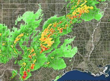
The pinks are rainfalls of 6 to 7 inches. They have fallen on already-saturated ground. The radar map from 12:20am (below) shows rains continuing to fall over parts of Oklahoma and northern Arkansas.This is a different type of flood map than we usually post. It depicts the "recurrence interval" of the rainfall over the 24 hours ending at midnight.
- The dark red = a once in ten year rainfall event.
- There is a small area in northwest Arkansas where it is a once in 75 year rainfall event.
The National Weather Service says the flooding on the Illinois River, especially near Tallequah, is extremely serious and "life-threatening." Severe flooding is also occurring in northwest Arkansas.
Severe Hailstorms
This is a map of hail swaths. The dark red areas are giant hail of 2" or more in diameter. There was softball-sized hail west of San Antonio. There were three metropolitan areas with extensive hail damage:- San Antonio
- Ft. Worth
- Norman, Oklahoma
The forecast of giant hail (posting below) up to 4" was extraordinary.
There is a nationwide autoglass shortage. It is going to be some time before all of these autos are repaired. For the insurance industry, these hail swaths represent at least $1 billion in damage and likely more.
As of this time, there are tornado watches in maroon. They will change during the night.


Comments
Post a Comment