Thursday, July 31, 2014
Rainfall Since 7am Saturday Morning
If you scroll down, you'll see a drought index map based on rainfall since 7am Saturday. These are the rainfall amounts for the last five days, since that map was published. The widespread rains in Oklahoma, New Mexico and Colorado have helped ease the drought a bit and more are forecast (see immediately below) over the next seven days.
Wednesday, July 30, 2014
Yes, More Flooding Possible in Colorado
Heard via Twitter (thanks for the feedback!) from Colorado readers that they are concerned the posting below might mislead people into thinking there is no chance of flooding in Colorado.
So, please allow me to clarify. Yes, Colorado has a flooding threat over the next 36 hours. I was trying to convey the more immediate threat has moved into Oklahoma and southwest Kansas.
The area in green is a flash flood watch. I would also add metro Tulsa to the potential flood area.
So, please allow me to clarify. Yes, Colorado has a flooding threat over the next 36 hours. I was trying to convey the more immediate threat has moved into Oklahoma and southwest Kansas.
The area in green is a flash flood watch. I would also add metro Tulsa to the potential flood area.
Shifting Heavy Rain Threat
Eads, Colorado, reported 6.21 inches of rain the last 24 hours. While light to moderate rain os forecast over many parts of Colorado the next 36 hours, the threat for the heaviest rains has shifted southeast into Oklahoma and southwest Kansas. Below is the forecast rainfall until 4pm CDT Thursday.
Some flooding is possible in low-lying and poor drainage areas. Remember, when driving, Turn Around, Don't Drown!
![]() |
Dr. Ryan Maue, click to enlarge |
Have a Young Math or Science Genius in the House?
Some ideas for cultivating his or her talent here.
Tuesday, July 29, 2014
Large Area Threatened With Flash Flooding
Green = flash flood watch. Magenta = flash flood warning.
AccuWeather Regional shows high levels of Gulf of Mexico moisture flowing northwest toward south central Wyoming and the Denver-Boulder Metro area and, to a somewhat lesser extent, southern Colorado.
There is a second area from central Oklahoma to the eastern Panhandle that has a chance of heavy rain overnight.
Monday, July 28, 2014
End of July Drought Update
The map, above, shows how much rain -- in addition to the normal amounts of rainfall -- is what is needed to end the drought in each climatological region as of 7am Saturday.
Here is the rainfall since Saturday morning:
And, here is the forecast amount of rain for the next seven days.
So, by the first of next week, the drought will ease in a few areas.
Here is the rainfall since Saturday morning:
And, here is the forecast amount of rain for the next seven days.
So, by the first of next week, the drought will ease in a few areas.
Thanks Meteorologists!
From today's USA Today:
"We've seen this happen all over the state of Tennessee over the years," Ray said, "You hardly ever see destruction this bad without somebody being killed. We're thankful, thankful to God that we didn't get hit, injured or killed."
Hmmm. Wonder why there were no deaths?
Ray said his family took shelter in their basement as the powerful weather moved through the area. When he walked out, his roof was gone.
I suspect the reason Mr. Ray and his family were in the basement because they had been trained to do so by meteorologists over the years and because of the tornado warning that was in effect on that storm.
Yes, good luck plays a role. But, so do storm warnings and storm education. In addition to the information on this blog, there were many meteorologists doing outstanding work yesterday. Even with tornadoes from Massachusetts to Tennessee, not a single death. That isn't coincidence. That is the storm warning system doing what it is designed to do.
Sunday, July 27, 2014
James Spann's Review of "Warnings"
James Spann is one of the nation's very best broadcast meteorologists and has saved innumerable lives with his outstanding coverage of severe storms. He is a man I admire and am proud to call him a friend.
He has read and reviewed Warnings: The True Story of How Science Tamed the Weather. Here are some excerpts:
For those that love weather, this is one of those books that is hard to put down. Not only is it a history of the severe weather warning system in the United States, it also weaves in the personal story of Mike’s long career...
Mike also look at the warning process for Hurricanes Andrew and Katrina in deep detail… what went right, and what went wrong. It is especially interesting to read the chapter “Murder by Bureaucracy” concerning Katrina.
I do believe you need to know where you have been to have a better understanding of where you are going. This history of severe weather warnings in this nation is a very important story for all of us, and Mike did a masterful job of telling it. I encourage all in the weather enterprise, and those interested in weather, to get a copy. It is a very good read.
You can read the review in its entirety here. You can read additional reviews or order a copy of Warnings here. If you enjoy reading this blog, you'll love Warnings.
9 Injured by Lightning at Los Angeles-Area Beaches
UPDATE 8:21PM.
ABC News is reporting one of the injured has died.
UPDATE: 8:15pm CDT
Some news reports are saying as many as 14 were struck by lightning with
nine people hospitalized.
UPDATE: Los Angeles Times 7:50pm CDT
ORIGINAL POSTING:
Photo: Venice (CA) 311. Story here. Below is the radar and lightning data (Via Twitter) from a passenger on a flight at LAX who tweeted upon hearing thunder at 2:23pm PDT. Note the lightning symbols along the beach.![]() |
David Bernard |
Storm Update: 4:22pm EDT
Several tornado-producing thunderstorms (red polygons) between Lexington, KY and the Tri-Cities in Tenn.
Strong thunderstorm moving through Columbus, OH Metro.
And, approaching the west part of Indianapolis metro.
Strong thunderstorm moving through Columbus, OH Metro.
And, approaching the west part of Indianapolis metro.
Today's Tornado and Severe Thunderstorm Threat
Storms have already developed and it is going to the a busy day.
Keeping in mind that 5% is the significant threshold, there is a large area where tornadoes are possible today. The hatching in the 10% area is where the Storm Prediction Center is forecasting violent tornadoes.
For thunderstorm-related winds of 58 mph or higher, 15% is the significant threshold. Probabilities are very high.
For 1" or larger hail, the significant threshold is 15%. The hatched area is where 2" or larger hail is forecast.
Thunderstorms have already developed in the region. AccuWeather is reporting more than 4,000 homes and businesses are without power in West Virginia. Here is the AccuWeather Regional Radar at 9:35am EDT:
While only JFK Airport has delays due to the storms at the moment, delays will rapidly increase with the thunderstorms. If you can get an earlier flight, it would be recommended.
If if you live in the area where tornadoes and damaging thunderstorm winds are forecast:
- Bring in trampolines, grills and outdoor furniture
- Put your car in the garage
- Get some extra cash at the ATM
- Pay attention to the wether today.
Sunday Thoughts: Helping the World's Poor
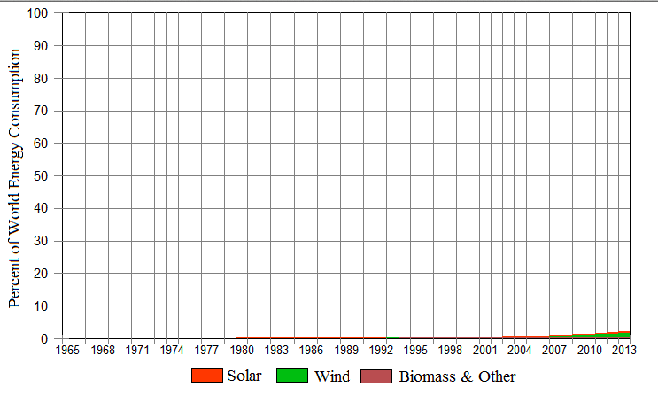
We've talked, many times, about the morality of spending hundreds of billions (yes, billions) of dollars on global warming when other investments would bring far, far more benefit to the world's poor. This piece from The Wall Street Journal is one of the best I have read on the subject. For example, we have made some progress:
Most of the original Millennium Development Goals will have been met or nearly so by 2015. Since 2000, for example, the number of people living in extreme poverty and hunger around the world will have been cut in half—an astonishing achievement.
So, how do we make progress for the rest of the developing world?
The numbers produced by this exercise are eye-catching. Every dollar spent to alleviate malnutrition can do $59 of good; on malaria, $35; on HIV, $11. As for fashionable goals such as programs intended to limit global warming to less than two degrees Celsius in the foreseeable future: just 2 cents of benefit for each dollar spent.
Please read the entire article.
Saturday, July 26, 2014
Caution: High Winds Possible
While these showers are rather small with temperatures as high as 105° there is the potential for wind gusts as high as 60 mph with some of these storm due to downbursts.
Sunday: A Potentially Dangerous Day
Fifteen percent is the significant threshold for severe thunderstorms. In the hatched area, violent tornadoes, wind gusts of 75 mph or higher and hail 2" in diameter or large may occur. The 45% area is where the best chance of violent tornadoes exists.
Airline service will be disrupted tomorrow with numerous delays and some cancellations. I also advise people attending the numerous sporting events tomorrow to keep up on the latest weather information.
This Afternoon and Tonight's Tornado and Severe Thunderstorm Outlook
The weather is going to turn much more active the next two days. For later today and tonight, the 5% tornado area is where there is a significant threat.
The probabilities of wind gusts of 58 mph or more (15% is the significant probability threshold):
And, the probability of 1" or larger hail. The hatched area is where 2" or larger hail may fall.
If you live in the areas with the higher probabilities, I suggest the following:
The probabilities of wind gusts of 58 mph or more (15% is the significant probability threshold):
And, the probability of 1" or larger hail. The hatched area is where 2" or larger hail may fall.
If you live in the areas with the higher probabilities, I suggest the following:
- Put away grills, trampolines or lawn furniture that can blow about
- Put your car in the garage or under the carport
- Keep up on the latest weather information
There is also a major risk of severe thunderstorms over the Ohio Valley east to southern New England the Middle Atlantic states tomorrow and tomorrow night. We'll have more on that later.
Friday, July 25, 2014
Film (Oh, I Hope Not!) at 11
From the "lonely lives of scientists" department comes this astronomical and biological news:
Let us hope that contact is reestablished and the geckos are rescued.
Russian scientists are attempting to re-establish control of a satellite in which a team of geckos may be copulating as part of a study into the effects of weightlessness on lizard mating.
On Thursday, the team behind the research confirmed that the vessel was not responding to commands, potentially leaving the reptiles to their out-of-this-world sexual intercourse while video footage continues to beam down to Earth.
Research satellite Foton-M4 was launched into space on July 19. The geckos are among several species on board — including insects and flora — that are part of a series of biology experiments by Russia’s Institute of Medico-Biological Problems on the effects of weightlessness on mating.
You can read the entire article here.Let us hope that contact is reestablished and the geckos are rescued.
Baby Dies in Hot Car in Wichita
It has happened here in Wichita. A ten-month old baby died yesterday after being left in a hot car.
When our children were little, car seats could be put in the front seats of the car. I have wondered if part of the reason for the spike in child deaths in hot cars is people forgetting the child is in the back seat ("out of sight out of mind"). It is claimed children are safer in the back seat, but I wonder if that includes deaths of children left in the back seat in hot weather.
I don't have any proof of that hypothesis and I do not mean to excuse the behavior of leaving a child in a hot car. But, I can't think of any other reason for all of these tragedies.
Thursday, July 24, 2014
"I'll Believe Global Warming is a Crisis When the People Telling Me It's Crisis Start Acting Like It's a Crisis"
Greenpeace is in turmoil after more than 40 staff signed a letter calling two of the group’s most senior officials to resign. The group faced ridicule last month after it emerged that Husting chose to regularly fly between his home in Luxembourg and work in Amsterdam, leaving a massive carbon footprint.
Couldn't happen to a more 'deserving' group. Commuting to work by airline. Story here. With the news yesterday that Michael Moore has nine homes, the amazing amount of hypocrisy from the climate cultists continues unabated. What was Michael Moore saying months ago after Hurricane Sandy?
"We are in big trouble. And we're still having a debate in Congress as to whether or not there really is global warming," Moore explained in disbelief. "The majority of Americans believe that we've got a climate problem. And the majority of Americans believe in science."
Joining host Piers Morgan for a live, face to face interview, the man behind such films as "Bowling for Columbine" and "Fahrenheit 9/11" suggested that Sandy should be the storm to render any further debate obsolete:
"We've allowed the ignoramuses to run the show on this. And this storm should really put an end to that."
Let's see: Michael Moore has nine homes, Al Gore has seven. NYT's global warming columnist Tom Friedman has a mega-house with a pool and guest house (below)So, Greenpeace, Moore and Gore lecture all of us about our carbon footprints while theirs are the size of Montana's. Don't do as I do, do as I say.
Wednesday, July 23, 2014
The Health Risks of the Surge of Children on the U.S. Southern Border
AscelBio is the first and only company to dynamically predict disease outbreaks in much the same way that meteorologists warn of storms (I am an investor in the company).
Because there has been so much interest as to the potential health effects of the surge in immigration, the company has produced this document so that the public and public health officials can prepare accordingly.
Rainfall and Drought Update
Here is the forecast for rainfall the next seven days:
And, here is the amount of rain -- over above the normal amounts -- needed to break the drought.
Tuesday, July 22, 2014
Monday, July 21, 2014
Derecho in Progress in North Dakota
AccuWeather regional radar at 7pm shows a violent derecho in progress that is frequently producing wind gusts of 80-85 mph and, in isolated locations, even higher. It is moving rapidly east along I-94.
An embedded tornado is also possible with this line.
Quite of bit of damage (via Facebook) has been reported. This is just one of many examples.
If you are ahead of this line, please bring in lawn furniture, trampolines, grills and other items that can be blown about. Put your car in the garage. If you have a generator, make sure it is filled with fuel.
R.I.P. James Garner
UPDATED AND BUMPED:
His fans honoring his statue in his home town of Norman, Oklahoma. Photo by J R Henly via Facebook.
ORIGINAL POSTING:
I've been a huge fan of James Garner and have even read his autobiography. I was sorry to read of his passing. He was great actor in many memorable roles. The Rockford Files was a classic. May he rest in peace.
ORIGINAL POSTING:
![]() |
James Garner Square in Norman, Oklahoma |
Today's Tornado and Damaging Wind Risks
Could be a dangerous day in the northern Plains.
Keeping in mind that 5% is significant, here is today's and this evening's tornado risk.
Damaging wind probabilities are extremely high:
Fifteen percent is the significant threshold and today's probabilities are in excess of 45%. That means there is a 45% chance of a wind gust of 58 mph or higher within 25 mi. of any given point. The hatching means there is the potential for wind gusts of 75 mph or higher!
Large hail:
Again, 15% is significant. The hatching is where hail 2" in diameter or larger is forecast to fall.
Please put away grills, lawn furniture trampolines and other objects that might blow about. Put your car in the garage ahead of the storms.
Sunday, July 20, 2014
A New Review of "When the Sirens Were Silent"
Posted at Amazon,
I greatly sensed Mike's passion for weather and simultaneous frustration for warning systems that don't work, or weather prediction centers that don't do their jobs correctly, or people who receive warning but don't act either out of stubbornness or as a result of being desensitized by overusing warning systems. All of this resulted in a dramatic loss of lives in Joplin, I wish the book had been longer because I was absolutely hooked and reeled in by the suspenseful buildup of the storm given by very vivid descriptions. I'm now going back and reading his first book, Warnings.
"Heads Up" -- Major Severe Weather Event Tomorrow
A major high wind event, including a couple of possible tornadoes, is likely in the area indicated. Fifteen percent is the significant threshold. The hatched area is where wind gusts of 75 mph or higher are forecast tomorrow afternoon and night.
Sunday Funny: "Unfortunately For Us, in the '60s and '70s, the Federal Government Only Hired Architects With Early-Onset Glaucoma"
This is the funniest photo essay I have read in a long time. While reading it, I didn't know whether to laugh or cry.
Saturday, July 19, 2014
Percent of World Energy From 'Alternative' Energy
From WattsUpWithThat:
Billions and billions and billions of dollars over four decades and you practically have to use a magnifying glass to see the contribution of wind, solar, etc. While I still have hope for solar, there is little chance that wind will be a major contributor unless there is a giant breakthrough in cheap storage capability.
Thursday, July 17, 2014
Where Was I When Apollo 11 Landed on the Moon?
This is a really good idea. Please watch the video.
My answer: Performing as Professor Harold Hill in The Music Man at Luce Park Theatre Under the Stars in Kansas City.
Red Letter Day: Carbon Tax Repealed
Subscribe to:
Posts (Atom)