Posts

Showing posts from April, 2017

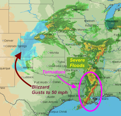
Areas of Record Flooding

Image
The dots and squares represent flood gages in areas where rivers are expected to reach or exceed flood stages. Areas without gages are where little or no flooding is forecast. Red is moderate flooding. Purple is major flooding. There are two areas where record flooding are occurring. The green arrows pointing down is where rivers have crested. In southeast Missouri, some rivers are cresting more then ten feet above the record flood stage. In south St. Louis, Interstate 44 will be closed tomorrow due to the Meramec River reaching its all-time record stage which was set in December, 2015. In eastern Oklahoma, the Illinois River will flood the town of Talequah as it will reach a record stage.

10th Anniversary of Greensburg Tornado

May 4 is the 10th anniversary of the Greensburg, Kansas, tornado. That storm destroyed the town -- literally. This week is ten year celebration of the town's comeback. If you are in the region, I highly recommend paying them a visit. I've been there several times and they are great people with great hospitality. Addition: Roy Wenzl's story of the town's recovery is must reading .

Where is the Upper Low? Southwest of Wichita

Image
At 1:45pm, the low pressure system in the upper atmosphere, which is the cause of the blizzard, the flash floods and the tornadoes is just southwest of Wichita. The showers are spiraling around the low. The low will continue to weaken and should be located near Des Moines at sunrise Monday.

Storm Total Rainfalls

Image
Let's begin with the 24-hour rainfall totals ending at 7am. More than eight inches fell in a number of areas. click to enlarge Here are the regional storm total rainfalls through 7am this morning. Please note the different color scale. Here is a storm total close-up of the area now experiencing severe flooding. Note the areas of more than ten inches. In southwest Kansas, more than four inches had fallen (with snow still falling) which represents a quarter of its average annual precipitation.

Current Weather Across Central United States

Image
This is as of 10am CDT. Interstate 70 is closed between Hays and Denver. Winds are now gusting to nearly 70 mph in the western Oklahoma Panhandle. 17" inches of snow on the ground in Colby, Kansas, along I-70. From Cindy Preszler in St. Louis: Highway 141 and I-44 is in the south St. Louis County suburb of Valley Park. I-44 will likely be closed Monday as the Meramec River reaches the second highest level in recorded history. 

Today's Tornado Risk

Image
We've already had several tornadoes today. Here is the overall tornado risk. Keep in mind that 5%, brown, is the significant threshold. And, below is a tornado watch in effect until 3pm. Please keep up on the weather in these areas.

Sunday Fun: Bill Nye Loses It

Image
You must  read Anthony Watts' and Josh's commentary (with a bonus cartoon!) pertaining to Bill Nye's latest idiocy .

Videos of the Canton, Texas Tornado

Image
Addition: Path Map --Original Posting Below-- There are reports of three dozen injured in the tornado. Here it is at its formation. If you listen carefully, you can hear the "waterfall" sound associated with tornadoes. And, here it is a few minutes later. You can see the tornado throwing trees and, again, the waterfall sound. -- Additional Video -- Here, the tornado has matured into what storm chasers call a "wedge" which means there is a low cloud base and it is at least as wide at the bottom as it is at the top. For a moment, the sound is more of a roar. You will also be able to see the result of the tornado hitting electrical transmission lines. The video below is from my AccuWeather colleague, Reed Timer.

7:45pm Flood Update

Image
The purple symbols are where major  or record  flooding is forecast from now through the next five days. If you live anywhere near one of the purple symbols, please check local sources for specific flooding information. These are the smoothed rainfall amounts over the last three days ending at 6pm. This will be the last flooding update.

Tornado Watch in Texas

Image
The watch is in effect until 10pm. A tornado has struck in or near the town of Canton, Texas, with considerable damage. No word on injuries as yet.

4:20pm Flood and Blizzard Update

Image
Here are storm total rainfall amounts as of 2pm CDT. As much as 9 inches have fallen over far southwest Missouri. Severe flooding is being reported around Branson as well as other locations. The magenta are current flash flooding warnings. The greens are various flood forecasts and warnings. The orange = blizzard warnings!  Power failures are high likely. The pink is a winter storm warning. Unfortunately, more rain is on the way. Here are the forecasts for for the next three days. In the High Plains it is a forecast of the moisture content of the snow. 

The Environmentalists Finish With Washington for Another Year

Image
Big Climate is finished trashing Washington, DC for another year. So glad they let us know that the rest of us need to treasure the environment.

2pm Flood Update. Heavy Rains Continue

Image
Radar at 1:55pm. Click to enlarge. Earlier forecast still looks good.

The Anti-Global Warming March...

Image
...in Denver today. This is known as the " Al Gore Effect ."

Catastrophic Flash Flood Danger

Image
Turn Around, Don't Drown Using AccuWeather's exclusive model and NWS models that were initialized at 10am along with radar and other tools, I cannot overemphasize the flash flood danger through midnight and, likely, beyond. The forecast rainfall amounts are 10am to 10pm. Please do not travel in these areas. If you do travel, do not try to cross flooded areas by foot or by car!

Extreme Flash Flood Danger

Image
If you live in these areas, especially the red or purple, please be ready to take flood precautions. Whatever you do, do not drive into a flooded area: Turn around, don't drown!

60th Anniversary of the Ruskin Heights Tornado

Image
From the May  435 magazine: With its profound effects on many who witnessed it, the tornado spawned a generation of people interested in the weather or pursuing careers a meteorologists such as Mike Smith, who chronicled the tornado in his 2010 book,  Warnings: The True Story of How Science Tamed the Weather. May 20 is the 60th (how time passes!!) of the Ruskin Heights Tornado. This tornado killed 44 people, 7 in Kansas and 37 in the Missouri suburbs of Kansas City. It was one of the most important tornadoes in the history weather science in the United States: It was the first time the Weather Bureau issued what would now be called a tornado warning. By today's standards, 44 is a high death toll. In 1957, it was very low considering it was night and the density of the population. Three students of Grandview High School became meteorologists as a direct result of the tornado. All three would go on to make major contributions to today's tornado warnings and the l

11:30pm Tornado and Severe Thunderstorm Update

Image
Radar at 11:31pm. My overnight forecast continues more or less unchanged. We've already had at least one had at least one confirmed tornado southwest of Ft. Smith (T on map). As indicated in the original forecast, I would not be at all surprised to have an additional tornado or two during the night. The tornado threat is primarily to the south of a Ft. Smith, McAlester to Childress line. There is a threat of hail up to 3" in diameter throughout my forecast area. If you live in these areas, please make sure you follow the weather during the night. Finally, dangerous flash flooding possible to likely in the outlined areas the rest of the night. This is the last update on the blog for the night. 

10:43pm, Tornado Update

Image
Here is the location of the likely tornado as of 10:43pm. It is headed toward Pocola, OK / Bonanza, AR. Ft. Smith is in the tornado warning and should take cover. Please see my severe weather forecast below (scroll down). There could be other tornadoes in the purple polygon as well as 3"+ hail and damaging thunderstorm winds.

Tornado Warning Just Issued: 10:30pm

Image
Above posted 7:45pm 4-29-17, pertains to tornado coverage below. ORIGINAL POSTING 10The red polygon is a tornado warning. The radar is from 10:28pm. The rotation is just west of Poteau, OK. Take cover in these areas! UPDATE: 10:30PM radar. Hook echo (arrows), which is a radar signature of a tornado, is forming just north of Poteau. 10:38pm, Tornado indicated near Cameron, Oklahoma. Strong radar indication.

10:15pm Severe Weather Update

Image
My overnight forecast is unchanged from earlier. Forecast valid from 11pm to 6am. The first of the storms with potential large hail have developed over the eastern part of the forecast area at 10:11pm. The yellow polygons are where large hail is forecast in the next few minutes. More storms should develop farther west as the night progresses. The risk of large hail is high. The risk of a tornado is slight but not zero. Please make sure you have some way to get storm warning s during the night. 

Winter Storm and Flood Forecasts

Image
A winter storm that could cause significant power outages is forecast for parts of the Rocky Mountain foothills and the High Plains. The pink is a winter storm warning. The purple is a winter storm storm advisory which is a lesser condition. The dark green is a winter storm watch. There is also a serious risk of flooding developing over the next few days. The greens are various types of NWS flood forecasts and warnings. Additional rainfall will be very heavy. More than nine inches is likely to fall over the next four days. From Tulsa to St. Louis and points southeast need to be prepared for the possibility of serious flooding developing early next week.

Overnight Risk of Severe Thunderstorms and, Maybe, a Tornado

Image
I'm making this forecast because I am concerned about severe thunderstorms (large hail and damaging winds produced by thunderstorms) developing after the 10pm news this evening goes off the air. Some of the hailstones could be very large (≥2"), so this is a night to put the car in the garage and, perhaps, put away lawn furniture/trampolines, etc., that can be easily blown about. There is also some risk of tornadoes between midnight and sunrise, especially over the southern half of the area I have outlined. So, please have your weather radio, AccuWeather App , WeatherCall , or other device that will wake you up, if necessary.

Flood Risk Grows

Image
A round of thunderstorms brought light to moderate rain to the Ozarks earlier this morning. Here is the additional rainfall forecast for the next five days: If you live in or southeast of the area of heaviest forecast rain and you live in an area known to flood, you may wish to make preliminary preparations for flooding.

If You Are Traveling to the Rockies This Weekend

Image
Yes, a late season "winter" storm. This does include the Denver area. Addition, 11:30am Friday, w/r/t commenter Brian. Here is a map of the NWS watches and warnings. Pink is a winter storm warning.  Purple is a winter weather advisory. Dark green is a winter storm watch  (which means a winter storm may occur but is not imminent). You might note that this is very similar to what AccuWeather was forecasting a day ago but larger.

Kansas Weather: Never a Dull Moment

Image
Here is a map of the current weather watches and warnings in western Kansas as of 6pm: Red is a tornado warning southwest of Garden City, Kansas. Amber is a severe thunderstorm warning in eastern Colorado. And, blue? A winter storm watch!

The Climate Thugs

The National Review  has an article on the increasing thuggery of Big Climate. During the recent 'March For Science' bullets -- bullets! -- were fired into the office of climate scientist John Christy who, like me, is skeptical that global warming is a catastrophe. Or even threatened with violence. After the March for Science this past Saturday, shots were fired at the office of John Christy, a climate scientist at the University of Alabama, Hunstville, and a well-known climate-change skeptic. Christy’s colleague, Roy Spencer, reported the shooting on social media on Monday: “When some people cannot argue facts, they resort to violence to get their way. Maybe the ‘March for Science’ should have been called the ‘March to Silence.’”  This is the kind of thuggery climate leaders promote so they can keep their agenda intact. They play the victim by insisting that the Trump administration and Republicans are trying to oppress them, but they are the perpetrators, intimidating and

I Thought Global Warming Was Going to Increase Drought?

Image
Big Climate gets another one wrong. The map below represents the lowest level of drought in the United States since the University of Nebraska drought monitor began in 2000. I am waiting for the acknowledgement from the climate hysterics crowd about another incorrect forecast but I am not holding my breath.

"I Didn't Realize It Read Like a Novel..."

Image
Yesterday, I ran into a friend who had just started reading Warnings: The True Story of How Science Tamed the Weather .  In addition to the fact she was enjoying it so far, she said, "I didn't realize it read like a novel...that it is a story." As the author, I admit that has been a frustration of mine: people automatically assume it is a heavy 'science' book when it is actually written in the form of a novel and is an uplifting story. So, if you are looking for a gift for Mom, or for a graduate, or for a great book to take on your summer vacation (in hardcover or Kindle/Nook), please consider Warnings.

Flood Threat Continues

See below. Latest forecasts indicate little has changed in the threat of flooding that will develop over the next five days.

26 Years Ago Today...

...was the devastating Wichita-Andover tornado. For those who wish to learn more about that storm, I participated on a radio show for B98FM and it is here .

Serious Flooding Risk

Image
More than a foot of rain is forecast over the next five days in western Arkansas. The gold color that extents to southwest Illinois is 7" or more. Serious flooding likely will develop.

The AccuWeather App

Image
Meteorologists recommend having at least two ways of receiving storm warnings. One excellent way is the free AccuWeather app. Yesterday, as we were driving back from Dallas (blue circular symbol) on I-35, we received an NWS special weather statement due to the strong thunderstorm nearby. It arrives with a sound to let you know a message was received. The message on top of the screen (the radar image is not part of the app, I just happened to be looking at the storm) is what the messages look like. The AccuWeather app should be part of your severe weather toolbox. 

Dangerous Tornado Day Ahead

Image
This is a dangerous tornado day in parts of the South. The significant risk is the 5% area (brown). The hatched area is where violent tornadoes are forecast. I urge people in these areas to keep an eye on the weather at the very first sign of the approach of thunderstorms.

Tornado Risk Later Today and Wednesday

Image
We have a small risk (5%, brown) along the I-44 corridor from Joplin to Oklahoma City. There is also a risk of very large hail (hatched area, 2" diameter or large). There is a risk of 1" hail all the way to Kansas City and Columbia, MO. Wednesday There is a large area where tornadoes, damaging thunderstorm-generated winds and very large hail may occur. I am on the road today. Any updates will be on my twitter account:  @usweatherexpert.