Monday, October 31, 2022

Halloween Scare Cancelled: Global Warming Will NOT Be a Catastrophic

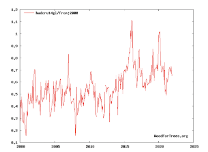
New York City Halloween Angel

When even the New York Times agrees that global warming will not be a global catastrophe, then the global warming scare is over. 


It is probably too much to hope, but -- maybe -- the MSM will stop blaming every storm of every type on global warming. 

Now, hopefully, we can address the genuine issues: The USA and the world need far more electrical generating capability. It should be primarily from hydro (where possible) and nuclear (nearly everywhere). In the meantime, we should build natural gas as a temporary bridge. We should not install another wind turbine onto the grid except in rare circumstances. 

Update: Another climate scientist agrees

Sunday, October 30, 2022

To My Liberal Friends

This is a must read pertaining to the state of the media and how it relates to the awful attack on Paul Pelosi. I try not to post about politics too often (except, occasionally, as it relates to global warming) but this is truly a must read. 

Sunday Fun: Halloween Costumes

The hottest Halloween costumes for 2022. 

Saturday, October 29, 2022

Tenth Anniversary of Hurricane Sandy

It will be ten years this evening that the eye of Hurricane Sandy made landfall in New Jersey -- at tremendous cost to our nation. 

This blog was called the "gold standard" of Sandy coverage by the president of the American Meteorological Society as we provided early warning even though the American computer models took Sandy out to sea. 

The first post (below) was seven days before landfall. As long-time readers know, I have a general policy of not forecasting hurricanes more than five days out because of the relatively high chance of warning the wrong area. 
But, I was so concerned by the potential that the developing low pressure center -- then off the coast of South America -- I felt notification was necessary; especially since the last hurricane to strike that part of the nation was in the middle of the 20th Century. The European (ECMWF) global weather forecasting model, in that era, handled hurricanes extremely well and had Sandy striking the Middle Atlantic coast. All of the other models, including the National Weather Service's models, had the storm going harmlessly out to sea.

Four days before landfall, when many were some were still thinking the storm would go out to sea, we noted the ECMWF model's variants were clustering in the Del-Mar-Va area -- which turned out to be only about 50 miles from its eventual point of landfall..

We continued our 2-5 updates per day until landfall late Monday afternoon. The post below was approximately 54 hours before landfall with a near-perfect forecast. We, and many other weather forecasters, were doing our jobs. 

Unfortunately, the National Weather Service fumbled the ball at this point and made the ridiculous decision not to issue hurricane warnings even as a hurricane headed for the densely populated East Coast. That decision caused considerable confusion amongst the public and many officials. I interrupted the meteorological coverage of this huge threat to explain why.
The decision not to issue hurricane warnings caused NYC's Mayor Michael Bloomberg ("so [Sandy] will be less dangerous"), and others, to downplay the threat of this major storm.  

Sunday's forecast -- 28 hours before landfall -- was essentially perfect. 

Tragically, Hurricane Sandy was everything we feared when it came ashore. 
When the damage was totaled up, 
  • 4th costliest hurricane in USA's history with $70 billion in damages. 
  • 72 deaths; of which 43 occurred in New York City. Lower Manhattan flooded along with parts of the other boroughs. 
  • 650,000 homes destroyed.
  • Record early-season snows occurred in some areas -- nearly unprecedented in hurricanes -- cut off thousands.
  • 8.5 million homes and businesses lost power -- affecting 25 million people -- many for weeks and even months!

Through all of this I was traveling to Kansas City for the wedding on my niece Saturday, to St. Louis on Sunday, two St. Louis speeches on Monday (the day of landfall), and back to Wichita via I-70 on Tuesday. On Tuesday, Mindy East and I viewed a steady stream of electric service trucks headed east. Today, those service trucks would likely have been on the road two days earlier. The confusion about the threat posed by the storm delayed readiness and recovery.

While Mindy drove, I took this photo of the line of 
electric utility trucks headed east on I-70 the day
after Hurricane Sandy made landfall.
It is often believed that the National Weather Service did not issue hurricane warnings and stopped referring to Sandy as a "hurricane" at the request of the White House due to the lack of hurricane coverage in the region's homeowners insurance policies -- especially since an election was imminent. I have no idea whether that contention is true. 

Given the issues surrounding the storm, I was part of an amazing team of scientists team appointed by the National Weather Service to assess the quality of the forecasts of Sandy and subsequent response. But, we were fired shortly after we began work. The NWS's very top management knew this group of scientists would be truthful with our findings and, evidently, that was the last thing the very top management of the National Weather Service and, its parent agency NOAA, wanted. 

The NWS appointed a second Sandy assessment team -- comprised of 100% government employees -- that issued a report over a narrower range of issues than the original team intended to examine. In 2022, far as I can determine, the NWS has stopped doing their lame post-storm assessments. 

While NOAA was spinning untruths and nonsense after the firing, it was extremely gratifying that many independent hurricane experts came to our defense. I urge you to read this piece because it was one of pieces of information that led me, five weeks later, to call for the creation of a National Disaster Review Board. The proposed board would be an independent federal agency modeled after the National Transportation Safety Board. Given the events of the past decade, the need for a National Disaster Review Board is greater than ever. 

Even considering the issues surrounding the warning and communications of Hurricane Sandy, there is no question the warnings saved hundreds, or even thousands, of lives. Congratulations to all of the meteorologists who worked so very hard on this storm. 

Important Addition: Below is a thread about the politics pertaining to Sandy w/r/t insurance policies. 
That Twitter thread, with comments, is here. This is likely why NOAA so greatly feared an honest assessment of Sandy. The original assessment group, clearly, would not have gone along with this scientific nonsense. Because several of us were from outside the government (NOAA could not have threatened us with firing or other sanction), we were dangerous. Thus, the entire group had to be fired.

Friday, October 28, 2022

Aeronautical Malpractice II: Flying Through a Hailstorm

On June 5, 2018, I posted a piece about an American Airlines flight that flew right through the core of a hailstorm with predictable results. 

Unfortunately, there has been a nearly identical incident; this time in Paraguay Wednesday evening. 

Below is a screen capture of lightning flashing outside of the plane. 

The Daily Mail has coverage. The nose cone of this aircraft is in even worse shape than the American flight. The radar antenna is completely gone and the windscreens are shattered. The radar is turned parallel to the camera. The antenna is still there. 

This thunderstorm encounter was even less excusable (if that's possible) than the American Airlines' (AA) encounter as it was night and lightning would have been visible before the plane entered the storm. That should have prompted the crew to closely examine the onboard radar using varying tilts. That they didn't, as with the AA example, is aeronautical malpractice. 

I will also raise a new issue: where are the flight dispatchers?! The captain and the flight dispatcher are -- by aviation law -- jointly responsible for the safe conduct of the flight. They are able to see the moment by moment position and altitude of the plane as well as the ground-based radar. In these thunderstorm cases, are they intervening by sending updated info to the flight crew?

Commercial aviation is amazingly safe. That is why these thunderstorm encounters are so mystifying: both were obvious yet they occurred anyway. I continue to be concerned that there is a subset of pilots today that do not have sufficient respect for thunderstorms and what they can do to any aircraft. 

Thank goodness the plane safely made it to the ground. 

UPDATE: 
Here is a video with more on this incident. He has the typical airline pilot attitude, "hey we might have endangered the lives of the passengers but we got everything on the ground so, 'no harm, no foul.'"

Hat tip: John Robinson. 

Thursday, October 27, 2022

Best-Ever Quote on Renewable Energy...

How can $3.8 trillion buy you nothing? Well, it hasn’t bought exactly nothing. It has bought you a bunch of useless crap while also doing exactly what it is intended to do: transfer great amounts of wealth to the friends and families of powerful people and transfer huge amounts of power into the hands of politicians and bureaucrats who are gaining control over every aspect of our lives.

 The quote is contained in this excellent, brief, essay. Don't miss reading it!

Worthwhile Climate Science Interview...

 ...that will get zero media coverage because it accurate -- which means it is not alarming. 

Details are here

Wednesday, October 26, 2022

Winter Wheat Belt Storm Total Rainfall

Here are the storm total rainfalls from the recent storm that passed out of the area yesterday. 

Tuesday, October 25, 2022

Tornado Watch: Alabama and Tennessee

There is a pretty good chance of tornadoes in this area from now until 7pm. Please monitor local sources of weather warnings. 

Or, sign up for StormWarn by clicking here. For just $25/yr it will call up to two phone numbers with tornado or ≥ 80 mph wind warnings but only if you are in the direct path of the storm. No false alarms in the middle of the night. 

Catching Up on Listening

Better Than Nuthin' with Ken Root Podcast
If you haven't had a chance, you might enjoy listening to my podcast with Ken Root about the early days of storm warnings and television meteorology. 
You can listen by clicking here

The Jim Bohannon Show, September 28
Jim Bohannon
And, if you missed my appearance on The Jim Bohannon Show, you can listen by clicking here. Please scroll down to September 28th program. 
The topic on the Jim Bohannon show was Hurricane Ian and similar extreme weather. 

If you enjoy learning about weather and meteorology, please consider my books, here and here

Happy listening!

Monday, October 24, 2022

7:40pm - UPDATE - Texas Tornado Threat

Tornado watch until midnight for the area outlined in red. Winds of 75 mph are quite possible, as well. Some of the storms may also produce 1.5" hail.

The 7:40pm radar shows severe thunderstorms (yellow polygons) that are intensifying as they move into central Texas. 

Please keep up on the weather in these areas!

Beyond midnight, this is the tornado forecast (brown) until 7am. 

24-Hour Rainfall to 3pm

Needed rains have fallen the last 24-hours in the winter wheat belt. This is the rainfall map up to 3pm.

Rain continues to fall in the southern Great Plains. Here is the radar as of 4pm.

Below is the NWS's forecast for additional rainfall for the next three days ending at 7pm Thursday.

In many areas, this rain will be sufficient for planting to occur, especially in parts of western Oklahoma where as much east two inches fell. Much more rain is needed to significantly dent the drought.

Significant Risk of Tornadoes in Texas

The brown area has a significant risk of tornadoes today. Please monitor local weather conditions. 

Sunday, October 23, 2022

Kansas at 3p: Dust Storm and Lightning

At 3pm CDT, lightning (small + symbols) and blowing dust (brown) are both occurring in Kansas -- a highly unusual situation. 
Click to enlarge 

I still believe we will see thunderstorms with damaging winds later. Please see the post below. 


Forecast for Thunderstorms With Damaging Winds

I have outlined the area where thunderstorms may develop later this afternoon and tonight that could cause wind gusts of 60 mph or stronger. If you live in these areas, please keep an eye out for local weather warnings starting late this afternoon and continuing through the night. 

UPDATE - 10:30a Monday

FYI: The blue dots are the locations of reports of thunderstorms with ≥ 58mph winds.

Sunday Fun: The Only Reason Green Energy Keeps Being Added

We can add Texas and Kansas to this cartoon. While solar and wind are beneficial for specialized uses, they are both disasters when part of the grid. For grid purposes they make electricity service less reliable and more expensive. They also do almost nothing to actually cut greenhouse gas. Because they are so unreliable, utilities must run conventional generators in the background. 

Want to decarbonize energy? Nuclear and hydro are the ways to go. 

Saturday, October 22, 2022

Desperately Needed Rain Forecasted to Fall Next Week

The winter wheat belt desperately needs rain for planing the 2023 crop. While I wish the area of rain was farther northwest, the rain depicted in this NWS forecast would be quite helpful.

The first significant snow of the 2022-23 winter is forecasted to fall in the Mountain West.
AccuWeather

There is the possibility of severe thunderstorms in parts of the central Great Plains late tomorrow afternoon and throughout the evening. Please check back tomorrow for updated info. 

Friday, October 21, 2022

A Single Story That Tells Us All We Need to Know About Wind Energy

More here. Take away the subsidies and no one would build wind turbines. 

Some Drought Relief on the Way

The latest Palmer Drought Index shows the severe drought conditions in the central and southern 
Great Plains as well as in parts of California and Oregon. Both areas will be helped by three low pressure systems that will move through the northwest and central USA during the next 15 days. 

Forecast Rainfall for the Next Seven Days
The first heavy snow of the season is forecast for the mountains in the West. 

Rainfall Out to Two Weeks
Below is a map that shows the amount rainfall above or below normal for the next two weeks.
There is also a chance of severe thunderstorms this weekend in the Great Plains. I'll have more on that tonight or tomorrow. 

Seven Times 'Disinformation' Was the Truth

In most of these, the mainstream media and government told us the opposite of what was actually true. 

The list is here

Thursday, October 20, 2022

Thought For the Day

Giving money and power to government is like 
giving whiskey and a sports car to a teenage boy. 

Given the vast corruption in our government as revealed by the multiple investigative stories by the Wall Street Journal this year (most recent here), we should be doing everything we can to eliminate many federal agencies (FBI, etc.) and scale back far more of them (EPA, Education, etc.). 

Wednesday, October 19, 2022

This is Required Reading

We desperately need younger, more creative ideas in the United States. Here are some good ones

Monday, October 17, 2022

75 Years Ago Today...

....Chuck Yeager became the first person to ever fly faster than the speed of sound. He truly had "the right stuff." Make it a point to read or watch the movie The Right Stuff. With the exception of what we now know was unfair treatment of Gus Grissom, both the book and movie are outstanding. 

October's Required Reading: "Good Intentions"

 This is an absolute must read

New Postcast Posted

I recorded a podcast with my friend Ken Root and it is here if you wish to listen. I think you will enjoy it!

Here is the link to the book we discussed

Need Weather-Related Stock Photography?

We have a wide variety of photography, especially related to weather, at Adobe Stock Photography. Please check it out. 

Sunday, October 16, 2022

The White House is Focusing on Global Warming....ART?!

War in the Ukraine with nuclear weapons' use threatened. The strategic oil reserve at the lowest level since it was first filled. China and North Korea saber rattling. Inflation through the roof. Burgeoning federal deficit.

So, what is the White House focusing on? Global warming...art!
Lubchenco is a marine scientist (who know little about how the atmosphere operates) who formerly ran NOAA and, like almost all of the NOAA administrators of this century, neglected the National Weather Service. She now works for the White House climate office. 

Lubchenco was recently involved in a major scientific scandal involving a conflict of interest. 

So, it is probably not surprising the White House wants this global warming stunt to take the 'heat 'off their climate office. Still, it is absurd for federal dollars to be spent on this stunt given the issues facing our nation and the White House at this time. 

Sunday Fun: "Weather Fins"

A man in Spain has had artificial "weather fins" installed on his body in order to "hear the weather." We live in an insane world, but if you want to learn more it is here

Saturday, October 15, 2022

More Information as to Why Additional Wind and Solar Destabilize the Grid

This piece, by an engineer, is rather technical in places but it explains well the undesirability of adding more wind and solar to the grid. 

Nuclear, on the other, is a good idea. 

Friday, October 14, 2022

Sick...Sick...Sick!!

As I said on Twitter, this way of thinking is sick. If you wish to read it, the story is here

Even worse, is this from Politico:
Putin is a 'green' hero because he has killed tens of thousands but, in the process, cut off conventional energy to Europe. 

While there are some dedicated scientists in the field of environmental science, almost all of the 'leaders' hate humanity (except themselves!) or are profiteers. 

Thursday, October 13, 2022

WHAT Global Warming?

World

We have had another "pause" in global warming. Here is the world temperature data since 2000.
Temperatures were late from about 2002 to 2013, a period known as The Pause. Temperatures shot up from then until 2016 which was a period with a strong El Nino (warm water in the equatorial Pacific). Since then -- a period with La Nina (cold water) -- temperatures have been flat to falling. 

It is fair to point out that none of the above was forecasted by the climate models. We have previously covered the crop production issues in various parts of the world. 

That said, it is quite likely temperatures will start to rise again with the next El Nino.

United States

Things are much more puzzling in the United States as we have had no warming since the state-of-the-art U.S. Historical Climate Network -- which was intended to absolutely prove global warming -- was installed. 
This is an extremely surprising result that climate science has not explained. 

As long-time readers know, I am not a fan of the climate models and will become less of a fan unless we get genuine answers for these unexpected conditions. 


Wednesday, October 12, 2022

Updated Tornado Forecast

The area in brown has a significant risk of tornadoes this evening, very possibly after dark. The green area has a tiny chance (2%) of tornadoes. Tornadoes after dark, statistically, are nearly three times more deadly than daylight storms. 

Now is a great time to subscribe to StormWarn. For about $2 per month, you receive 24/7 notifications via your phone if you are in the direct path of a tornado or damaging (>80 mph) winds. Instantly, after we ring your phones, we send you an email notification with a snapshot of the radar which shows the storm in relation to your home or other subscription location. 

Another great thing abut using StormWarn is that there are no middle of the night awakenings for 1" hail or other non-life-threatening weather conditions. It will also not ring your phones unless you are in the direct path of the storm. 

For less than the price of a single cup of coffee, you protect yourself and your loved ones from deadly storms. 

Why You Need StormWarn!

There has just been a regional tornado outbreak in southeast Wisconsin less than two hours after a forecast of "no tornadoes" was issued by the National Weather Service. 
The above forecast was issued by the NWS's Storm Prediction Center at 11:48am. The green area has a 2% risk of tornadoes. Elsewhere, the forecast was for no risk. 

However, less than an hour later, a regional outbreak of tornadoes began in southeast Wisconsin. 
Each of the red triangles represents the location of a tornado. 

Tornadoes can be tricky to forecast. My purpose is not to criticize the National Weather Service. My goal is to illustrate why you need a tool -- StormWarn -- that will inform you that you are in danger when you are in the path of a tornado or damaging thunderstorm warnings of 80 mph or more. 

StormWarn will ring your phones when you are in the direct path of a tornado even if you are asleep in the middle of the night. The great thing is it will not warn you unless you are in the direct path -- no more loss of sleep due to hail warnings from a weather radio or for a storm 30 miles away.

For about $2 per month, get amazing peace of mind. You can sign up here. Do it today!

Wheat Belt: 24-Hour Rainfall Ending 11am

While we are grateful for any rain we can get, most of last night's rain missed the area where it is needed the most. This is wheat planting season -- hard red winter wheat is planted in September and October for harvest the following May - July. Above is the 24-hour rain amounts ending at 11am CDT.

Below is a map of where winter wheat is produced. Greener = more wheat per acre.