
Dangerous Tornado Day in the Central Great Plains - Updated at 1:10pm Sunday
Below are the tornado forecasts valid from 2pm CDT through 3am CDT Monday. If you live in the affected areas, I recommend monitoring the weather in these area starting in the afternoon. 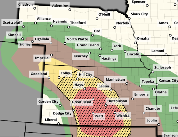
 Noon Update: The "high" tornado risk area (red) has extended into the Wichita Metro, including Newton, Augusta, Winfield, Ark City and Wellington. If I lived west of I-135/I35, I would begin monitoring the weather by 2:30pm.
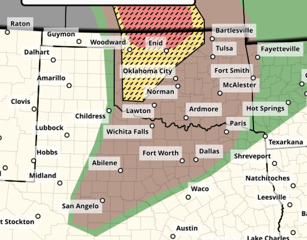
Here is the color code for this forecast based on my 4-point scale. Note: the highest on my scale is an extreme risk which is not being forecast today.


- Red, hatched = high risk of strong tornadoes.
- Yellow, hatched = enhanced risk of strong tornadoes..
- Brown = a significant risk of tornadoes.
Large or very large hail is likely over this same region.
I note that there will likely be dozens of storm chasers out today.
1:10pm Update: There are solid indications that the more alarming thunderstorms will develop from just south of Dodge City to Woodward to Vici by around 3pm.
Safety Recommendations
If you live in a mobile home or need a public shelter, you will find lists and maps here. Please check it now, before the threat of a tornado or extreme winds is imminent. If you have friends or family living in housing without an adequate tornado/extreme wind sheltering area, please give them a call and refer them to the public shelter site.
I recommend the following safety measures:
- Make sure your car is fully fueled.
- It is a good idea to have some extra cash in case of extensive power failures.
- Your smartphone and laptops should be fully charged -- but disconnect them when you hear thunder to prevent damage from a potential power surge.
- If you have a chainsaw, make sure it is fully fueled.
- Be sure you monitor the weather today and this evening and have multiple ways of receiving warnings. If you have a weather radio, install fresh batteries.
- If you are new to these areas, Lisa Teachman (NBC) in Kansas and Mike Morgan (NBC) in Oklahoma do a great job with storm coverage.
Important Note: It appears Monday will be another day with enhanced or high tornado potential in the central United States. I will have a forecast for Monday up later today.


Would like to hear your analysis of today's setup.
ReplyDeleteAs I did my hand analyses Sunday morning I was taken aback at how many missing US RAOB stations there were. A total of 16! None from Colorado, Nebraska and South Dakota, critical areas for the incoming trough. I cannot recall seeing this many missing RAOBs. IMHO this is unacceptable.
ReplyDeleteBill, I noticed the same thing when I was making my forecast. Absolutely unacceptable. Here is my problem: the weather at a number of these offices is relatively quiet. I can't believe they don't have sufficient time to spend 40 minutes to launch a balloon.
DeleteI believe the SPC did the right thing including the Wichita Metro in what I define at the "high" risk area. I expect one or two strong tornadoes today due to the stronger-than-average (for late May) upper atmospheric winds.
DeleteI have a longer explanation (because my published forecast differs from SPC's) with Monday's preliminary forecast.
Thank you for asking.