Posts

Showing posts with the label Oklahoma

High Plains Fire Aftermath - Updated

Image
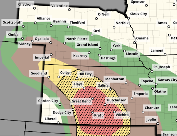
The "Ranger Road Fire" The giant orange scar (it is black in real life if viewed from an airplane) -- which indicates the ground is still warm from the fire -- is the area burned by yesterday and today's fire. Two fire fighters from Kansas were injured but not seriously. Fire fighters from Oklahoma were also injured but I have not been able to ascertain their condition at this time. Most of the firefighters in the region are volunteers.  Update: Here is a map of the area burned, so far.  The forecast for the rest of the day is at the bottom of this post.  Jadan Pappenheim took a video that is available here . A screen capture (below) doesn't even begin to capture the vastness of the fire.  The aftermath is heartbreaking. The smaller Tyrone, OK fire (not known on satellite image) did the damage shown below. The video is here .   Forecast Until 6am Thursday It is vital that everything possible be done to avoid sparks be done until tomorrow morning in these areas....

Giant Wildfire in Oklahoma and Kansas, Update 6:27pm

Image
Now providing updates on Twitter/X  @usweatherexpert.  6:27pm Update:  Fire in a neighborhood in Woodward.  KWTV, Oklahoma City.  6:20pm Update:  The fire burning into Woodward, OK where an evacuation order is in effect.  Screen capture from The Hotshot Wake Up (Twitter) video taken in Woodward.  2:50pm Update; screen capture from new video by Jaden.  Englewood, Kansas, being evacuated. The fire has crossed the border (see satellite image below). You may wish to compare that satellite image with the one farther down. Two new fires have broken out since 2pm. One in New Mexico west of Nara Visa and a second in the central Texas Panhandle.  This images was taken just before the fire east of Amarillo. 2:29pm Update There is a report of a large, multi-vehicle accident on U.S. 54 near Tyrone, OK. It is unknown if there are fatalities or injuries.  2:15pm Update From Jordan Hall, one of several semi's flipped over in high winds in the Texa...

3:300pm Tuesday: Forecast of Increased Tornado Risk

Image
I am providing updated info on Twitter/X  @usweatherexpert .  There is an enhanced risk of strong tornadoes today.  While over a small geographic area, this is a significant update from the forecast earlier today. The yellow, hatched area has an enhanced risk of strong ( ≥ EF-2) tornadoes. The brown are has a significant risk of tornadoes of a lesser intensity. Here is a zoom-in on the area with the greater risk in eastern Oklahoma and northwest Arkansas.  Please keep up on the weather throughout the afternoon in these areas. 

Nighttime Tornado Risk: Kansas and Oklahoma

Image
Here is the forecast for severe thunderstorms and tornadoes until 3am. There is also a threat of flash flooding in a few spots.  Forecasts below are until 7am.  Kansas Threat Till 7am in Brown  Oklahoma Threat till 7am in Brown NWS Storm Prediction Center is forecasting a significant chance of a tornado or two in the brown area between now and 7 am Tuesday., Please monitor the weather the rest of the night and make sure you can quickly get the family into you storm shelter area. 

Tornado and Destructive Wind Risk Late This Afternoon and Tonight

Image
It is imperative residents of the central Great Plains use the forecast to prepare for damaging winds and, perhaps, a tornado or two.  Tornado Risk The brown area has been moved south into northern Oklahoma and now includes Bartlesville, Ponca City, Enid, and Stillwater, in addition to the cities shown. In Missouri, it includes Joplin and Nevada.  Destructive Thunderstorm Winds Here is the color code: Pink and hatched: High  risk of destructive winds of 75 mph or stronger.  Red and hatched: Enhanced risk of wind gusts of 75 mph or stronger.  Yellow: Significant risk of winds 60 mph or stronger.  If you live in the red or pink areas, I urge  you to prepare for the potential for power outages, some could last a day or more. Bring in lawn furniture or trampolines which could blow about and crash into other objects -- increasing damage. Put your car in the garage or carport. 

This Week's Flood Risk

Image
Heavy to torrential rains are forecast to call this week in the center of the United States.  Above is the forecast rainfall from now until Saturday.  Parts of Oklahoma received more than five inches of rain this past week. With these additional rains, significant flooding is likely, especially to the south of I-40. Southeast Kansas, north Texas, and Missouri will have to be watched for flood potential but it has not be as wet recently.  Of course, I will update the forecast as the week progresses. 

Tornado Watch: Central High Plains

Image
-- original forecast -- The Kansas area in brown has a significant risk of tornadoes this afternoon. This includes Beaver and Buffalo, Oklahoma. This is the only area in the U.S. which has a significant risk today. Please keep up on the weather in this area later today.

Tornado Forecast for Monday

Image
This forecast has been updated as of 8:45am Monday. Please scroll up for the latest tornado forecast.  Another day of dangerous tornadoes is forecast on Monday. It will be important to monitor the weather in the areas outlined below.  Here is the color code for this forecast based on my 4-point scale. Note: the highest on my scale is an extreme risk which is  not  being forecast Monday.  Red, hatched =  high  risk of strong tornadoes.  Yellow, hatched =  enhanced  risk of strong tornadoes.. Brown = a significant risk of tornadoes.  Large or very large hail is likely over this same region. Safety Recommendations If you live in a mobile home or need a public shelter, you will find lists and maps  here . Please check it now, before the threat of a tornado or extreme winds is imminent. If you have friends or family living in housing without an adequate tornado/extreme wind sheltering area, please give them a call and refer them to ...

Dangerous Tornado Day in the Central Great Plains - Updated at 1:10pm Sunday

Image
Below are the tornado forecasts valid from 2pm CDT through 3am CDT Monday. If you live in the affected areas, I recommend monitoring the weather in these area starting in the afternoon.  Noon Update: The "high" tornado risk area (red) has extended into the Wichita Metro, including Newton, Augusta, Winfield, Ark City and Wellington. If I lived west of I-135/I35, I would begin monitoring the weather by 2:30pm.  Here is the color code for this forecast based on my 4-point scale. Note: the highest on my scale is an extreme risk which is not  being forecast today.  Red, hatched = high  risk of strong tornadoes.  Yellow, hatched = enhanced  risk of strong tornadoes.. Brown = a significant risk of tornadoes.  Large or very large hail is likely over this same region. I note that there will likely be dozens of storm chasers out today.  1:10pm Update: There are solid indications that the more alarming thunderstorms will develop from just south of Dodge...

Saturday's Tornado Forecast - Updated 4pm Saturday

Image
Tornado watch valid until 10pm. Note: this does not include the DFW Metroplex. It is covered by a lesser severe thunderstorm watch but it includes the forecast, "a tornado or two possible." -- original forecast, still valid -- The brown area -- which includes the DFW Metroplex as well as Oklahoma City and vicinity -- has a significant risk of tornadoes this afternoon and tonight. Please keep up on the weather in these areas. 

Wednesday's Nadocast Tornado Forecast Plus Regional Flood Forecast

Image
This is an individual's model/AI system that does a remarkably good job in many weather situations. It can be found @nadocast on Twitter/X.  Let me interpret the Nadocast forecast for you: as with others, hatching is the potential for EF-2 or stronger tornadoes. Brown is the significant tornado threshold. Yellow is an enhanced tornado risk and red is a relatively high risk. So, both St. Louis and the DFW Metroplex have significant tornado risks Wednesday. Little Rock should keep an eye out, too. I'll post the SPC outlook along with the updated Nadocast tomorrow morning to compare.  BTW: I am well  aware of yesterday's giant tornado forecast bust. I'm debating with myself and a couple of other weather people as to what to write about it.  Flood Forecast Widespread, serious flooding is forecast for the dark blue area tomorrow through Thursday. Purple dots indicate gaged rivers reaching "major" or "record" flood stages.  The light blue area is forecast ...

Another Major Tornado Situation Forecast for Friday

Image
For the day before, the area in red represents a much higher than usual forecast of strong tornadoes. I'm providing this notice so everyone can prepare accordantly. 

Central Great Plains and Kansas -- First Tornado Risk of 2025

Image
First Significant Tornado Risk of the Season for the Central Great Plains Because the first tornado forecast of 2025 for the central Great Plains includes an enhanced  risk of strong tornadoes, I want to bring it to your attention.  Recall: the yellow, hatched area has an enhanced  risk of tornadoes. The brown area has a significant risk.  Focusing in on the higher risk area: It includes Wichita as well as area from about Medicine Lodge to Ottawa.  The severe thunderstorms in Kansas and western Oklahoma probably will not begin before about 4pm. Mid-afternoon would probably be a good time to begin monitoring the weather. Storms will continue after dark.  Reminder: if you haven't prepared your sheltering area for 2025, today would a good time to do it.  In Kansas and Oklahoma, by law, most mobile home parks of any size have shelters. However, if you don't have ready access to a shelter, today would be a good time to review this list and map of public she...

Today's Tornado Risk - Updated 8pm

Image
7:55pm A tornado watch is now in effect until 1am. Please note that tennis ball-sized hail and 80 mph thunderstorm-generated gusts are forecast.  3:20pm Kansas:  As of 3:10pm, a line of tower cumulus clouds is growing along the dry line in Kansas. I expect thunderstorms to form along the dry line by around 5pm (give or take). These storms may produce large hail this evening near and southeast of the Kansas Turnpike.  Later tonight, a cluster of storms with damaging winds is likely from SE Kansas and Oklahoma into Missouri. You may wish to bring in trampolines and outdoor furniture that could blow about.  Oklahoma:  No tower cumulus yet but when/if thunderstorms develop, they will grow very quickly and could become quite severe.  --- original posting (still valid) --- The NWS Storm Prediction Center has added a significant chance of tornadoes in a part of Oklahoma this afternoon and evening.  As Norman and Stillwater, as well as OKC and Tulsa, are inclu...

Oklahoma Legislature Attempting to Regulate Storm Chasing

Image
Oy! This one is really bad.  Oklahoma Senate Democrat Mark Mann has introduced a bill into the Senate calling for licenses for storm chasers but only those associated with the University of Oklahoma (I sense they are, at least in part, behind this) and TV (not radio or other news media) can be licensed! Worse, the bill allows untrained storm chasers to use the same automotive warning lights used by police and fire! This is just begging for abuse with auto accidents being the consequences.  When we had the National Storm Chasing Convention in Wichita a few years ago, I invited a member of the Oklahoma Highway Patrol to sit with Kansas law enforcement and emergency management to sit with a panel of storm chasers. The OK Highway Patrol officer, Pat Mays, was adamant that they love storm chasers (as long as we drive according to the law) and begged us to call-in real-time reports.  Keeping in mind that a constitution limits governments' powers  (as opposed to the peoples...

Texas and Oklahoma: Late Week Winter Storm

Image
Texas: we don't want a repeat of the catastrophic Valentine's Weekend Winter Storm and Cold Wave that took hundreds of lives. So, I am starting my forecasts for this storm a bit earlier than usual in hopes of alerting everyone so they can take protective measures in sufficient time to mitigate the risks of cold, ice and snow.  Overview Above is the probability of 4" or more snow and/or  a quarter inch of freezing rain or sleet. This product (NWS) did well in the early states of the forecasts for the weekend blizzard and ice storm that is now moving out into the Atlantic.  ERCOT, which runs Texas' electric grid is alerting people to the impending storm and "higher electrical demand and the potential for lower reserves." How would I prepare at this point? Have the fireplace ready to go. If your chimney has not been inspected this winter, it is a good time to do so. Make sure you have plenty of firewood.  Get some extra cash, if possible. ATM's do not work f...

Updated 9:55pm: Tonight's Tornado and Damaging Wind Risk

Image
Severe Thunderstorm Watch Till 4am; Tornadoes Forecast The chances of tornadoes increase after midnight.  Have a way to be awakened if a tornado warning is issued. The brown area has a significant risk of tornadoes tonight. The red area has an enhanced  risk of 75+ mph winds. The yellow area has a significant risk of wind gusts of 60 mph or more.