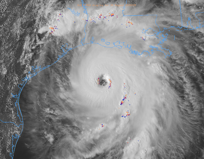
Hurricane Laura, 6:37pm CDT Wednesday Update
Newer information higher up on the blog.
As of 6:37pm, the sustained winds in Laura we're measured at 153 mph and the pressure has dropped to 940mb. Note: pressure down to 935mb at 7:15pm. The strengthening continues. It is just four miles an hour below Category 5 status.
As of 6:37pm, the sustained winds in Laura we're measured at 153 mph and the pressure has dropped to 940mb. Note: pressure down to 935mb at 7:15pm. The strengthening continues. It is just four miles an hour below Category 5 status.
-- Original 4:30pm Posting Below --
Laura is an Absolute Monster
 |
| Satellite at 4:06pm. Colored symbols = lightning. When lightning occurs near the eye, it is a sign of strengthening. |
It is past the time I can, in good conscience, recommend evacuation. There are already multiple reports of people trapped by high water. So, let's concentrate on other hazards and their mitigation. If you are in the hurricane warning zone (white area on path map below below) or just to the east, it is likely that rescue workers will be not arrive for 12 to 24 hours after the peak of the storm.
The Storm Itself:
The weather radar from 4:05pm. It is moving NW at 15 mph.
The blue line is my estimate of the leading edge of the 50 mph winds. They will arrive in the next hour or two. The eye, which contains the strongest winds, is about 7-10 hours away from the coast - depending on location.
Power Failures
Once the power goes out, it will be days or weeks before it is restored.
The Forecast:
Brown = hurricane force winds (75 mph or more). Amber = winds 40 to 74 mph. M = major hurricane. S = winds 40-74 mph. D = depression with winds less than 40 mph. Red = hurricane warning. Blue = tropical storm warning.
Closeup of the hurricane warning "cone" or zone.
 |
| This map represents the forecast path of the eye. Hurricane winds will extend outside of the zone, especially on the east side. |
Tornado Risk
This, updated, forecast is valid until 7am. Significant risk in yellow. Enhanced his in orange.
Storm Surge Will Be Life-Threatening and will extend 40 mi inland in place.
The waves are on top of the storm surge.
\
Below is the type of damage that occurs in this type of hurricane situation:
Flooding will occur in the areas with heavier rains. Five-day rainfall map below.


Comments
Post a Comment