
Tornado and Winter Storm Update, 3pm CST
Let's begin with the tornado risk.

Winter Storm Update


As to winter storm timing, here are some forecasts for 7am Thursday...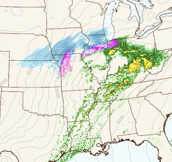
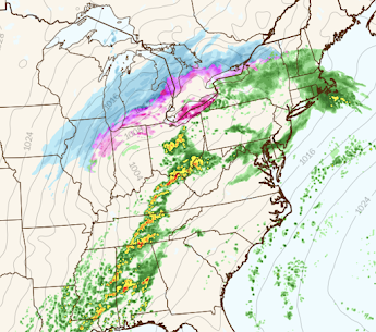
and for 6pm Thursday:
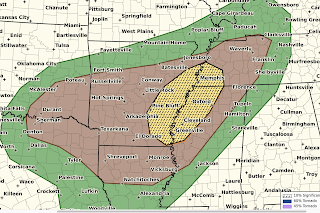
The tornado risk for tonight continues unchanged from earlier forecasts.

Color codes:
- The brown area has a significant risk of tornadoes.
- The yellow area has an enhanced risk of tornadoes and the hatching means that some of the tornadoes could be strong.
With this particular situation, there is little tornado risk before 5pm. The highest period of tornado risk will be from about 8pm until 1am Thursday. Because of the overnight nature of the threat, I highly recommend signing up for StormWarn, the nighttime telephone call only if a tornado or winds 80 mph or stronger are approaching your home. That way, you can go to sleep for the night and know that you will only be awakened if a dangerous storm is approaching. I helped set up this system but I receive no money for promoting it or anything else. I believe in active nighttime warnings for dangerous storms.
Tornado Risk Thursday and Thursday Night

Winter Storm Update
Here is the forecast snowfall maps from 6pm this evening to 6pm Friday. This does not include the snow that has already fallen in the Rockies and High Plains.


As to winter storm timing, here are some forecasts for 7am Thursday...


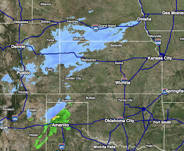
Radar at 2:56pm
Below is the radar from 2:56pm. Please keep in mind it is snowing in southeast Colorado, southwest Kansas and the Oklahoma Panhandle. It is a gap in radar coverage that prevents the snow from being shown. The snow is now spreading into Nebraska and snow emergencies have been declared in at least some south central Nebraska cities.


Comments
Post a Comment