Comprehensive Winter Storm Warning Details
Based on the computer models through 10:45pm CST, this forecast still looks good.
Under no circumstances, with the possible exception of a life-threatening medical emergency, should travel be attempted in or through the blizzard areas. Airlines will also be affected by this storm -- especially the major Delta Airlines hub in Minneapolis.
Below are the latest National Weather Service warnings.
Color code:
- Orange = blizzard warning
- Deep purple = ice storm warning (go here for details)
- Magenta = high wildfire potential
- Browns and golds = various high wind warnings (brown) and advisories.
- Pink = winter storm warning
- Deep green = winter storm watch
- Purple = winter weather advisory (lesser condition)
- Pale blue = extremely cold wind chill
Not shown: Avalanche warning in the northern Montana Rockies. There is a (amber) severe thunderstorm situation on the NY-PA border that will have expired shortly.
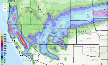
Here are my forecasts of snow amounts between 6pm this evening and 6pm Friday, using a tool from the National Weather Service.
For more information on the heavy snow in in the Sierra, go here. Elsewhere, purple colors (above) indicate amounts of more than 15 inches. When you combine it with wind gusts to 45 mph, there will be areas with drifts of more than five feet!
Please keep in mind that blizzards can = power failures, at least in a few areas. Especially if you are in a rural area, plan accordingly.
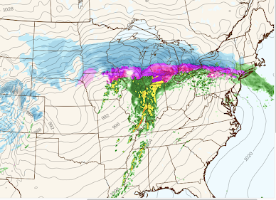
To help you time the storm, see below. Note: deeper shades of each color means heavier intensity. For example, darker blue means heavier falling storm. Magenta colors represent freezing rain (ice storm).
Forecast Radar for 8am Wednesday
 |
| Polar Wx |
Forecast Radar for 4pm Wednesday
Below is the radar as of 4:12pm.
Please note: there are many radar gaps in the mountain areas.


Comments
Post a Comment