
Derecho and Tornado Forecast: Now Until 7am Monday
I am so concerned about this situation because there will be widespread power failures in Oklahoma and, perhaps, into far south Kansas and into the Ozarks. Because of the power failures still be repaired in Michigan and California, crews will be short to make repairs from this storm. That means some people may be without power for more than 24 hours.
 It is possible that damaging wind gusts could reach as far east as St. Louis by 7am.
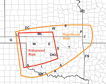 Above is my tornado threat area. As we've discussed the past few days, any tornadoes will have forward speeds of 50-60 mph. More than ever, if a tornado warning is issued for your area take cover and don't go outside to look!
 NWS Storm Prediction Center says they are going to position an initial tornado watch in this area.
 Another good source is the AccuWeather App, which tracks your position and gives you warnings based on your current location. It is free, but there are advertisements. Take your smartphone to bed with you and remember to turn off "Do Not Disturb" tonight.
It is essential that preparations be made now! See below.
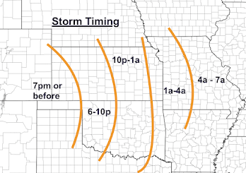
Storm Timing
Here is a rough idea of when the strongest storms will occur in a given area.

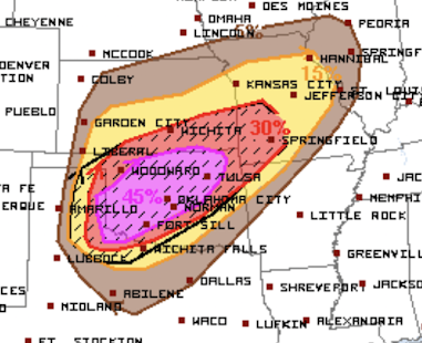
Derecho Threat

Wind gusts 100 mph or stronger are forecast to occur in the purple/hatched area. Wind gusts of 75 mph or more are forecast to occur in the red area. In both areas, power failures will occur on at least a scattered basis! You'll will find preparation suggestions below.
In the yellow area, there will be wind gusts to 60, possibly, 65 mph. Since the leaves are not yet on the trees, I would expect any power failures to be relatively small in area.
Tornado Threat


Preparation Suggestions
Make sure you have at least two independent sources of storm warnings! The forward motion of these storms will be 50-60mph, so if tornado warning or a warning of winds 80 mph or stronger is issued, there will be no time to lose -- get to shelter immediately.
Because the threat will continue after dark, I recommend StormWarn. It will call you if your home is in the path of a tornado or damaging winds (≥80 mph) for just $25/year. I make no money from your subscription; but I helped design it and believe in it. It allows you to retire for the night knowing that if the NWS issues a warning for dangerous conditions, you will receive via phone.
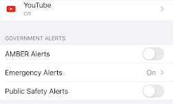
I also recommend activating the FCC's Wireless Emergency Alerts (WEA) on your smartphone. If you have an iPhone, go to "Notifications" and scroll down. Below is the way to get storm warnings and very little else (the way I want it).

Once you have your warnings communications set up:
- Charge your cell phones and laptops but take them off the chargers before the storms arrive. Power surges as the storms move through can damage those devices.
- If you have infirm friends or relatives, make provisions for them when a tornado or severe thunderstorm watch is issued. The storms will be far too fast for you to drive somewhere when a warning is issued.
- If you are in the areas with a relatively high risk of power failures, make sure your auto is fueled, that you have plenty of cash, and if you have medicines that require refrigeration, that you have a way to make sure they stay cold.
Now that the first storms have begun to form, most of my coverage will move to Twitter @usweatherexpert. I will have a brief update on the blog this evening.


Comments
Post a Comment