
How Did Yesterday's Tornado and Damaging Wind Forecast Work Out?
Let's start with the wind forecast. I agreed with the NWS SPC's forecast so that is what I posted yesterday afternoon.
 I created my own tornado forecast for the blog yesterday which is the one we will grade here.
While more reports will come in over the next day or two, I wanted to post something while this event was fresh in everyone's minds.

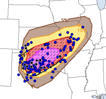
The colors represent the forecast density of reports. The blue dots represent wind reports of 60 to 74 mph.
Hatching was the indication of the forecast of wind gusts of 75 mph or more. The black squares represent actual wind gusts of 75 mph or stronger. The peak gusts, measured at official weather stations, were 114 mph at Wheeler, TX (in the hatching) and 97 mph at the Hodgeman Co., KS station (not in the hatching).
The preliminary grade I would give this is B+. It is a bit of an over-forecast of 75+mph gusts.
Tornado Forecast

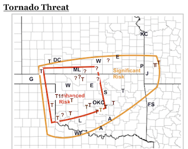
A brown T is a tornado. All of the current NWS tornado locations are on the map. There are T's that are not on the NWS's current list. Those were derived by storm chaser video or a report that appeared correct from radar. The Tf1 denotes the one tornado-caused fatality at Cheyenne, OK. Note the T for Tulsa is not a tornado.
We have a problem because some possible tornado locations will evidently not be surveyed. Those are denoted by a "?". For example, the ? near Tonkawa was based on rotation on radar and I-35 being closed due to transmission lines (the one on the tall metal poles) across the highway.
With the exception of the tornado just west southwest of Dodge City, all of the reports are within the forecast. There appears to be a greater density of reports in the Enhanced Risk (red) than in the Significant Risk (orange). If all of the ?'s are genuine tornadoes, then I would rate this forecast an A-. The "-" is because of the relatively few reports in the eastern part of the "Significant" area, meaning that part of the forecast was too geographically large. Addition: Based on Reed Timmer's video, I have added a T in Wheeler County, TX. 2nd addition, I have added two T's based on info from KWTV's tornado reports. As of 6pm, we got a report of two tornadoes in Dade County of southwest Missouri, which are now on the map. At 8:30pm, I became aware of another tornado in SW Missouri which is right on the edge of the Significant area. Fortunately, the southwest Missouri tornadoes were relatively weak.
If I get information that materially impacts the evaluation of these forecasts, then I will update and repost.
The most important thing is that this was a significant weather event for which the forecasts were quite good. It is important that these events be well forecasted and this was.


Comments
Post a Comment