Posts

Showing posts with the label downburst

40th Commemoration of the Crash of Delta 191

Image
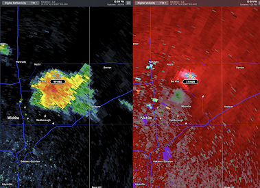
Courtesy: Ft. Worth Star-Telegram Used with permission Today is the 40th anniversary of the crash at Delta 191 at DFW International Airport. The terrible crash killed 136. Twenty-five were injured; some of the injuries were horrific. The story begins with Dr. Ted Fujita examining the crashes of Ozark Flight 809 in St. Louis (1973) and Eastern Flight 66 at JFK in New York (1975). Ted published a paper in the journal Monthly Weather Review  (February, 1977) hypothesizing the existence of a "downburst" -- a previously undiscovered feature of thunderstorms -- that could cause extreme wind shear which in turn would cause planes to crash.  In the summer of 1978, Ted ran Project NIMROD and found a downburst via radar and measured its characteristics. A couple of weeks later, I was storm chasing with my friend meteorologist Steve Amburn and I was able to take a series of seven photos that -- for the first time -- showed what a downburst looked like and its life-cycle. One of the phot...

Downburst in Johnson County, Kansas

Image
Earlier this afternoon, from Olathe, Kansas, I noticed an area where the rainfall was increasing rapidly as I looked north toward Lenexa. I enhanced the photo so the rain streaks would be more apparent. The area I focused on is between the arrows.  A few minutes later, the Kansas City Terminal Doppler Weather Radar -- which is specifically designed to detect downbursts -- depicted the downburst that formed over the Lenexa area of Johnson County. It moved east northeast into Jackson County, Missouri.  The "curly" symbol is for wind damage. Tree limbs were downed at the popular Ward Parkway Shopping Center.  The NWS WSR-88D measured wind gusts of 71 mph as it approached the shopping center. Typically, the radar overestimates wind speeds by about 10%. I imagine there was additional tree damage along the downburst's path. The electric utilities in the area have about 5,000 13,000 homes and businesses without power.  The NWS issued a timely and accurate severe thundersto...

Extraordinarily High Wildfire Risk - Updated 3:25pm

Image
1p. Multiple Wind Gusts of 80 to 85 mph Have Been Measured in West Texas During the Past Hour.  The town of Leedey, OK is being evacuated due to a wildfire at this moment..  2:15p from Bloomington, KS which is south of Augusta.  3:16pm. Satellite image of Oklahoma with OKC in the center. Bright orange = major wildfires in progress at that time.  Below is the wildfire likelihood forecast: Wind gusts to 90 mph are likely -- with a peak gust of 100 mph -- in this weather situation in the "extreme" (purple) areas. The scalloped black area is where mostly dry thunderstorms are forecast to cause downburst winds with relatively little rain. That, plus the lightning, may set fires.  It is absolutely essential that wildfires be prevented from starting.  Recommendations: Don't drag chains.  Don't throw out cigarette butts.  Avoid operating equipment that can spread sparks.  No campfires! Keep vehicles off dry grass. Stay on the road.  If you see a...

A Great Read for that Winter Getaway!

Image
If you are going to head south to get out of January's persistent cold, here is a great and uplifting book for your trip . It tells the story of how the storm warning system came to be with stories of all of the lives that have been saved -- and, the courageous scientists who make the warning system possible. It is available in paperback or Kindle . If you prefer more drama, there is the story of the worst tornado warning failure -- ever. It occurred in Joplin, Missouri, on May 22, 2011, when 161 people perished when the tornado warning was badly botched. Like Warnings,   When the Sirens Were Silent  is written like a novel and is completely non-technical. Tragically, it demonstrates that triple digit fatalities from a single tornado will resume if/when the tornado warning system fails. In the case of Sirens,  the paper version sold out very quickly. It is available in Kindle for just $2.99. This is an important story, so we priced it accordingly. 

Regarding the Southwest Airlines Flight #4069 in Oklahoma

Image
You've probably heard about the Southwest (SWA) flight from Las Vegas to Oklahoma City that dropped to ~500 feet altitude over the suburb of Yukon Tuesday night. The plane landed safely at Will Rogers World Airport at 12:21am Wednesday (19th).  It came to my attention that there are some speculating that it was downburst or a "gust front" that caused the plane to drop. There was one comment that said it looked like the 1985 crash of Delta Flight 191 in Dallas.  As the meteorological expert in one of the trials involving Delta 191 , I can say with certainty that it was not a downburst or microburst that caused the loss of altitude. In fact, weather doesn't appear to have played any part in the incident. Here's my evidence: The Sky Was Non-Threatening  Above is a screen capture from a video showing the SWA flight (arrow) near Yukon. At left are a few cumulus clouds possibly associated with the 68°F dew point at Will Rogers (WR). There was a level jet stream as th...

How Did Yesterday's Forecast Work Out?

Image
Above is the forecast posted on the blog yesterday afternoon. The brown area is for downbursts with winds of 60 mph or more. The red area is for tornadoes along with downbursts.  Aft left are the reports, so far, of what actually occurred. Blues are reports of wind damage or wind gusts of 60 mph or stronger. The red dots are tornadoes.  This forecast appears to be of A-  quality as there were high wind reports in Iowa to the northeast of the red forecast. The forecast was timely, as far as I know, the forecast was on the blog before any of the high wind or tornadoes occurred. 

4:40pm Update: Tornado Watch, Severe Thunderstorm Watch, and Downburst Threat Through This Evening

Image
NWS has issued a tornado watch for the area outlined in red.  Our thinking is somewhat similar as to the area threatened (see below). Please note the NWS says there is a "moderate" risk of EF-2 ("strong") tornadoes.  Below, the radar at 4pm with the tornado (amber) plotted with the storms. Addition at 4:23pm: 77 mph winds have been clocked at the Hutchinson airport and just southwest of the Salina in downbursts. The NWS, at 4:35pm, issued this severe thunderstorm watch -- primarily for downburst winds to 80 mph.  I'm having some technical issues with Twitter and so cannot live tweet storms this evening.  -- original, still valid, posting --- In the Great Plains, there are two areas where the weather should be watched the rest of the afternoon through about 10pm. The red area is where tornadoes, along with hail and damaging thunderstorm winds, are possible.  The brown area is where downburst winds to 65 mph are quite likely.  There is also a significant...

The Scientific Blessing of Modern Wind Shear Alerting Systems for Aviation

Image
Wow, what an afternoon in Wichita. Downbursts all over the city, including at my home. And, because two strong downbursts were near airports, we could have had a tragedy. McConnell Air Force Base The first of the downbursts occurred about 2:40pm. The peak gust from the northeast was 46 knots, which was 53 mph. "McC" points to the runway complex at the base. "D" is the center of the downburst and the arrows are the wind directions. These images are Doppler wind data from the Wichita Terminal Doppler Weather Radar, which was specifically designed to detect downbursts in time to prevent once-frequent crashes.  If you are a pilot or meteorologist, you may find the METARs of the event (KIAB) to be interesting (click to enlarge). Eisenhower National Airport Across town at Eisenhower (our commercial airline airport), they had a gust from the east southeast at 50 knots, which is 58 mph. I've circled the runway complex.  And, here are the METARs for KICT. In addition to ...

First Aviation Downburst-Caused Fatality Since 1994?

Image
To my knowledge, prior to Friday, the last downburst-caused aviation fatality was the result of the crash of US Flight 1016. That crash occurred on the northwest side of Charlotte-Douglas International Airport (KCLT for meteorologists and pilots) on July 2, 1994. It killed 37 people.  That enviable record may have ended Friday evening when a downburst-caused wind gust flipped a small  airplane awaiting takeoff at Orlando's Executive Airport at 4:58pm EDT. The airport's wind measuring equipment clocked a gust of 62 mph. The question is, "What caused the gust?" Terminal Doppler Weather Radar (TDWR) was developed in the 1990's to help bring an end to what was the #1 cause of fatal airline crashes from the 60's to the 90's. One of the TDWR's was installed to protect Orlando's International Airport (where the airliners land). However, its coverage extends northeast to include the city's Executive Airport and that data is below.  Below is a map of t...

Heads Up: Arizona

Image
I don't think I've ever seen this before. There is a significant risk of thunderstorm (downburst)-generated winds of more than 75 mph from Metro Phoenix to Kingman.  It is a good idea to prepare for these storms by putting lawn furniture and similar items indoors for the duration. Please monitor local sources of weather information at the first sign of thunderstorm formation. 

Weather As Fascinating to Read as to See

Image
As I was standing in my backyard in Wichita photographing this Oklahoma thunderstorm Sunday evening, I thought again how fascinating and challenging the weather is. Below is a photograph of the radar of the same storm.  Left is the reflectivity data, the type of radar you see on television. At right is the wind data, showing the diverging winds of a downburst. This thunderstorm was 78 miles from my home.  When I started my career, we didn't know downbursts existed, let alone did I think we would have a tool to detect them (image at right with diverging arrows). I tell the amazing story of our progress in warning of tornadoes, downbursts and hurricanes in Warnings: The True Story of How Science Tamed the Weather .  This book reads like a novel even though it is completely true.  "Goodreads" Pick up a copy. I think you'll enjoy it. 

Downburst West of Tulsa

Image
Here is a shot of the rain shaft associated with a weak downburst at 5:40pm southwest of downtown Tulsa.  You can see Tulsa's Riverside Airport in the foreground. Downbursts, even of this intensity, are dangerous to planes when they land and take-off when they are over airports.  The radar at the same time shows the storm. On the left is the reflectivity image which shows how hard it is raining. On the right is the wind. The greens are colors showing winds blowing toward the radar and reds away from the radar. The peak gusts weren't all that high, about 35 mph.  

"Curl Near the Ground? Go Around!!"

Image
While very short, storm chaser Spike recorded a terrific time-lapse of a downburst's "curl" yesterday. You can view it here .  Here is one of a sequence of photos of a downburst I took in July, 1987 -- the first of its type ever taken.  A pronounced curl = a strong downburst = strong wind shear. If you are piloting an aircraft and you see one of these curls when readying to land to take off, please:  Curl Near the Ground? Go Around!! Addition: I was reminded this morning that today is the 36th anniversary of the downburst crash of Delta 191. Here is a posting I did on the 25th anniversary of that terrible event. The good news is that thanks to Dr. Ted Fujita, Dr. John McCarthy and others aviation weather was revolutionized and the downburst was conquered in the United States.  Addition #2: A spectacular downburst video is here . Look at the curl at lower left. Violent winds and wind shear occurred. 

Downburst and Spectacular Thunderstorm

Image
The view from my home this evening.  Nothing like the Kansas Sky! This was right at sunset and the tall cumulonimbus cloud was catching the orange rays. In the foreground is a line of towering cumulus clouds along the outflow winds caused by a downburst near the Sedgwick - Sumner county line.  Below is a closeup of the towering cumulus moving toward me.  The towering cumulus were along the leading edge of a downburst's outflow.  The curved orange line represents the northern edge of downburst winds at 8:27pm. The yellow polygon is a National Weather Service severe thunderstorm warning. 

Downburst in Northeast Wichita

Image
For the second time in my life, a downburst came down directly on our home. We had pea-sized hail, torrential rain with visibility of 20 feet and wind gusts to at least 60 mph that caused the leaves to pour off our trees. It began at my home at 12:57pm. Our next door neighbor lost about half of one of their trees.  The Wichita Terminal Doppler Weather Radar (TDWR), which is designed to see downbursts, did a great job of depicting what was happening on the ground. 12:59pm Left image is the type of radar you see on TV. It shows how hard it is raining. At right is the Doppler wind velocity data.  1pm The blue dot is my home. Jabara Airport (KAAO) is one mile east southeast of us.  At 1:01pm, Jabara Airport had a wind gust of 57 mph.  Addition: Report of power poles knocked over in the area where the TDWR showed the highest winds. In the 1970's and 80's, downbursts were the #1 cause of airliner crashes . Thanks to the TDWR installations, along with airport wind shear det...

Another 5-Star Review For "Warnings"

Image
In case you received a Father's Day or graduation gift card, may I suggest Warnings: The True Story of How Science Tamed the Weather .  The newest review at Amazon: Verified Purchase A wonderful accounting of the state-of-the-art of forecasting and  weather warnings by one of the people that invented and  developed them. Mike Smith recounts how we got to where  we are today. It’s a terrific read. Here is the latest rating from Goodreads. If you are looking for a great, uplifting read, this is it!