
How Did the Forecasts for Hilary Work Out?
I've always said it is important for meteorologists to hold themselves accountable regarding the accuracy of their forecasts after major storms. Here is a brief review of my forecasts for Hilary.
 Given that there is "massive" flooding, Interstate 10 is closed near Palm Springs, and that things unquestionably would have been worse without the advance forecasts (as many as 93 were killed by a similar storm in 1939), I believe the term "catastrophic" -- given we had zero experience with this type of storm -- was justified. If it was a stretch, it was only a bit of a stretch.
The initial wind forecasts, made late Thursday and Friday, were too high. The concern was the mountains would accelerate the winds, and they did, but not fully to the extent I expected. There were reports of wind gusts of 80+ mph but they were relatively isolated. The power outages I predicted did not occur in significant numbers. I lowered the wind forecast a bit on Saturday and Sunday. Forecast quality? Initially D; within 36 hours, C+.
The tornado forecast, about which I agreed with the NWS's Storm Prediction Center, was quite good. You can see that review here. Forecast quality? A-.
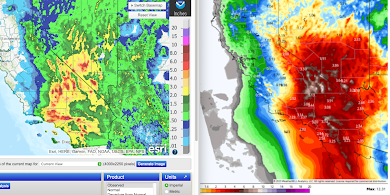
We emphasized the most serious threat was flooding. The rainfall forecasts were quite a challenge given the rarity of tropical systems over the irregular terrain of California. Overall, I think the forecasts were quite good. At left is the actual amount of rain produced by Hilary with the legend for rain amounts on the right. At right is the forecast that appeared on this blog Friday afternoon with the legend at lower left. I would call the rainfall pattern excellent and the amounts surprisingly good. While there was some overforecast of amounts in places, again, there was no experience forecasting a tropical storm in the Southwest.

I would rate the rainfall pattern an A with the amounts a B+.
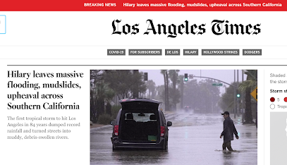
I called for the possibility of "catastrophic" flooding. Here is the current headline at the Los Angeles Times:

 |
| One of a number of urgent tweets from people cut off by Hilary |
The damage images continue to come in today and they are impressive in a number of areas. AccuWeather has a storm recap.
Finally, more than a quarter of a million people came to this blog for forecasts and storm advice. I want you to know that I appreciate your trust and faith in our forecasts. I take that trust very seriously. Just so you know, each full update pertaining to Hurricane/Tropical Storm Hilary took more than 90 minutes to prepare. Hurricane season is just getting started (south Texas is threatened Tuesday) and I'll continue to work hard to continue to provide outstanding quality forecasts throughout the late summer and autumn.


Comments
Post a Comment