
Update on Potentially Catastrophic Flooding in the Southwest
I have some important information pertaining to the flash flooding that will accompany what is forecast to be Tropical Storm Hilary when it reaches California and the Southwest. Please forward this to anyone you know in Southern California, western Arizona, southern Nevada (including Vegas) and southwest Utah.

The emphasis of this update is the potential for catastrophic flooding. 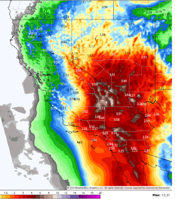
Below is a wider view of the Southwest as a whole. Generally, if you are in a red area ( ≥2"), you are in danger of flash flooding.


 Turn on "Emergency Alerts." In, in this situation, I would also turn on "Public Safety Alerts."
Along the San Diego and Orange County coasts, peak gusts of up to 70 mph are forecast to occur. However, along the mountains, wind gusts of 80-90 mph are forecasted.
As of noon Mountain time, the storm still had 145 mph winds. The image below is from 12:18pm Mountain time. [Update, 1:25pm MDT] I've added some important info regarding forecast wind speeds at the bottom.


Amounts: The above map is of California and Nevada. Rainfall amounts have been upped significantly in this latest forecast with more than ten inches forecasted in several places and a foot in the southern Sierra. If this is correct, the flooding will be catastrophic. Please keep in mind that, with Hilary, what is the dry sides of some mountains will be the wet sides in this storm.
To give you an idea of the intensity of this storm, Thermal CA (east of Palm Springs) is forecast to receive as much rain in 40 hours as it has in the last four years combined.
Timing: Significant rain will reach I-10 in the pre-dawn hours Saturday. They will reach I-40 by 10am Saturday. In coastal Los Angeles and Orange counties the heavy rain may wait until Sunday but it will be very heavy when it falls.

In addition to flooding, based on the newer track forecasts, the threat of tornadoes looks pretty high for the Southland. Make sure you have Wireless Emergency Alerts (WEA) enabled on your smartphone. That should warn you of both tornadoes and flash floods.
How to Prepare:
I recommend the following:
- Fuel your car now.
- Turn on WEA messages. Instructions below.
- Get extra cash from the ATM. If power fails, cash is king when credit card machines and ATMs do not work.
- Make provisions for infirm friends or relatives.
- Prepare a "go kit." That would include a change or two of clothes, medicines, and anything else you might need (including portable heirlooms). Be able to throw it into a car at a moment's notice if an evacuation order is forthcoming.
- Keep your smartphone and laptop fully charged. However, if you hear thunder (there could be thunderstorms in this situation), immediately disconnect the charger as a power surge could damage both.
- Might not be a bad idea to get some bleach for water purification.
- An extended period without power is quite possible (scroll down for more).
- Remember -- in floods, you want to gain altitude provided that does not involve crossing flooded areas by foot or by car. Most fatalities in flash floods are from people who are perfectly safe deciding to cross floods and being swept away.
Finally, if you live in area that has previously experienced flooding, consider leaving before the heavy rains begin.
I will have another update later this afternoon that will focus more on the wind threat in addition to the rain.
Wireless Emergency Alerts Activation
- If you have an iPhone, here is what you do. Tap "settings" (the gear-like icon) on the home page.
- Then, tap "Notifications"

- Scroll down to Government Alerts.

Important Update Regarding Winds:
 |
| Forecast Peak Wind Gusts, click to enlarge H/T Dr. Craig Cecee |
Along the San Diego and Orange County coasts, peak gusts of up to 70 mph are forecast to occur. However, along the mountains, wind gusts of 80-90 mph are forecasted.
This has a couple of implications: in addition to power lines being blown down, there is the potential the lines will be de-energized in the wake of the criticism over the Maui Fire. Of course, with heavy rain, the changes of a fire are low due to a downed line. I mention this because of the potential for widespread power outages beyond what the storm itself may cause.
Comments
Post a Comment