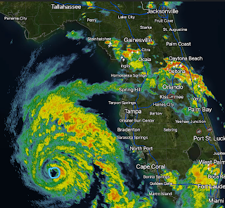
6:30pm Bulletin on Idalia - Rapid Intensification Underway
Data from weather satellite, Hurricane Hunters, and coastal radar all indicate that "rapid intensification" (RI) is underway. The pressure in the center has continued to fall to about 967 millibars.
The storm's movement is accelerating to the north. I urge you to evacuate if told to do so and, if you are outside of the evacuation areas, finish your storm preparations. Wind gusts over the Florida Peninsula are currently gusting to 50 mph as far north as Orlando and The Villages and similar, or in some cases stronger, gusts will continue the rest of the night with squalls.
This will likely be a bad one. Treat it with respect!


Comments
Post a Comment