
Hurricane Warning For Florida: Idalia, 12:25p Update
Extremely dangerous, soon to be hurricane, Idalia heads toward Florida.
The storm now has sustained winds of 65 mph and its pressure is down to 990 millibars.

H = Hurricane. M = Major Hurricane.
Maximum winds will be in excess of 115 mph at landfall. Red is the hurricane warning area. That includes Tampa Bay which may experience hurricane-force winds and will experience a storm surge. 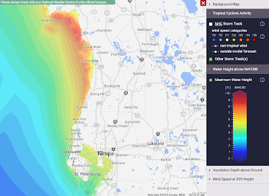
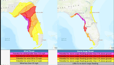 Please note that 110mph winds are possible in western part of the Tampa area, including Clearwater Beach!
Storm surge will drown you, if you are in its path. It will be 7-12', not counting tidal effects. That means if you are 6 feet tall, the water will be over your head.

Here is a breakdown of risks.


Comments
Post a Comment