Posts

Showing posts with the label Idalia

Evaluation of Forecasts of Hurricane Idalia

Image
This is our routine self-evaluation of the forecasts we present on this blue when major events occur.  The fact the forecasts for Idalia, at least as presented on this blog, were quite timely and accurate is important given some of the silly comments the last couple of days contending that hurricanes are less predictable due to global warming.  One Week Before Landfall Six Days Before and, then,  Four Days Before The forecasts unfolded normally after that time.  One forecast of note was the forecast of power outages.  That was the forecast. Here are the power outage maps as of a few minutes ago.  If anything, I underforecast the extent of the power outages. It will be days before everyone is back online.  I would rate these forecasts an "A."

11:20am Tuesday: Hurricane Idalia -- DEADLY SURGE

Image
Key West radar at 10:37am E = Eye of Idalia An eye has formed in Idalia this morning and the storm became a minimal hurricane overnight. The stage is set for rapid intensification (RI) but that has not begun as yet as the storm is still "feeling" some wind shear. Satellite indications the last few minutes indicates RI may be starting. [Quick note at 11:33am. Lightning near the center indicates that RI may be starting.] The storm should be a 125-130 mph (strong Cat 3 speed) hurricane at landfall in the Florida Big Bend.  The National Hurricane Center's forecast has pretty much focused on the Florida Big Band and I agree. [UPDATED]  The storm surge will be deadly along and to the east of the point of landfall as it will reach to a depth of 15 feet. Imagine yourself at the bottom of a 15' deep swimming pool with the water flowing rapidly. Do you think you would survive? Tampa Bay is expecting a surge of 4 to 7 feet, which is a major problem. Please note that, back of 18...

5:05pm Forecast for Soon-To-Be Hurricane Idalia

Image
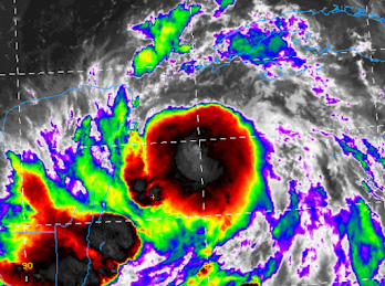
The satellite image of Idalia show it attempting to create an eye as of 4:26pm. This is a further sign of strengthening.  Wind Forecast This is the National Weather Service's digital presentation forecast of the wind gusts associated with Hurricane Idalia.  Please note the proximity of 70 mph wind gusts to Tampa Bay. There will already be a storm surge into the bay but if either the wind field should enlarge or the storm take a track even slightly farther east, then then conditions may be worse than forecast.  Below is the earliest likely time of arrival of 40 mph winds.  H = Hurricane. M = Major Hurricane. S = Tropical Storm. Anyone in the hurricane warning (red) area should be prepared for winds of 70 mph or stronger.  Storm Surge Forecast Storm surge warnings are in effect! Life-threatening surge likely.  From the National Hurricane Center: Inundation of 8 to 12 feet above ground level is expected somewhere between Chassahowitzka and Aucilla River. Resi...

Hurricane Warning For Florida: Idalia, 12:25p Update

Image
Extremely dangerous, soon to be hurricane, Idalia heads toward Florida.  The storm now has sustained winds of 65 mph and its pressure is down to 990 millibars.  H = Hurricane. M = Major Hurricane.  Maximum winds will be in excess of 115 mph at landfall. Red is the hurricane warning area. That includes Tampa Bay which may experience hurricane-force winds and will experience a storm surge.  Storm surge will drown you, if you are in its path. It will be 7-12', not counting tidal effects. That means if you are 6 feet tall, the water will be over your head.  Here is a breakdown of risks.  Please note that 110mph winds are possible in western part of the Tampa area, including Clearwater Beach! There is a tornado risk, which is highest in the brown area.  There will be localized flooding. However, the area has been in a mild drought which should work to mitigate the worst of the flooding possibilities. 

Extremely Dangerous [Eventual Hurricane] Idalia Headed For Florida

Image
[Scroll up for more current information. Thank you.] There is no doubt in my mind that Idalia will be  a  major hurricane at the time of landfall.  The deep red above is what meteorologists call a "wind swath," which is the highest wind gusts along a hurricane's path. It is too soon to know the exact path but, if you are between the two arrows and you are told to evacuate, DO IT.  There will likely be a devastating storm surge.  There will be a compete update between 11 and 11:20am, after the NHC releases the latest information. 

9:40 pm EDT Special Update: Idalia, A Bit Stronger

Image
[Scroll up for more current information. Thank you.] I want to update you before your retire for the night. As of 9:40pm, trends continue in the wrong direction.  The inner core development (immediately below) continues. A nearby buoy is measuring rapidly falling barometric pressure. This strongly implies that strengthening is occurring more quickly than forecast.  Two more ensembles of models have come in and they, too, forecast a path a little farther to the east.  Given the above, it would not surprise me if hurricane warnings for the west coast of Florida and/or western Cuba were issued later this evening. Regardless, it is absolutely essential for those in the hurricane watch and  the caution zone (below) to prepare for the potential  (not certainty) of major hurricane conditions.  [ --- original text, still valid ---] I don't like the trends I am seeing with Idalia. Satellite seems to be showing the storm developing an inner core a bit sooner than exp...

5:20pm Idalia Update

Image
S = tropical storm. H = hurricane. The National Hurricane Center's (NHC) path is within the white "cone." The pink is a hurricane watch and yellow is a tropical storm watch. I continue to caution the entire south extent of the watch area to keep a close eye on the progress of what will very likely become Hurricane Idalia (red arrow).  The new storm surge maps are not available but they should be similar to the one in the posting below. NHC is now forecasting a storm surge up to 11 feet along and just to the east of where the eye makes landfall. Tornadoes will be likely, especially north of Alligator Alley and east of Tallahassee.  Here is the latest rainfall amount forecast.  "The Cone" is an unfortunate name for the area outlining NHC's risk envelope for the path of the eye. An explanation is below.  I would call it, "the zone" but that is just me. Please note that I'm giving some extra leeway on the east side of the "cone."

Forecast for Tropical System Idalia

Image
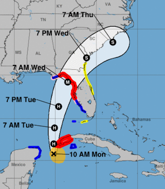
[please scroll up for more current information] As promised, I want to give my readers a first estimate of how what I believe will be Tropical Storm or Hurricane Idalia will unfold. While it is too soon to get highly specific, I believe the system near Yucatan will begin to more northeast and gradually strengthen the next few days. The center of the system will reach the coast as a tropical storm or hurricane sometime between Tuesday night and Wednesday night.  Stay tuned! Below is the first update on what they are calling 2023's Tropical Depression #10: The Hurricane Center is forecasting Hurricane Idalia  with sustained winds reaching 75 mph by 5pm Monday. Additional strengthening is likely until the storm makes landfall.  This is NHC's forecast track. S = tropical storm. H = hurricane.