10am Update on Ian
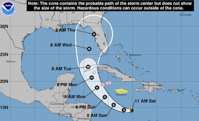
The Hurricane Center has nudged the path of Ian slightly to the west and north which, if correct, is bad news for Tampa Bay as it would experience a major storm surge as well as the high winds of the storm. They have also increased the landfall wind speed to 120 mph -- a major hurricane. However, it is important to realize that the path forecast could certainly change between now and Thursday. The reason for this latest change in landfall time isn't due to a change is speed of the storm but rather a longer path to land in Florida.
Note that the hurricane watch for Grand Cayman Island will likely be changed to a warning as Ian is expected to be a hurricane with 100 mph winds as it passes near the Island.
Some suggestions for this point in the storm's progression:
- If you get a portable generator, follow the instructions to the letter! In Hurricane Laura, more people died from carbon monoxide poisoning than from the hurricane itself.
- Get extra cash from the ATM.
- Make sure your vehicle is filled with fuel now -- before the rush begins.
- Pack a "go kit" so you can make a rapid getaway if an evacuation is ordered. It should include some basic clothes and any small heirlooms or other valuables.
Flooding rains are likely in Florida.
More to follow this evening.


Comments
Post a Comment