
National Hurricane Center's Update, 11pm Tuesday


Damaging winds are likely inland into the Disneyworld-Orlando areas or just to the south. There will be near total power failures throughout this region back west to the coast.
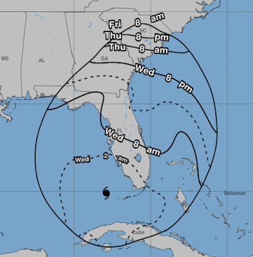
Note: As shown in the upper map, Ian may restrengthen once it gets back out over the Atlantic and may produce wind damage in Georgia and/or South Carolina.
The map below shows the times by which your precautions need to be complete.

There is an enhanced tornado risk in the south half of Florida tonight and throughout the Peninsula tomorrow.
Please see the posting below for more details.


Comments
Post a Comment