
3:45pm Update on South Central Flood Risk
The National Weather Service has further raised forecast rain amounts in Texas and immediately adjoining areas. The map is valid until 7pm CDT Friday, the 26th.  The gold area in north (including the DFW Metroplex) and parts of central Texas is where seven inches or more are predicted to fall. In addition, I would forecast 3"+ in the Lubbock and Plainview areas and from there to the New Mexico border, a little farther west than on the map.

I also believe amounts may be heavier in southwest Louisiana than indicated on the map.
As to timing, significant to heavy rains will start in west Texas during the pre-dawn hours Sunday.
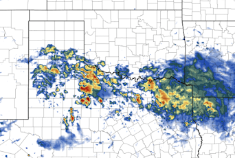
The image below is the forecast radar for 1am Monday. I believe it is a reasonable representation of the rain pattern at that time. The rain will become more widespread on Monday.

Intermittent rain and thunderstorms will become more numerous over Texas and Louisiana more or less throughout next week.
Regardless of the current drought, if you live in a flood-prone area I would make sure to have a "go kit" ready by Sunday afternoon.
Whatever you do, do not cross flooded areas by foot or by car!


Comments
Post a Comment