Tornado + Derecho/Damaging Wind Forecast
A second tornado watch has been issued for this area.
-----------
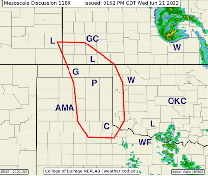
A Tornado Watch is Now in Effect Part of the Southern High Plains
The NWS SPC forecast that this will be the area of initial thunderstorm development, probably around 4 or 4:30pm.
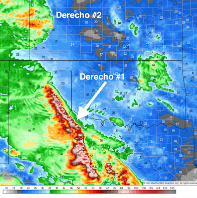
When the storms develop, they may produce large or giant hail (4" forecasted) or even tornadoes. It important to start monitoring local weather information around that time. Here's the problem: the models are showing two different paths of the derecho (a long-lived swath of damaging winds) that is forecast to develop from the initial thunderstorms in the red area above. And, a second derecho is forecast to develop late tonight in Colorado.
Some of the models are forecasting wind gusts of 90 mph or stronger with these storms. Saturday night's derecho caused more than 1 million people to lose power. They are still cleaning up that mess so, if power is lost tonight or tomorrow, it may be days before it is restored.
So, I cannot tell you exactly where the damaging winds or tornadoes will occur. That is why you absolutely should have at least three independent means for receiving the warnings. I personally testify that StormWarn works great! Make sure you also have WEA turned activated on your smartphone. These two will wake you up if there is danger so you can retire for the night with confidence. Also, an app like AccuWeather's a great choice.
So, I urge you to prepare now!
Safety Recommendations...
- Call friends and relatives to make sure they are aware of the threat, especially if they live in a mobile home.
- Make sure you have at least three ways of receiving storm warnings.
- If you live in a mobile home, you may wish to move spend time with a friend or relative given the 90 mph wind forecast plus tornado thr5eat.
- Ask yourself what you would need if you were without electricity for five days. In some areas it will be longer, but five days is a good planning target.
- If you have a chain saw, fill it with fuel.
- Check your tornado shelter. Make sure it has a couple of bottles of water and, if appropriate, diapers.
- Any essential foods or medicines should be taken care of immediately, well before the storms arrive.
- Have all of your devices charged but disconnect when you see the first lightning or hear the first thunder.
- Keep the kids in close communication.
- Bring in lawn furniture, trampolines or anything else that can blow away.
- Put the car in the garage.
- Pick any ripe tomatoes.
- Do laundry in case of extended power failures (quite likely in a derecho)
- Battery-operated fans for the same reason (it will be quite hot the next few days)
You can also follow more for more on Twitter @usweatherexpert.


Comments
Post a Comment