
5:35p Tornado and Derecho Update
Here are the regional radar images as of 5:25pm.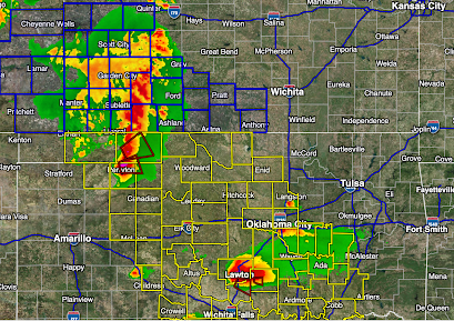


Color code:
- Maroon, small polygons = tornado warnings at that time.
- Yellow county outlines = tornado watches.
- Blue county outlines = severe thunderstorm warning with gusts to 75mph and a lesser chance of tornadoes.
We've received reports of "significant damage" in Perryton, Texas. Multiple tornadoes have already touched down.
The derecho potential continues to be very serious with a reliable model continuing to forecast that it will produce at least a few peak gusts of 100 mph or even stronger -- meaning major, multi-day power outages.
Safety Recommendations:
For more, follow me on Twitter @usweatherexpert.
If you would like to learn how the tornado and derecho warning system works, go here.
Finally, I'm repeating the safety suggestions we have written about several times today:
- Call friends and relatives to make sure they are aware of the threat, especially if they live in a mobile home.
- Make sure you have at least three ways of receiving storm warnings.
- If you live in a mobile home, you may wish to move spend time with a friend or relative when a tornado or severe thunderstorm watch is issued.
- Ask yourself what you would need if you were without electricity for five days. In some areas it will be longer, but five days is a good planning target.
- If you have a chain saw, fill it with fuel.
- Fill your generator with fuel and, if portable, make sure it is located a long way from air intakes such as your air conditioner. See instructions that came with the generator.
- Check your tornado shelter. Make sure it has a couple of bottles of water and, if appropriate, diapers.
- Any essential foods or medicines should be taken care of immediately, well before the storms arrive.
- Have all of your devices charged but disconnect when you see the first lightning or hear the first thunder.
- Keep the kids in close communication.
- Bring in lawn furniture, trampolines or anything else that can blow away.
- Put the car in the garage.
I'll update in the mid- to late afternoon.
Additional suggestions from Liz Leitman at SPC:
- Pick any ripe tomatoes.
- Do laundry in case of extended power failures (quite likely in a derecho)
- Battery-operated fans for the same reason (it will be quite hot the next few days).
This will be the last blog forecast on these storms. I'll have hour-by-hour updates on Twitter.
More severe thunderstorms likely on Friday and Saturday. Of course, I'll provide coverage tomorrow.


Comments
Post a Comment