
Labor Day Tornado Warning and Thunderstorm Threat
3:46pm Update.
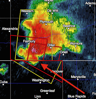
No sooner did I get the below posted was the warning extended into Kansas. The arrow points to the likely location of the tornado as it moves ESE. Take cover in the red polygon!
ORIGINAL POSTING:
As of 3:35pm radar, there is a tornado warning near Fairbury, Nebraska (red polygon), and thunderstorms rapidly developing in central Kansas. I have included the lightning data
 If you have friends on area lakes, I recommend getting off the lake at the very first sign of the approach of a thunderstorm.
In spite of the tornado warning, the NWS has issued a severe thunderstorm watch until 9pm for the Kansas-Nebraska border area as outlined below.
 A severe thunderstorm watch is a forecast of damaging thunderstorm winds and large hail.
No sooner did I get the below posted was the warning extended into Kansas. The arrow points to the likely location of the tornado as it moves ESE. Take cover in the red polygon!

ORIGINAL POSTING:
As of 3:35pm radar, there is a tornado warning near Fairbury, Nebraska (red polygon), and thunderstorms rapidly developing in central Kansas. I have included the lightning data
(the "zot" symbols) on this image.

In spite of the tornado warning, the NWS has issued a severe thunderstorm watch until 9pm for the Kansas-Nebraska border area as outlined below.


Comments
Post a Comment