
Yesterday's Tornado Warning Failure in Florida

There is an exceptional number of exceptional close-up videos of yesterday’s Palm Beach Gardens (PBG) Tornado. After seeing the ever-increasing number into this afternoon I thought, “Why weren’t they taking cover?” Based on a quick look yesterday, it appeared the tornado warning was timely. Unfortunately, it turns out it was not.
Now that the National Weather Service’s (NWS) survey of this strong tornado (EF-2 intensity) is complete, it is important to note that the tornado warning was not issued until the tornado had been on the ground for two minutes. The NWS's goal is for the tornado warning to be issued 13 minutes in advance, so this warning fell far short. Fortunately, there were no injuries.

Of course, it is not possible to issue a tornado warning in advance of all tornadoes. Such is the state-of-the-science. But, there are many reasons to believe there could have been advance warning of the PBG tornado – about ten minutes’ worth. This is especially important as this tornado cut through a densely populated area.
The West Palm Beach region is served by multiple radars. Unfortunately, the primary National Weather Service (NWS) radars are rather distant: The Miami radar is 87 miles away and the Melborne radar is 98 miles. The NWS office responsible for warning West Palm Beach is the Miami office and, unfortunately, they were not running their radar in the proper mode for tornado conditions: The radar was updating at only 4-minute intervals. The more distant Melborne radar was being operated properly with updates every 1.2 minutes, which is the best possible. Running the radar at the wrong interval during tornado situations has become a frequent problem across the NWS.
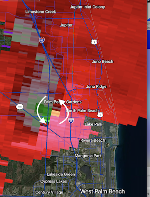 |
| Miami National Weather Service radar showing strong rotation at 5:02pm EDT. |
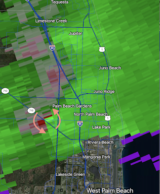 |
| Melbourne National Weather Service radar showing moderate rotation farther southwest than Miami's at 5pm. |
Why is the interval important? Tornadoes can form quickly as they did yesterday. The Melborne radar indicated a tornado warning should be issued because of “gate-to-gate” (highly concentrated) Doppler wind rotation at 5:00pm EDT. The key radar, Miami’s, because of the less frequent updating, did not indicate the tornado warning was needed until 5:02 EDT. Still that would have been eight minutes before the tornado formed. It is hard to understand why this wasn’t done.
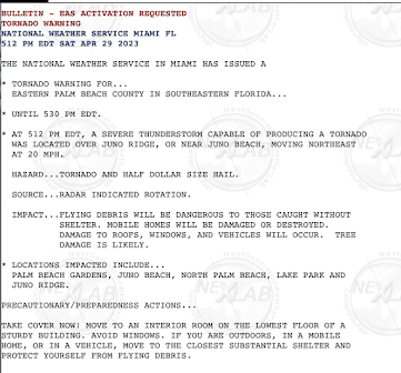 |
| The tornado warning for Palm Beach Gardens that was issued at 5:12pm EDT. |
Gate-to-gate is not the only criterion. There are several criteria meteorologists look for when deciding to issue a tornado warning. Here is how they stacked up, with one exception, as of 5:00pm.
- General meteorological conditions favorable for tornadoes. Present. Tornado watch in effect.
- Right-moving supercell (radar). Present
- Jump in lightning activity (satellite) as of 5:06pm. Present
- Enhanced Vee (satellite). Present
- Doppler wind velocity couplet (radar). Present
- Hook echo (radar). Not present until after the tornado formed.
 |
| Lightning jump as seen from GOES weather satellite at 5:06p |
In other words, by 5pm, this was a straightforward warning situation. Yet, the warning was not issued for another twelve minutes, two minutes after the tornado touched down. I believe a timely warning would have been issued in, say, 2008 in an identical situation.
Yes, I am saying the NWS's tornado warning program, rather than improving, has deteriorated in the past 15 years.
There seem to be three issues plaguing the NWS’s tornado warning program.
1. Retirement of my generation of meteorologists. The experience of learning how to issue tornado warnings with black and white, non-Doppler radar progressing into the Dopper era, then adding satellite data cannot be replicated. Experience cannot be taught.
2. The NWS’s relatively recent emphasis on reducing false alarms -- without providing any proven scientific techniques for doing so. False alarms have gone down by 2% -- while the accuracy of tornado warnings has gone down 14%. Lead time, the interval from when the warning is issued to when the tornado forms, has dropped from a nearly ideal 13.3 minutes to just 8.4 minutes.
3. Some NWS local offices appear to have made the tornado warning process too complicated.
The National Weather Service used to investigate its performance after major disasters through what it called, "Service Assessments (SA)." However, for all intents and purposes, the NWS has stopped doing them except in rare situations. The last Why? Because most of the problematic meteorological situations of the past five years have featured issues with the NWS's performance. Thus, there was a SA for 2021's Hurricane Ida (not released until April 2023!), where the NWS did well, but not a Service Assessment for 2022's Hurricane Ian, where the NWS's performance left a lot to be desired.
Congress has been holding hearings on the topic of making the National Oceanic and Atmospheric Administration (NOAA) an independent agency. Now, it serves under the Department of Commerce. While I am not aware of Commerce’s attitude toward the NWS under the Biden Administration, under the Trump Administration Commerce knew there were serious problems. Regardless, we have yet another head of NOAA with no background in weather – which has been continuously the case since 1974!
So, I do not support making NOAA an independent agency unless – simultaneously – Congress creates a National Disaster Review Board (NDRB) modeled after the National Transportation Safety Board (NTSB). The NDRB would not just review the performance of NOAA, it would look at FEMA, the Red Cross, and state and local entities, both public and private sector. And, like the NTSB, it would make recommendations to the agencies, Congress and the President as to what went well and what did not, with suggestions for improvement.


Comments
Post a Comment