
Paths of St. Louis / Bi-State Tornadoes
We had a number of rotation paths that may have produced small tornadoes in the St. Louis - Bi-State area earlier this evening.
 |
| Rotation path map. Red-White-Blue > chance of an actual tornado |
At lower left, the circle shows the rotation around Leslie, MO where a tornado occurred this afternoon.
In the Bi-State area, the arrows indicate the rotation paths over the area. Because the storms were moving so quickly (50+mph), the paths are not as precise as usual. From radar, it would appear the most significant rotation was between Ladue and Olivette and up the river from just east of Lemay to downtown.
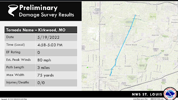
UPDATE 9:15pm: NWS graphic of the path of the Kirkwood Tornado, which corresponds to the easternmost of the cluster of 3 arrows.

These situations are really difficult because they feature quick spin-ups and the NWS had the radar on 3.5-minute mode, so some of the spin-ups occurred between radar scans. I wish more NWS would go to the 1.3-minute mode in tornado situations.
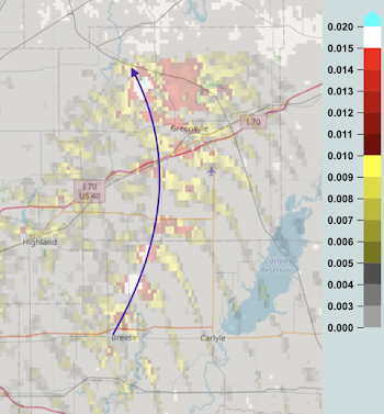
Farther east into downstate Illinois there is a was a significant rotation track from north of Breese to northwest of Greenville.

Comments
Post a Comment