
Major Winter Storm: Interior Northeast
In this case, let's begin with the NWS's experimental winter storm index. Click to enlarge. 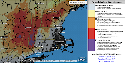 Note that extreme effects are forecast for the Hudson Valley and parts of interior New York. Click to read the importance of that category.
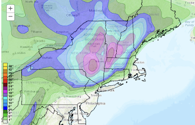

The primary snow will begin Monday night and Tuesday. Amounts will be extremely heavy in parts of the area driven by wind gusts up to 40 mph in the Lower Hudson Valley. There will be blizzard conditions at times. Note: Major snow accumulations are not expected in NYC.

Because this will be a heavy, wet snow with high winds, power failures are likely.
It is essential to prepare:
- Fill your car with fuel. Fully charge your laptop and smartphone but taken them off the charger before high winds begin: power surges can damage both.
- If you have a generator, fill it with fuel but make sure it is far away from the house and not near air intakes.
- Make provisions for infirm friends and relatives now.
- Get groceries and other essentials tomorrow. Stores will likely sell out as the storm gets closer.
- Get any prescriptions refilled.


Comments
Post a Comment