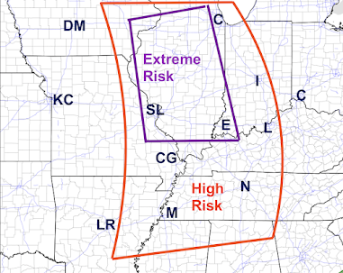
Extreme Risk of Tornadoes and Damaging Winds Friday and Friday Night
8:40am: These forecasts still look good.
Tornado Risk from 11am until 4am Saturday
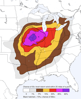
Damaging Wind Forecast From 10am Friday until 7am Saturday
 |
| Nadocast.com |
The hatched purple areas is where thunderstorm-generated straight-line winds of 75 mph or stronger are forecasted to occur. The red area is where there is an enhanced risk of wind gusts of 60 mph or stronger.
There will be widespread power outages in these areas!!
If a tornado warning is issued, or if a warning for wind gusts of 70 mph winds or stronger is issued, take shelter in the basement, preferably under a pool table or heavy furniture or, if you have a finished basement, in a closet or bath.
If you do not have a basement, a small closet or bath on the lowest floor is the place to go as in the photo below.
Recommended safety suggestions:
Make sure you have at least three ways of receiving storm warnings from the list below:
- Weather Radio
- Wireless Emergency Alerts (enable by going to "notifications" on your iPhone and scroll down)
- Phone Alerts
- Weather Apps (AccuWeather's with "locations" enabled) is free and a good choice
- Make sure family and friends are monitoring the weather, also. Call them.
- Make sure you can get family, especially infirm members, to shelter quickly if a tornado warning is issued.
- If you live in a mobile home without a community shelter, seek other shelter if, 1) a tornado watch is issued, and 2) thunderstorms are forming to your west
- If you have a motorcycle, football or other helmet, wear it into your shelter.
- Insure your shelter area is ready to go. A flashlight, a couple of bottles of water, diapers, radio or TV, and always wear shoes into your shelter.
- If you are short on prescriptions, get them refilled asap.
- Fill/charge your chainsaw.
- Fill/charge your automobile.
- Charge your smartphone and laptop but take them off the charger when thunderstorms approach.
I will be providing additional live weather information on Twitter @weatherexpert.


.png)


Comments
Post a Comment