
More NWS Tornado Warning Issues -- This Time in Dallas
Investigative Report
© 2023 Mike Smith Enterprises, LLC

I have reported many times about how the current issues with the National Weather Service's tornado warning program are costing lives (examples here and here) and preventing people from doing what they can to -- when possible -- mitigate damage.
Because I have been asked, let me I assure you that I have discussed the issue with NOAA meteorologists and management on a number of occasions -- as recently as earlier today. The best way to describe their reaction is that they are in denial.
Because NOAA has stopped doing after-incident "Service Assessments" where they lightly reviewed their performance after a major event, and because it isn't a good idea for NOAA/NWS to be investigating itself, I have been calling since 2012 for a National Disaster Review Board similar to the hugely successful National Transportation Safety Board. This is another event where the Review Board would have been helpful.
Thursday afternoon, there was a tornado in the western suburbs of Dallas for which the warning was late quite late. I will walk my valued readers, especially meteorologists, through this case history. It is especially important because the FAA's Terminal Doppler Radar for Love Field did a better job of detecting the the tornado than the NWS's WSR-88D, at least the way that radar was operated Thursday afternoon.
Because it was explicitly designed to detect winds, and because they update at one-minute intervals, the TDWR's often detect tornadoes more quickly than -88'D's. I find them them to be great radars for detecting tornadoes, downbursts and other forms of damaging winds.
As with the south Kansas City tornado of June 8, 2022, the NWS was operating its -88D in a less-than-optimal mode for the situation. An NWS radar can update as often as every 1.4 minutes. But, yesterday afternoon, it was operated in the three-minute mode (KC had it in 7-minute mode). I'm not sure why NWS offices do not automatically switch to rapid updates when a supercell is present, especially in a densely populated area, during a tornado watch.
Here is the radar/warning comparison:
FAA's Terminal Doppler Radar
Love Field Data


At right, the tornadic rotation has strengthened considerably. In my opinion, a tornado warning should have been considered at this point.

At 4:51, if you click and enlarge, you'll see the hook is becoming better defined. The tornado rotation at right has become quite well defined. The red/green "couplet" has become so bright in the green I didn't think it needed to be circled. If I had been on the WeatherData, Inc. storm warning desk, no question I would have issued a tornado warning for our clients at this point.
Because I believe, when the general public is involved, the term "tornado warning" should be reserved for the National Weather Service, I tried to get a warning message across at this time. The radar used in the Tweet (below) used the WSR-88D which we will come back to.


4:52pm, the hook is now mature with strong rotation. Given the radar is close to the storm (meaning the radar is scanning the storm near the ground, where the tornado occurs), there is almost certainly a tornado at this point.
National Weather Service WSR-88D Radar Data
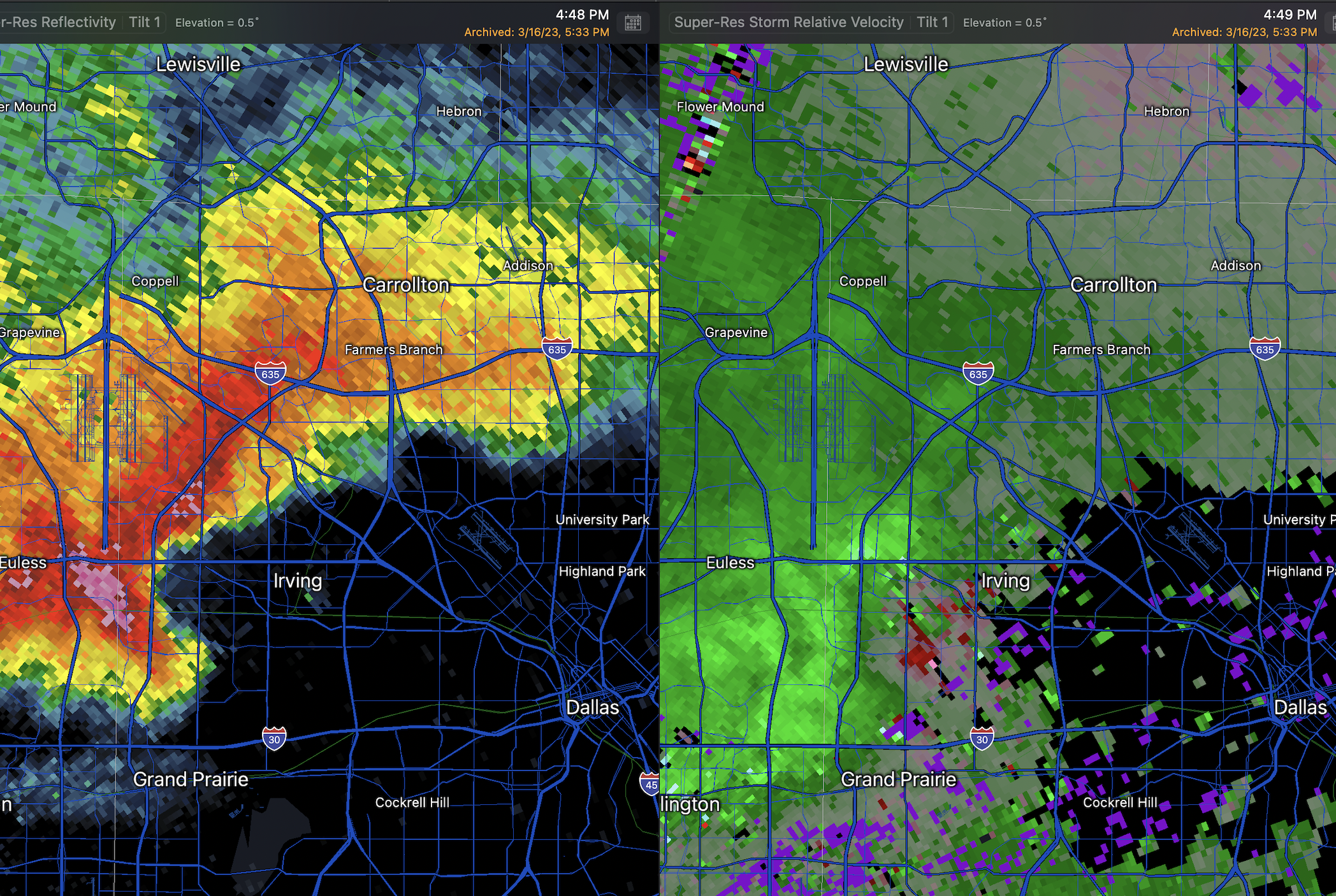

At 4:51 (reflectivity) and 4:52pm (velocity), the hook echo is quite pronounced with good rotation. As with the TDWR data, if had been all I had, I would have issued a tornado warning at this time.

4:54 reflectivity and 4:55pm rotation clearly shows a tornado given the above plus the general atmospheric conditions.
I was still very concerned about a tornado. Since there was no tornado warning, I tweeted this at 4:56pm.


As of 4:56 reflectivity and 4:57pm rotation, the hook appeared to be in its weakening stage (known as "occlusion") and the wind couplet is less defined as he greens and reds have a gray space between them rather than against each other.
There is no question the FAA's TDWR outperformed the NWS's WSR-88D yesterday.
The National Weather Service issued its tornado warning for Dallas County at 4:57pm.
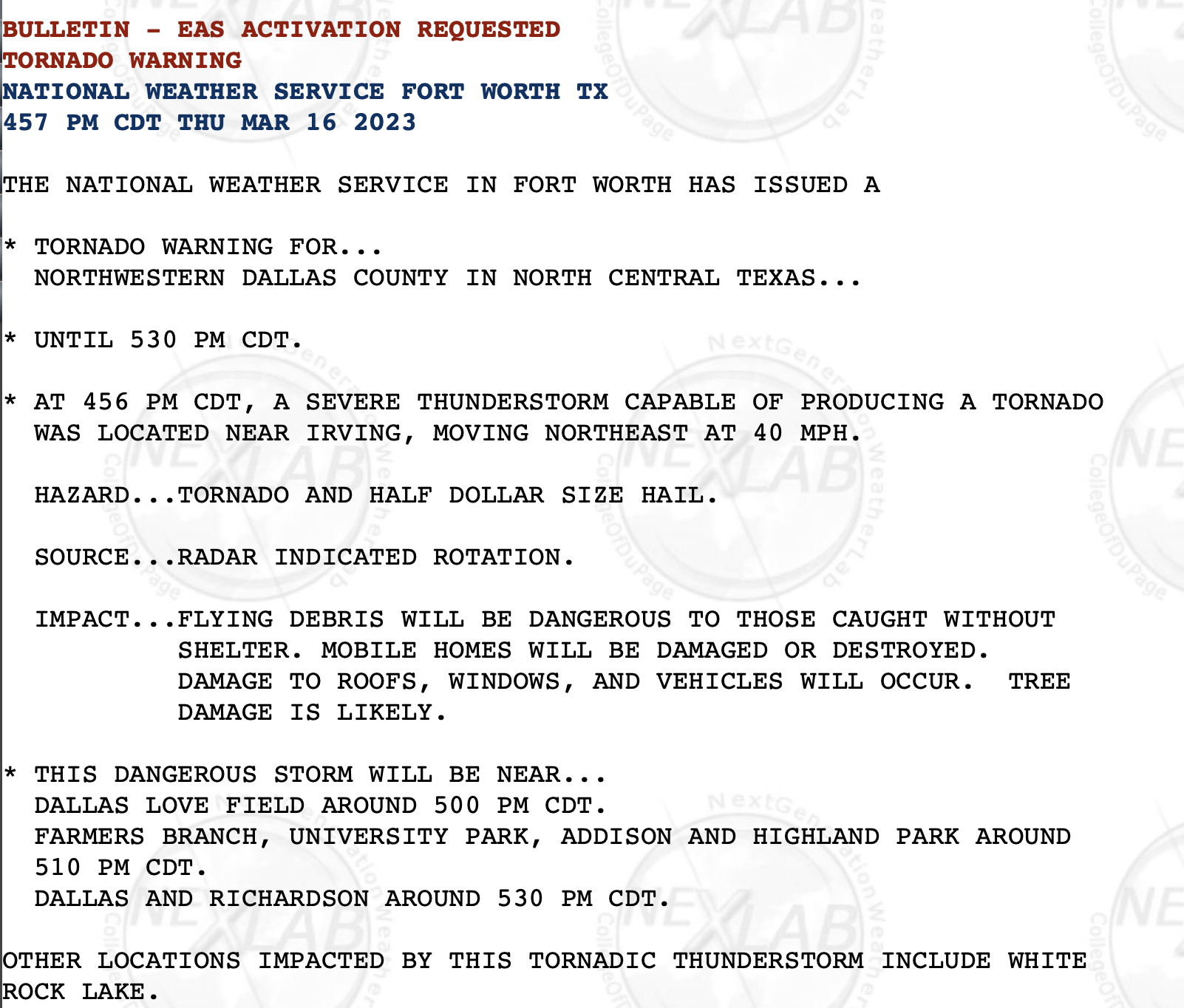
The NWS in Ft. Worth's survey teams found two tornadoes in Dallas County, both of EF-1 intensity.


- -10 minutes for Dallas County #1
- -5 minutes for Dallas County #2
NWS tornado warning "lead time" -- the interval between when the tornado warning is issued and when the tornado touches down -- was +13.3 minutes from 2005 to 2011. Since 2011, the lead time has dropped to +8.4 minutes for the years 2012 to 2020.
The "probability of detection" (the percentage of time a tornado warning will be issued before the storm touches down) went from 73.3% from 2005 to 2011 and then dropped alarmingly to just 59.1% from 2012 to 2020! Both tornadoes in Dallas Co. were "undetected."
The goal of science is to progress, but, clearly National Weather Service tornado warnings have been less accurate over the past dozen years. Because this piece is already lengthy, I don't care to go into my speculation as to why. But, it has become clearly that external pressure on NOAA/NWS is the only way that change is going to occur.


Comments
Post a Comment