Posts

Showing posts with the label Dallas

Saturday's Tornado Forecast - Updated 4pm Saturday

Image
Tornado watch valid until 10pm. Note: this does not include the DFW Metroplex. It is covered by a lesser severe thunderstorm watch but it includes the forecast, "a tornado or two possible." -- original forecast, still valid -- The brown area -- which includes the DFW Metroplex as well as Oklahoma City and vicinity -- has a significant risk of tornadoes this afternoon and tonight. Please keep up on the weather in these areas. 

Tornado Risk Throughout Monday and Into Monday Night

Image
Because there is a chance of tornadoes Monday morning, as well as during the more frequent afternoon and evening hours, I'm posting this special tornado outlook.  There is an enhanced risk of strong  tornadoes in the yellow hatched area. This includes Table Rock Lake in Missouri and Bull Shoals in Arkansas.  It also includes Gainesville and Sherman as well as Dallas in Texas. The unhatched yellow area (Missouri) includes Ft Leonard Wood as well as Lebanon. It means there is an enhanced risk of tornadoes, generally of lesser intensity. The brown area = significant chance of tornadoes, including Mexico and Boonville (MO), Pittsburg (KS), the rest of the DFW Metroplex, and Tyler and Lufkin. During the morning hours, if you are in this area and live west of I-35, it will be important for you to keep up on the latest local weather warnings.  For the rest of the area, the threat will be enhanced during the afternoon and nighttime hours.  Of course, I will update in th...

Today's Tornado and Severe Thunderstorm Risk -- Updated 2:45pm

Image
The area outlined in red will see a tornado watch issued in the near future. This includes Tulsa, Dallas-Ft Worth and Waco. Please monitor the weather in this area the rest of the day. Original Post: The area in brown has a significant risk of tornadoes today. There is also the risk of giant hail (larger than 2") in the hatched area. The enhanced risk is in red.

Overnight Tornado Forecast Update 8:50pm CDT

Image
After another eight hours, this ends my coverage for the night. Below are forecasts for the remainder of the night, please look them over.  Tornado Forecast for the Rest of the Night In the red, there is a high  risk of tornadoes, some strong, between now and 1am The yellow hatched area is where there is an enhanced  risk of strong tornadoes the rest of the night.  The brown area has a significant risk of tornadoes until 7am Thursday New Tornado Watch Until 3am CDT Thursday This is one of the most extraordinary radar images I've ever seen. This is the Dopper wind velocity data for the east half of Tennessee and far northern Alabama. I've the circled the rotation for each of the tornado warnings (red polygons).  809p CDT Severe thunderstorm and tornado risk increasing as more storms from from around Dallas to points northeast. Please monitor the area in the red outlined area.  Above is the radar and tornado watches (amber) as of 7:10pm. Storms are...

[1:10am Update] Tornado Forecast for Rest of the Night

Image
Thank you  for coming to read my tornado coverage from Saturday and Saturday night. As there were about 100,000 brand new readers, please allow me to introduce myself. I the retired Sr. VP of AccuWeather Enterprise Solutions and retired Fellow of the American Meteorological Society. Specialized for 50 years in extreme weather forecasts and warnings. I invite you to bookmark this site:   https://www.mikesmithenterprisesblog.com/    Timely forecasts of tornadoes, floods, blizzards and hurricanes are provided. On slower weather days we talk about global warming, science and issues of interest to society. On Sundays, we usually lighten things a bit. For real-time storm warning bulletins, you can follow me here:   @usweatherexpert .  Thanks again  for reading! ---Last night's Coverage --- After 16 straight hours, I must call it a night. All of the information below is current as of 1:10am. Thank you for reading and goodnight.  As of 12:35am, much of s...

See You Tomorrow

Image
I'll be speaking at Love Field's Museum of Flight at 11am.  Bring your copy of Warnings  and I'll be happy to autograph it for you. 

Please Come See Me in Dallas!!

Image
I'll be appearing at Love Field's  Frontier's of Flight Museum  on Saturday, May 6.  I'll be speaking about downbursts at 11am. If you have a copy of one of my books, I'd be happy to autograph it for you. I'll also have copies of  Warnings  for sale. The price will be $20, including tax. More here: The list of speakers is below. Note the great prizes.  Really looking forward to seeing everyone Saturday!

More NWS Tornado Warning Issues -- This Time in Dallas

Image
Investigative Report © 2023 Mike Smith Enterprises, LLC I have reported many times about how the current issues with the National Weather Service's tornado warning program are costing lives (examples here and here ) and preventing people from doing what they can to -- when possible -- mitigate damage.  Because I have been asked, let me I assure you that I have discussed the issue with NOAA meteorologists and management on a number of occasions -- as recently as earlier today. The best way to describe their reaction is that they are in denial.  Because NOAA has stopped doing after-incident "Service Assessments" where they lightly reviewed their performance after a major event, and because it isn't a good idea for NOAA/NWS to be investigating itself, I have been calling since 2012 for a National Disaster Review Board similar to the hugely successful National Transportation Safety Board. This is another event where the Review Board would have been helpful. Thursday af...

What Dallas Drivers are Dealing With

Image
Driving is not recommended -- at all. 

Attention Meteorologists and Climatologists

Image
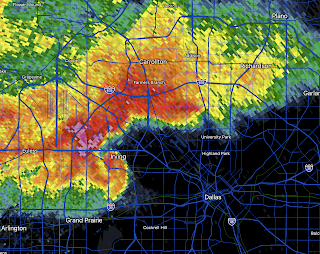
Suppose you were in this crash... And, while the paramedics were putting the seriously injured you into the ambulance, an attorney ran up and tried to shove a business card into your (broken) hand and started to explain all the grounds you had for a lawsuit: improperly maintained road, poorly designed air bags, et cetera. Would you appreciate the attorney's actions? Now, let's assume that, instead of an attorney, it was a meteorologist who ran up to you on your gurney and told you all of the ways that climate change contributed to the accident. Do you think he would win any friends? Or, would it be better to wait until the crisis was over? During yesterday's fatal flash flood in Dallas, a number of meteorologists began tweeting about the alleged relationship between global warming and the flash flood -- even as, simultaneously, news reports were explaining that people were being pulled out of cars.  To me, these are mildly unseemly, not because of their message, but becaus...

More National Weather Service Warning Issues

Image
Winterset, Iowa, fatal tornado, March 5 On March 5 , as strong to violent tornadoes roamed the Iowa countryside, National Weather Service (NWS) tornado warnings were delayed by as much as nine minutes  due to a cable cut in .... Dallas.  The red rectangles indicate the radar is out of service. The radar data shown as from a radar 100+ miles away. Yesterday, and the day before, as much as 15 inches of rain fell in Dallas with severe flooding and the loss of at least one life. Because of a NWS data outage, warnings for Dallas had to be issued by NWS offices as far away as Nashville. This outage affected the NWS radar and both of the Federal Aviation Administration radars.  Addition: 9a Friday: In addition to at least one death, six billion  dollars in damage -- and the local storm warning infrastructure failed completely! Original Article Even worse: additional Texas radars were out of service for reasons unknown yesterday.  Issuing warnings during periods of lif...