
UPDATED: Tornado, Damaging Wind and Giant Hail Forecasts
Tornado Risk

While this is certainly not a favorable forecast and caution is still necessary, the tornado risk appears a little less than it did last night and this morning. The low pressure center in the upper atmosphere is moving more east, as opposed to northeast.
In my 4-point risk category:- Yellow + hatching = enhanced risk of tornadoes. Some could be EF-2 or stronger.
- Brown = significant risk of tornadoes.
Damaging Winds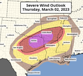
Giant Hail Wind Risk
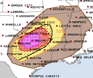 Unfortunately, the probability of giant hail has gone up. The hatched area is where hailstones ≥ 2" are forecasted to occur. Elsewhere, without hatching, 1" hail is forecasted.

The hatched area is where wind gusts of 75 mph or stronger are forecast to occur. The unhatched area may see winds of more than 60 mph. The geographic size of the 75+ mph area has been reduced since earlier today.


Comments
Post a Comment