Report on Last Night's Horrific Tornadoes
Twenty-six people perished in last night's horrible tornadoes. The aim of this report is to put these storms in perspective.
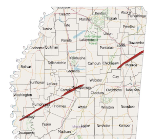
Update: Here is an updated map from Mississippi Emergency Management.
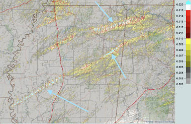
It compares nicely to the radar track estimate (above).Both from radar and from photos of the damage, I'm certain this will be at least an EF-3 intensity tornado. It is possible it will be a 4 or 5. I base the latter on its appearance on radar and its resemblance to other violent tornadoes. The NWS will have the final word after they do their damage surveys which will take days.7:50pm Saturday: The NWS has given it a preliminary rating of EF-4.
 |
| AccuWeather |
The National Weather Service did a fine job with this event. There were accurate tornado forecasts the day before and the day of, plus the warnings were timely. Storm chasers were tweeting live photos of the tornadoes from the field. Storm chasers Reed Timmer and Ryan Hall transported victims to hospitals before other first responders arrived! A number of storm chasers are licensed EMTs and they went into damaged areas.
I estimate that, absent the forecasts and warnings, more than 150 people would have died from these storms. While it will be possible to do a better comparison when the survey data is in, this resembles the Great Plains Tri-State Tornado (a/k/a "Woodward Tornado"), that tornado killed more than 180. Weather science deserves a great deal of appreciation this morning. Instead, predictably, the opposite is occurring.
The reporting by Fox News this morning that there was "no warning" is deplorable. I'm shocked the meteorologist agreed with the news anchor. He, especially, should know better.
When people incorrectly report there was "no warning," it hurts the credibility of the warning system. I have emailed Fox News and asked them to retract the report. Addition: In case you doubt the "no warning" hurts our credibility, this was sent to a meteorologist in the region at 12:57pm.
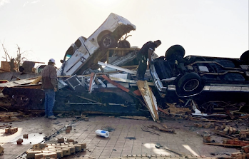
It is important emphasize that the ideal tornado warning is not an hour or similar time interval. Why? The warning would lose its urgency and people would choke highways trying to flee. As the photo above, and the video below, indicates,
cars are terrible places to be when a tornado approaches. The video, taken by storm chasers, shows the headlights of a car picked up by the tornado! I shutter to think what happened to the occupant(s).
Per research from Dr. Kevin Simmons (here and elsewhere), the ideal lead time for a tornado warning is 13 to 15 minutes. Fatalities increase beyond 15 minutes. In Dr. Simmons' words,
...lead times longer than 15 min increase fatalities
compared with no warning.
Beyond about 15 minutes warnings lose their urgency. People without basements will only stay in bathtubs and dark closets for so long.
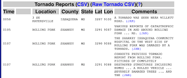
So, since some in the national media have mentioned the alleged lack of warning for the town of Rolling Fork, let's look at those warnings.
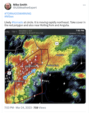
My, and the National Weather Service's, first warning for Rolling Fork was at 7:53pm. The reason I spend hours in a situation like this is so I can add the radar and other information to improve situational awareness for the warnings.
Here is the NWS's warning:Per the official list from the Storm Prediction Center, the tornado arrived in Rolling Fork at that exact time.
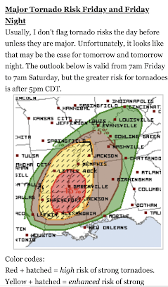
So, the people of Rolling Fork had 13 minutes of advance warning which is nearly ideal. There were many follow-up messages for that city. The warnings were excellent as the tornado moved northeast. Not only were the tornado warnings excellent, the advance forecasts were quite good. The forecast of "high risk of strong tornadoes" was posted on this blog more than 36 hours in advance.
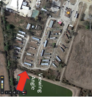
One final point I have to make is that a mobile home doesn't stand a chance in tornadic winds of this nature.
David Rouecne posted the following images to illustrate that point. The photo below shows a mobile home park in Rolling Fork.
Below is how the mobile home park appeared this morning.
Obviously, no one could survive without injury. We emphasize, over and over, that people in mobile homes should find other shelter when:
- They are in a tornado watch
- Thunderstorms start forming to their west
They can't wait until a tornado warning is issued. In 2013, I presented a paper at an American Meteorological Society meeting suggesting changes in the tornado watch program that would better address the situation where additional warning time is needed. I believe those suggestions still need consideration.





Comments
Post a Comment