
Hurricane Dorian, Update, 2:25pm Wednesday
I strongly urge people living on or near the Florida east coast to begin preparations for a major hurricane late in the Labor Day weekend.
Dorian has officially been upgraded to hurricane status as of 2pm. Its wind is 75 mph sustained, with higher gusts, with a central barometric pressure of 997 millibars. The storm is getting better organized by the hour, unfortunately.
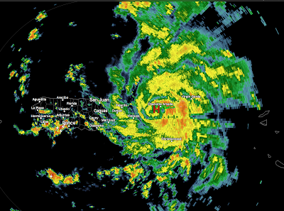
At 2:02p, the developing eye of Dorian is east of Puerto Rico at the "H." It is moving WNW and likely will not pass directly over the PR which mean intensification can continue.
With the latest model information, it is increasingly likely the landfall will be on the Florida Atlantic Coast. The latest ECMWF model, in my opinion the best hurricane model, is now more intense and slower than its most recent run. The image below is the latest ECMWF run, just in. Do not focus on its exact location. The eventual landfall could be hear or some miles to the north or south.
 There is a possibility it will move into the Gulf and redevelop but that is far too soon to determine for sure.
The posting below has what I believe are a number of valuable suggestions to be acted on, especially if you live in a county along the coast between Miami-Dade and St. Augustine.
Dorian has officially been upgraded to hurricane status as of 2pm. Its wind is 75 mph sustained, with higher gusts, with a central barometric pressure of 997 millibars. The storm is getting better organized by the hour, unfortunately.
At 2:02p, the developing eye of Dorian is east of Puerto Rico at the "H." It is moving WNW and likely will not pass directly over the PR which mean intensification can continue.

With the latest model information, it is increasingly likely the landfall will be on the Florida Atlantic Coast. The latest ECMWF model, in my opinion the best hurricane model, is now more intense and slower than its most recent run. The image below is the latest ECMWF run, just in. Do not focus on its exact location. The eventual landfall could be hear or some miles to the north or south.

The posting below has what I believe are a number of valuable suggestions to be acted on, especially if you live in a county along the coast between Miami-Dade and St. Augustine.


Comments
Post a Comment