Posts

Showing posts with the label Hurricane Dorian

More on the Stunning Success of Weather Science

Image
The National Hurricane Center has finalized its report on the catastrophic Hurricane Dorian. As a result, here is a ranking of the most intense hurricanes to strike the Atlantic Ocean Basin (Atlantic, Caribbean, Gulf of Mexico). The chart is below. You will, I'm sure, have to click on it to make it fully legible. One-hundred sixty knots = 185 mph sustained winds. As I was researching this post, I went back to look up the number of deaths associated with Dorian. I was flummoxed to learn, according to Wikipedia, 70 were killed. The second strongest hurricane in history in the Atlantic Basin, $5 billion in damage, yet just 70 confirmed deaths (there are a number still missing). While each of those is a terrible tragedy for the families involved, that number is so low as to take your breath away. Original estimates were in excess of 2,000. While I am certain there were other factors involved, this is another "miracle" of weather science. Had this storm struck without war...

Six Months After Hurricane Dorian

Image
AccuWeather has been doing a great job of covering the aftermath of tragic Hurricane Dorian and its effects on the Bahamas. The recovery task is overwhelming. AccuWeather If you have not yet donated, please do. It is desperately needed.

Please, Please, Please

Image
contribute to Bahamas relief if you have not already done so. We chose to give our donation to the Salvation Army . photo by: jacksonville.com Based on its performance in past weather-related disasters, I am not a fan of the Red Cross. Another good choice for your donations is  Catholic Relief Services  .

What Is It About Storms That Turns Politicians into Morons?

Image
For reasons unknown, the President decided to interject himself -- again -- into the forecast for Hurricane Dorian. He displayed a completely out-of-date forecast. Then, to make it worse, the President decided to "play meteorologist." Look closely at my annotation (below) to the above image, in pink. Our President decided to make his own hurricane forecast by drawing a black line that extended the forecast area (a/k/a "the cone") into Alabama. This was likely to give him cover for his silly statement that the storm was headed for Alabama . We covered that Sunday. They say, " the coverup is worse than the crime ." As the chattering class is reporting (gleefully, in many cases) it is illegal for anyone to misrepresent a National Weather Service forecast. Some are calling for the President to be charged with a crime. Of course, as head of the executive branch of the federal government (under which the NWS falls), the President can order an NWS mete...

National Weather Service Florida East Coast Threat Maps

Image
Click to Enlarge These threat maps of wind (left) and storm surge (right) are based on the current forecast of the eye of the storm staying well off-shore (blue line paralleling the Florida coast). If the eye should track closer, or move inland, the threats would be even worse. Please note that storm surge even now, is forecast to be 6 to 8' above ground level not  including the effects of large waves. If it were me, and I lived 15' above sea level or lower between Palm Beach and Palm Coast, I would be leaving. Addition: 3:54p, the colored dots in the eye of Dorian are lightning bolts. That is a strong indication the storm is maintaining its strength, unbelievably, strengthening further.

Hurricane Dorian, 2:45p, Sunday

Image
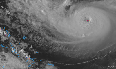
Now that we have the second strongest hurricane in the recorded meteorological history of the Atlantic-Gulf of Mexico-Carribean Sea region, I wanted to give you an update. Current Situation The storm now has sustained winds of 185 mph with gusts to 220 mph. One model has it producing waves of 70 feet! Below are images from the Nassau weather radar and GOES-16 weather satellite as of now. Any location experiencing this storm, at its current intensity, will experience destruction like that of a major tornado. See table below. Wind force is not  linear. The power of the wind increases disproportionately with its speed. Forecast The models are, unfortunately, nudging the path of the storm closer to the east coast of Florida and to the southeast coast in general. Here is the latest ECMWF model's forecast winds. This is an approximation and could shift a bit toward the east or the west. This forecast shows wind gusts of 50 mph or stronger across a vast area, not to men...

Hurricane Dorian: 5:10pm EDT, Friday

Image
4:59p image of Dorian. Dots are lightning bolts. Lightning near the eye of a hurricane is bad as it is a sign the storm is strengthening.  Here is the National Hurricane Center's new forecast along with my ongoing forecast (orange lines) of the path of the eye of Hurricane Dorian. Hurricane warnings are out for much of the Bahamas (red) Islands. The amber is the area now experiencing tropical storm-force winds and the brown is the area experiencing hurricane-force winds. The respective areas will increase a little in size as the storm intensifies. It is forecast to be a 140 mph storm, with gusts to 155 mph, at landfall. Wow. This storm will produce a deadly storm surge as well as highly destructive winds. Extensive flooding is likely. A least a few tornadoes are possible. You'll find my safety recommendations here . While you ponder those, please consider the thoughts below from Florida less than one year ago.

Hurricane Dorian: 9:35a Friday

Image
Dorian's winds are now 110 mph with a central barometric pressure of 972 millibars. Additional strengthening -- to Cat 4 wind speeds -- is forecast before landfall. A vicious storm surge is likely at landfall. When combined with higher than normal tides, it will likely be a devastating storm near where the center crosses the coast when the eye arrives Monday. As to the location of landfall, my forecast hasn't changed since yesterday: between Miami and Daytona Beach.  If you have friends/family in the threatened area, please pass this along to them. Here are the times by which you should have your preparations complete. click to enlarge Below is a rough  idea of the placement of the winds. Keep in mind this could shift north or south. Coastal buildings would be devastated due to the combination of winds and storm surge. The above is the latest forecast from the ECMWF model. If this were to be a perfect forecast, it would be one of, if not the costliest, disast...

Hurricane Dorian Update: 9:20pm Thursday

Image
I wanted to provide a complete update on Dorian  so you could hit the ground running in the morning.  Unfortunately, the storm is strengthening this evening. Pressure has dropped to 973 mb (it was 986 at 5pm) and it appears winds are now up to 95 mph (up from 85 mph at 5pm).  At 9pm, it is looking more organized on satellite than it did earlier in the day. So, the Hurricane Center's forecast of a Cat 4 hurricane striking Florida looks like it will be correct. As to where, here is their latest forecast. Here is their 5pm (latest) forecast (white). I have modified my landfall location forecast (red bars) slightly. The southern side remains at Miami. The northern edge has been moved south from St. Augustine to Daytona Beach. M = major hurricane. Tornadoes and severe flooding are also likely in Florida with the storm. The above is the NWS's rainfall amount forecast. However, I believe it is quite conservative. Some areas will receive 15" or more. I belie...

Hurricane Dorian, 5:50pm Thursday

Image
No reason for any updates as to my forecast (scroll down) or advice. Here is an updated rainfall forecast for the next seven days. Significant to major flooding is likely in Florida. The NWS is doing special balloon launches and aircraft recon at the present time and that data will be put into the evening models. Hopefully, tomorrow morning, we will have higher confidence in our forecasts.

11:30a Thursday, Hurricane Dorian

Image
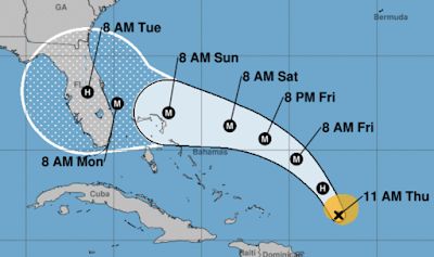
Here is the National Hurricane Center's latest forecast. M = Major Hurricane. The storm is forecast by NHC to have 130 mph sustained winds, with gusts to 150 mph, at landfall. My forecast for landfall, between Miami and St. Augustine, continues unchanged. It should be noted the two most reliable computer models forecast paths south of the NHC forecast. There is even a possibility the storm could reach Category 4 intensity. Here is the time by which you should have your preparations completed. Tornadoes and flooding are  likely.  The forecast total rainfall from now until 8am Thursday. Scroll down for my preparation recommendations. 

Hurricane Dorian: FYI...

Image
I was asked what the difference was between my forecast and the NHC forecast. The NHC forecast is within the thick white line. My forecast is between the red lines. If I lived between the red lines, I would be making preparations for Hurricane Dorian. If I were between the red and white lines, I would closely monitor the situation. What to do now? Given it is a holiday weekend, you may wish to consider getting out of Dodge before an official evacuation starts and roads become jammed. Close down the home (turn off electricity, water, board up windows, etc.) and go somewhere like Atlanta well out of harm's way. Make a reservation now. Let Mother Nature do her thing without you and your family harm's way.  If that is impractical, then I urge you to consider the following: If you want a generator,  have an electrician install it. If you decide on a portable generator, make sure to place it outside well away from any air intakes.  An automobile power inverte...

Hurricane Dorian Update: Wednesday, 5pm EDT

Image
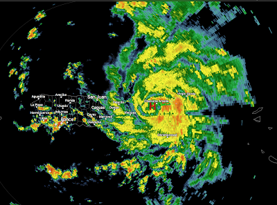
All of the reliable computer models place landfall of what is forecast to be major hurricane Dorian on the central or south Atlantic coast of Florida during the latter half of the Labor Day weekend.  It is still too soon to state exactly where on the coast landfall will occur. 4:45pm radar image of Dorian. Below is the National Hurricane Center's latest forecast. The outline represents the average error of their forecasts and they consider the entire area within the white outline to be at risk. click to enlarge My personal opinion is that the storm will make landfall between Miami and St. Augustine as a major  hurricane. Serious inland flooding is likely  to occur with this storm in many areas of Florida. Tornadoes are likely, as well. Here is the seven-day rainfall forecast. Here is the earliest reasonable time of arrival of sustained winds of 35 mph or higher. Excellent advice from meteorologist Brad Panovich. There is a significant chance Doria...

Hurricane Dorian, Update, 2:25pm Wednesday

Image
I strongly urge people living on or near the Florida east coast to begin preparations for a major hurricane late in the Labor Day weekend.  Dorian has officially been upgraded to hurricane status as of 2pm. Its wind is 75 mph sustained, with higher gusts, with a central barometric pressure of 997 millibars. The storm is getting better organized by the hour, unfortunately. At 2:02p, the developing eye of Dorian is east of Puerto Rico at the "H." It is moving WNW and likely will not pass directly over the PR which mean intensification can continue. With the latest model information, it is increasingly likely the landfall will be on the Florida Atlantic Coast. The latest ECMWF model, in my opinion the best hurricane model, is now more intense and slower than its most recent run. The image below is the latest ECMWF run, just in. Do not focus on its exact location . The eventual landfall could be hear or some miles to the north or south. There is a possibility it will ...