
Another Tornado Miss: South Carolina
A tornado struck the Myrtle Beach area this afternoon with no advance warning.


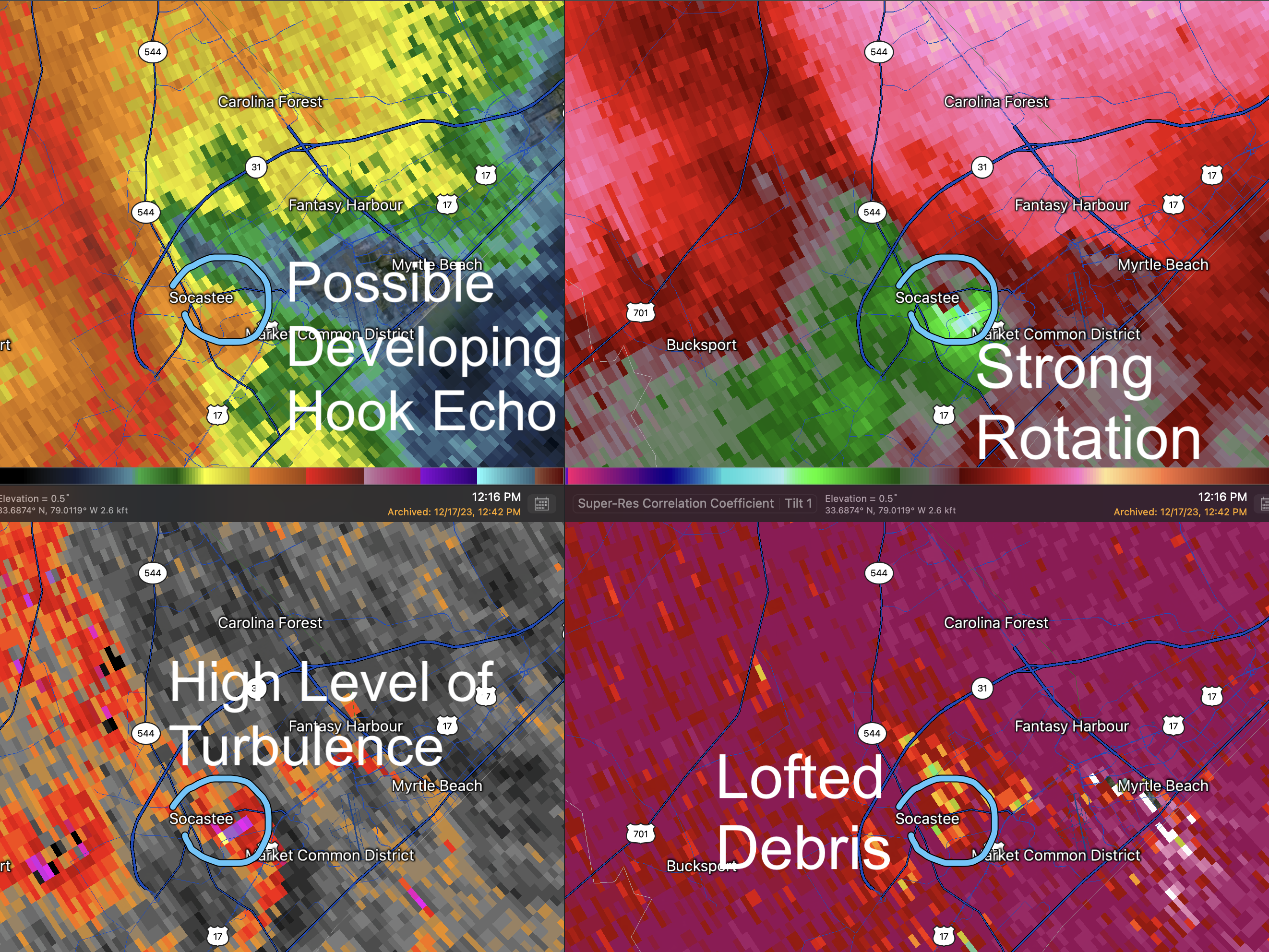
1:21pm, strong signature of lofted debris and strong rotation. 
 But, instead of saying "confirmed tornado" (which it was via the lofted debris), they say "radar indicated tornado" -- which social scientists tell us is less effective than using the term "confirmed."

 It is astounding to me that office after office in the National Weather Service keeps making these rather elementary mistakes.
While this was a tougher call than some, a tornado warning should have been issued at least seven minutes earlier than it was.
The Myrtle Beach area receives its storm warnings from the NWS in Wilmington, North Carolina, where the radar is located. With tornadoes possible, and a "mesoscale discussion" indicating tornadoes could occur, the radar should have been set to 80-second tornado SAILS mode. Instead, it was operating 180 seconds mode -- the mis-operation of the radar has occurred over and over again in these poorly warned tornado situations.
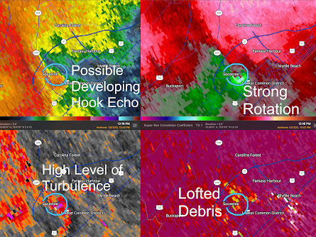
At 1:12pm, the radar clearly showed rotation (right panel, circled). However, I probably would not have warned at this point because the rotation was not particularly strong and the general atmospheric conditions for a tornado were relatively weak. Click to view full images.

At 1:15, I would have instantly issued a tornado warning had I been on the warning desk at WeatherData, Incorporated. The radar clearly shows one is present.
1:18pm, with still no tornado warning in effect, debris continues being lofted by the tornado with considerable rotation still visible.


At last, at 1:22pm, a tornado warning is issued.

The National Weather Service's lead-time (time interval between the warning and the tornado touching down) goal is +13 minutes. The NWS says the tornado touched down at 1:16pm, so that would make this lead time a -6 minutes.
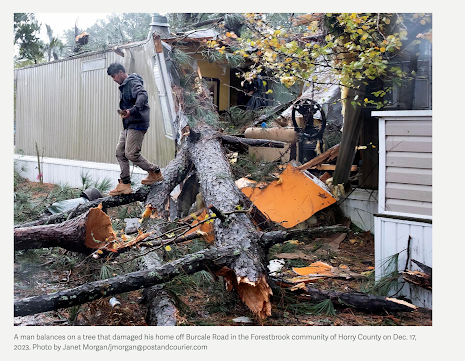
Fortunately, as far as I know, this was not a terribly violent tornado. Update Monday morning: The tornado has received a preliminary damage rating of EF-1.

 |
| Both photos: Scotty Powell |

It is all the more reason we need a Natural Disaster Review Board modeled after the highly successful National Transportation Board.


Hello Mike,
ReplyDeleteThe recurring theme of these misses in the warnings involve the Radar Mode, and waiting till there is "No Doubt" that tornadic activity is present. Why, when the SPC says conditions are favorable to Mesoscale Cyclones do they run the Radar in what appears to be non Sails Mode especially when the radar shown strengthening trends. Seeing this across many misses leads one to think that this is not a omissions due to experience, but a policy and or procedure.
I have read the paper showing the efficacy of the SAILS mode in the detection of tornadic as well as other hazards. It almost appears to be a bureaucratic edict to not be in this mode.
In the paper that discusses the SALES mode was this comment: "Thus, even though the perceived optimal VCP mode may vary over time, in this complex operational forecast and warning environment, the meteorologists’ heavy workload may prevent them from changing VCP modes frequently. Therefore, forecasters may tend to default to SAILS-off or SAILSx1 mode until an initial threat detection is made." This is from:
Impact of WSR-88D Intra-Volume Low-Level Scans on Severe Weather Warning Performance
Like you I am in firm agreement of a post incident debrief with an outside agency being the reviewers. Obviously, the service is not learning from or even acknowledging these issues and or complete failures.
Mike Smith
DeleteRichard, please help me out. I thought going into SAILS mode was a simple computer command. Am I incorrect? If so, what is involved?
DeleteAlso, there is a very good chance that "less is more" during tornado warnings. It may be some offices are making it unnecessarily complex.