
Posts

Showing posts with the label South Carolina

Heads Up: Carolinas

Image
In an abundance of caution, I wish to give a "heads up" to the Carolinas and southern Virginia due the possibility of the effects of Tropical Storm or Hurricane Imelda next week. This is a National Weather Service product showing the amount of rain forecast to fall over the next seven days.  In addition, if the forecast of a strong tropical storm or hurricane occurs in this area, there will be power outages.  The NWS seems agree with the potential in this situation. The hatched area below is where they are forecasting flooding potential next week.  This is a difficult forecast situation so this forecast may be off. However, since we are going into the weekend, it is important for everyone to know the potential for next week. 
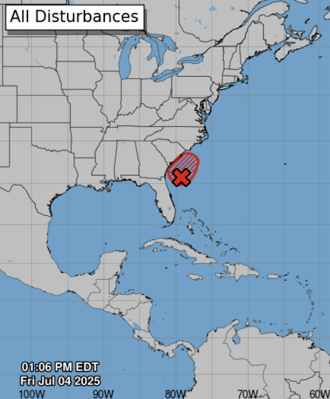
70% Chance of Tropical Depression Development

Image
There is a 70% chance of tropical depression or storm development in the next 48 hours in the area outlined in red. Please monitor the weather along the Georgia and South Carolina coasts through the holiday weekend. 

Southern Appalachians: Day 48 and It Is Still Worse Than You Can Imagine

Image
50 Days Ago: Hurricane Helene Develops in the Gulf of Mexico Helene's aftermath should be the lead story on each network's evening news for the foreseeable future.  Here's the latest on the horror in far east Tennessee, far northwest South Carolina, and western North Carolina: the situation is unbelievably bad and the people we pay to mitigate the effects of natural disasters are, at best, failing at their mission.  In the autumn of 2023, we had at least some reporting from the legacy media about the Maui "land grab" after the horrific fire that struck the City of Lahina. The historic city burned to the ground and the fire killed more than 100.  Serious questions remain unanswered about the Maui Wildfire, which is yet another reason why the United States must  create a National Disaster Review Board , see more below. But that is not the primary topic of this piece.  FEMA and insurance companies -- or people claiming to represent them -- have brought out that ...

10:05pm Forecast for Hurricane Debby

Image
As of 10pm, sustained winds of Tropical Storm Debby are 45 mph and the central pressure is 1003 millibars.  The highest sustained winds at landfall are forecast to be 85 mph. Extreme rainfalls with flash and river floods likely in northern Florida, Georgia and South Carolina. Flooding by occur in far southern North Carolina.  With the higher wind speeds, the storm surge heights have been adjusted upward.  This is a life-threatening storm surge forecast.  Tornadoes are possible Sunday and Sunday night in the green. 

6pm Update on Tropical Storm Debby - Hurricane Warning Issued

Image
 Below is the radar from 5:49pm. A center has formed and Debby is moving northwest. I have underlined Miami, Key West and Cape Coral to orient Florida. Red is a hurricane warning. Pink is a hurricane watch. Blue is a tropical storm warning. The amber area is the current area of tropical storm force winds (39-60 mph). S = tropical hurricane. H = hurricane.  Debby is only expected to move about 70 miles to northeast after 2pm Tuesday. That is why makes the potential rain event so dangerous.  The widespread 7 to 15" amounts near the coast will cause catastrophic flooding. Please prepare now! In addition a life-threatening storm surge of up to 7 feet is likely along the Florida Big Bend.  Finally, there is a significant risk of tornadoes Sunday and Sunday night in the green area. 

Tropical Storm Forecast for Florida - 5:30pm Friday

Image
The weak weather system now over Cuba is forecast to become Tropical Storm Debby off the coast from Naples Saturday evening. It is then forecast to move across Tampa with 60 mph winds (with gusts to 75 mph) and then curve northeast reaching the Jacksonville area by sunrise Monday. Blue = tropical storm warning and yellow = tropical storm watch.  Here is the storm surge forecast. Beyond Monday morning, the forecast becomes much more uncertain.  The models I trust the most have the system as a strong tropical storm from near Amelia Island to about Myrtle Beach. Then, they either move it inland or have it weaken near the South Carolina or North Carolina coasts. Vacationers to these areas should take the forecast for early next week into consideration.  The NWS is forecasting as much at 7" of rain (amber)in the coastal Carolinas (the yellow, 10" area, if off the coast.  I am forecasting a chance of tornadoes just about anywhere over the Florida Peninsula until the storm ...

Another Tornado Miss: South Carolina

Image
A tornado struck the Myrtle Beach area this afternoon with no advance warning. While this was a tougher call than some, a tornado warning should have been issued at least seven minutes earlier than it was.  The Myrtle Beach area receives its storm warnings from the NWS in Wilmington, North Carolina, where the radar is located. With tornadoes possible , and a " mesoscale discussion " indicating tornadoes could occur, the radar should have been set to 80-second tornado SAILS mode. Instead, it was operating 180 seconds mode -- the mis-operation of the radar has occurred over and over again in these poorly warned tornado situations.  At 1:12pm, the radar clearly showed rotation (right panel, circled). However, I probably would not have warned at this point because the rotation was not particularly strong and the general atmospheric conditions for a tornado were relatively weak. Click to view full images. At 1:15, I would have instantly issued a tornado warning had I been on the w...