
Update on Damaging Wind and Hail Threat Through Tonight
The NWS Storm Prediction Center has issued severe thunderstorm watches for the counties outlined in blue. They are in effect to 10pm local time. The radar data is from 3:48pm CDT. 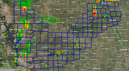 Generally, the forecast for areas within the watches:

- A Few Tornadoes
- Tennis Ball-Sized Hail
- Wind Gusts to 80 mph. Where those occur, power outages are likely.
With fire works displays scheduled for this evening, it will be important to keep up on trusted local weather information sources. Do not be reluctant to leave early if the weather appears to be threatening. Keep your smartphone charged and open to a quality source of weather info.
Have safe fun this evening!


Comments
Post a Comment