
Friday: 3:45pm CST Cold Wave Update
Forecast of the Cold Wave
Please make your friends and families aware of this forecast!
Two cold fronts will move across the United States in the next six days. We are going to focus on the second, which will be the leading edge of extremely cold air that will crash south across the nation.
6pm Tuesday

6am Friday, 23rd
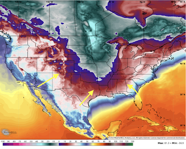
Below zero temperatures are forecast at that time as far south as the Texas Panhandle with spots in Wyoming and Montana as cold as -40°F. To be clear, we are talking about the air temperature and not the wind chill!

From there, the cold wave will move to the East Coast.
To get specific as far as low temperatures are concerned, here are the temperatures forecasted for 10am Thursday.
 |
| click to enlarge |
Wind chills at that same time (10a Thursday) are below:

At 6am EST on Friday, the cold wave is almost to the East Coast.

What Should I Do Now?
In addition to the dangers to health from the cold itself, there are several other issues:
- Bursting pipes
- Power failures
- Natural gas shortages
Here's how to mitigate some of the issues:
- Complete Christmas travel before the Siberian air arrives along your route and at your destination. If you are traveling by air, move up your departure.
- Get cash (ATM's don't work without power) and fill your car with fuel. Get important prescriptions refilled.
- Make sure you have "ice melt," sand or kitty litter to spread on driveways, sidewalks and porches for traction. It doesn't melt anything with temperatures of zero, but you will appreciate traction of you have snow and ice.
- If you have an infirm friend or relative who may need help, move them in with you before the cold air arrives.
- Public officials should make provisions for the homeless.
- Disconnect garden hoses!
- Do not use blow torches to unfreeze lines!
- Open the cabinets near where the water comes into the kitchen.
- Know where the water comes into your home and how to shut it off. If pipe(s) burst, turn off your water as quickly as possible.
- Keep your home's thermostat at the lowest possible level for your comfort to conserve energy. Wear sweaters and extra clothing. Use UL Lab-approved space heaters, if necessary.
 |
| National Weather Service |
Precipitation
I haven't said much about ice and snow because they are terribly difficult to forecast more than about three days out in this type of situation.
There is some possibility for light to moderate snows (1 to 5") in areas from eastern Kansas, across Missouri and into Iowa late Sunday into Monday. But, this is a low confidence forecast.
I'll have more on the ice/snow forecast later in the weekend.
Meteorological Discussion
I was shocked by some of the television meteorologists' forecast for late next week that I viewed at midday today: they were too warm, some by as much as 20°F. The models, as expected, are taking a long time to pick up on the shallow cold air that will move south but this morning's model run finally shows temperatures that look to be reasonable.
Because we are still six days from the coldest air reaching the middle of the nation, it is likely the models are still a bit too warm because they do not handle this type of shallow cold air well. For that reason, I am using the coldest of the major models (ICON, ECMWF, GEM and UKMET) for a given day.


Comments
Post a Comment