Posts

Showing posts with the label preparedness

Updated Winter Storm Forecast, 9:30pm CST

Image
--- This Forecast Has Been Updated  --- You Will Find the New Forecast Here After a quick look at the new data this evening, I believe the forecast is still good. There may be light amounts of freezing rain in north central Texas as far south as Waco. It will not be enough to cause power outages but -- if it occurs -- it will make roads very slick.  The snow amount forecasts haven't changed. I believe DFW will receive 1-3" with heavier amounts as you go northeast. I-30 will become a mess for its entire route.  --- original forecast still valid --- Here are the latest NWS winter weather warnings and watches as of 3:15pm Note: the white "hole" in southwest Texas will be filled in with a purple winter weather advisory for 1-3 inches of snow.  Color codes: Pink = winter storm warning  Dark green = winter storm watch Purple = winter weather advisory  Bright green = ongoing flood warning  Dark blue and bright turquoise = freeze warnings.  As expected, t...

Recommendations to President Trump Regarding FEMA

Image
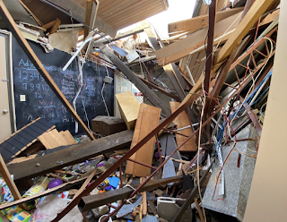
One of dozens of homes destroyed by the 2022 Andover, Kansas, Tornado If you missed yesterday's story about FEMA on Full Measure With Sharyl Attkisson , I encourage you to watch before reading further. You'll find the story here . It explains some of the many issues with FEMA's current operating model that -- literally -- have DEI and climate change ranking higher in FEMA's priorities than assisting disaster victims! If I were asked to give advice regarding the short- to medium-term future of FEMA, I would offer the advice listed below. The ultimate, and superior, advice would come from a National Disaster Review Board, but FEMA has become so dysfunctional that I don't believe the nation can afford to wait to make some or all of these changes.  The Advice The new mission of FEMA would be to serve as a facilitator to state and local governments in the wake of major (not routine) extreme weather and natural disasters (e.g., tsunami).  The current "boots on the gr...

4:50pm Hurricane Forecast

Image
Above is the latest forecast from the National Hurricane Center, but I have added all of the Tampa Metro area and coastal areas south to Sarasota to the forecast of possible paths of the storm's center.  It is important to consider that, if this is a perfect forecast or the storm moves a little to the east of the current path, there will be a significant storm surge in the Tampa Bay region.  Here is an explanation of the map.  M = major hurricane with winds to 115 mph.  H = hurricane. S = tropical storm.  Blue = tropical storm warnings Pink = hurricane watch Yellow = tropical storm watch  Assuming the forecast works out, the hurricane will be named Helene.  What would I do  now  if I lived in a coastal area with this storm potential?  Make sure infirm relatives and friends will be cared for.  Refill prescriptions.  Purchase any essentials. Fully fuel your auto and/or chain saw.  Make sure your "go kit" is up-to-date and re...

Hurricane Season 2024

Image
The Washington Post  Capital Weather Gang has a highly informative article about the forecasts for Hurricane Season 2024 . Those forecasts are alarming. Here's Colorado State's which is highly regarded: The forecasters quoted in the Post's  article are known to be quality forecasters with fine track records (as mentioned before, I am not a long range forecaster of hurricanes or any other weather phenomena).  What do I suggest? Have your hurricane preparations finished by May 15, or even May 1, this year. This includes preparing to assemble a "go kit" in case your area is put under an evacuation order. I post a list so I list so don't forget something important in the last minute haste. One of the items in a go kit is cash. To the extent your means will allow, draw out some extra cash and put it in your wallet or purse. Purchase a quality paper map of the region. There are times when the interstate highways are clogged but traffic on state highways is fluid.  B...

Tornado Safety Advice for Mobile Home Residents

Image
Mobile homes are not safe in a tornado.  Your life may well depend on executing your  tornado safety plan when storms approach.  If you live in a mobile home, I recommend elevating the importance of tornado watches  -- the forecast that tornadoes may occur the next few hours. When a tornado watch is issued for your area, it is time to begin monitoring the weather closely. If you have an official shelter available to you that you can reach in a matter of tens of seconds, you are good to go, provide you have a way to immediately receiving warnings.  If you have to go to a friend's house, community shelter, or other shelter that requires minutes to get to, I recommend heading that way if a severe thunderstorm warning is issued or if there is a tornado warning on a nearby storm that hasn't yet reached your area. 

Tornado Warning Advice For Businesses

Image
This is excellent advice for employers. If you have on-site daycare, I recommend diapers for the shelter area.  However,  there are four missing items: A way to instantly  notify employees.  Don't have employees monitoring radar or making sheltering decisions.  Have a commercial weather company that specializes in extreme weather warnings.  Make sure you can still speak to customers from the shelter area. If your business is in the path or possible path of a tornado, you need to instantly notify your employees. Do you have one? Will all  of your employees recognize it? Security guards and risk management professionals play a critical role in modern business. But, they do not have the specialized knowledge and experience to second-guess meteorologists. If you are using National Weather Service warnings, go to shelter if your business is in the polygon, as below. If you have a small business with minimal shut-down costs, the NWS polygon is a good way to ...

EXTREMELY IMPORTANT: COLD WAVE HEADED SOUTH

Image
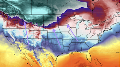
Please read this. Make sure family and friends are aware if you live east of the Rockies. The pending cold wave may be more disastrous  than a hurricane.  Three years ago, in February, 2021, this blog published the following warning: Tragically, the cold wave was as bad as forecast and between 200 and 700 people perished. An Austin friend of mine told me about a family down the street that burned down their home in a desperate attempt to stay warm after the electricity was out for two days (they had electrical heat).  This Cold Wave May Be Worse Than 2021's Below is the current 6-10 day outlook. "Below normal" doesn't quite convey how cold it may be. I'll provide specific temperatures below.And, what could make this worse, is that the Central United States is more dependent on wind power than it was three years ago. The utter failure of wind power in Texas (dropped to 1% of capacity at one point) was one of the primary reasons for the catastrophic loss of electric...

Next Week's Major Storm, Updated 5:20pm CST

Image
A major winter storm will affect the United States next week and it is likely to complete the meteorological pattern change: not only will we will see snow, the coldest air of the season is likely to move south from Canada and the Arctic. For businesses, preparations will be important.  Update at bottom.  The Pending Cold Wave Before we discuss the snow, here is a forecast temperature map for Friday morning. Greenish colors are temperatures below zero.  Please keep in mind these are temperatures and not wind chills.  Next Week's Snow We've already posted on snow Storm #1 in central U.S. here , and in the Northeast, here .  The forecasts below pertain to Storm #2.  The first area where we expect problems is along Interstate 80 over the Sierra where amounts of 16 to 22 inches are forecast to fall.  The storm will tap moisture from the Gulf of Mexico and cause a band of heavy snow from the central Great Plains toward the Great Lakes.  Once the accumu...

Heavy Snow Reminder

Image
With Thanksgiving travel upon us and the likelihood of a large area of snow falling after Thursday, a reminder is timely.  For Winter Storm Warnings Here is a very  preliminary forecast of snow Friday-Saturday-Sunday next weekend. South of about I-80, this snow, if it falls, would be early in the season. Shoveling would be necessary in some areas. Some of the models have (light) snow as far south as I-40 in Oklahoma, including OKC and Tulsa. Please consider this as it pertains to your travel plans. 

Attention: Teachers and School Administrators

Image
The American Meteorological Society has assembled an outstanding list of resources for weather, natural hazard, and general emergency resources . I highly recommend it as you plan for the 2023-2024 school year. 

Saving Lives in Tornadoes

Image
The National Weather Service has published an informative story about how the staff of a daycare center in Selma, Alabama, saved the lives of their students in a tornado this past January 12. The story is here .  The radar looked like this just before the tornado struck.  Successful results in tornado situations are a team effort: meteorologists, broadcasters and the people in the path. It was very wise that the staff moved everyone into the bathrooms rather than the hallways. If you don't have a basement, the best place to be is on the lowest floor in a small room such as a closet or bath. Getting into the bathtub is a good idea. If you own a football helmet, wear it. We've had a few days without significant tornadoes. Things will be picking up again soon. Please make sure you are prepared. 

Friday: 3:45pm CST Cold Wave Update

Image
Forecast of the Cold Wave Please make your friends and families aware of this forecast! Two cold fronts will move across the United States in the next six days. We are going to focus on the second, which will be the leading edge of extremely cold air that will crash south across the nation.  6pm Tuesday The leading edge of the Siberian air is indicated by the arrows. Where the blue transitions to light green is the zero temperature line.  6am Friday, 23rd From there, the cold wave will move to the East Coast. To get specific as far as low temperatures are concerned, here are the temperatures forecasted for 10am Thursday. click to enlarge Below zero temperatures are forecast at that time as far south as the Texas Panhandle with spots in Wyoming and Montana as cold as -40°F. To be clear, we are talking about the air temperature and not the wind chill! Wind chills at that same time (10a Thursday) are below: There are a number of areas with wind chills of -50°F or colder with -30°...

Tornadoes Possible Early Next Week

Image
The severe thunderstorm "scoreboard" as of this morning. The National Weather Service has an experimental long-term forecast system for severe thunderstorms and tornadoes. It is lighting up for early next week from the central Great Plains to the northern Plains and Upper Midwest.  Now is a perfect time to sign up for StormWarn -- the first true " tornado alarm " which will notify you instantly when it is take to go to your storm shelter, even if it is the middle of the night. For about $2 a month, you give your family peace of mind plus you no longer have to stay up late at night monitoring the weather. It is a bargain! September is National Preparedness Month. Make sure your family is prepared with StormWarn. 

Global Warming Is Not Needed to Produce a California Megaflood

Image
Big Climate is cranking out the press releases as they vie for the big dollars from President Biden's climate bill. The latest generated headlines about a $1 Trillion flood in California made possible by global warming.  There is a genuine threat of a trillion dollar flood in California and it isn't necessary for global warming to play a role. I wrote about this  threat on November 5 of last year after reading a historical article in Scientific American.  All that has been done by the UCLA researchers is to take the 1862 disaster and superimpose it on today's dense population and huge growth of wealth in the state. As to the increasing temperatures causing heavier rates of rain in California, that is the result of a computer model and there is hardly enough data to confirm this is truly the case.  The study is useful as an exercise as to which areas of the state are most vulnerable when the next megaflood occurs. Plus, I continue to worry that there is far too littl...

Tornado Drought: Ten Years Since the Last Major Tornado Outbreak in Tornado Alley

Image
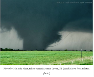
Ten years ago yesterday, strong tornadoes roamed the Great Plains. The photo below is from my blog post ten years ago today . This is a map of the paths of the tornadoes.  The Tornado Outbreak of April 14, 2011.  Red = tornado. Blue = damaging thunderstorm wind. Green = large hail. Yesterday was the tenth anniversary of the last major tornado outbreak in the area we traditionally label "Tornado Alley." Of course, the reality is that the peak tornado alley moves through the decades .  But, even stipulating that tornado alley moves, it is extremely unusual that we have had such a drought of major tornadoes of this duration and I am concerned that a number of us have forgotten how to prepare for a high or extreme-risk tornado situation. For reminders, please go here and scroll down. It is vital that we residents of the Great Plains not let down our guard. As the situation Tuesday in Texas and Iowa demonstrated, strong tornadoes will occur again and the tornado drought will ...

Next Week: Tornado Threat in Traditional Tornado Alley

Image
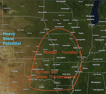
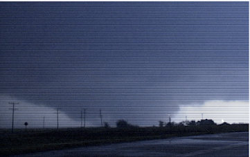
Usually, I don't do tornado forecasts 4+ days in advance. However, after three years of a record and near-record "tornado drought" in traditional Tornado Alley, I want to make sure everyone is prepared. The Forecast For the first time in years, we have a multi-day tornado and severe thunderstorm threat in the area outlined in red. This does not mean that every area, every day, will see tornadoes.  It means that there will be multiple rounds of severe thunderstorms during the four-day period. Note also that in the High Plains heavy snow is a possibility. It is not possible, this early, to try to narrow down the threat more specifically than this. I will, of course, provide more specificity as we get closer to the event.  Recommendations Schools: If you haven't already tomorrow would be a good day to do a tornado drill. Make sure everyone is familiar with tornado procedures and ways to protecting everyone involved. Business: See above, plus make sure you have ways of in...

Today's Managerial Resolution: An Effective Tornado Plan!

Image
Photos by Dick McGowan The tornadoes of Friday night emphasize the absolute necessity for businesses to have an effective plan to protect their employees when a tornado threatens.  Your shelter should be able to protect your team against debris flying at more than 150 mph! There are three elements to creating an effective response for tornadoes: ·       Advance planning . Where will your people shelter? Does it have enough space? How will your people get word that a tornado is approaching? ·       A commercial weather company that will give you enough time to get everyone sheltered and accounted for (National Weather Service warnings are not suitable for this purpose). Procedures as to whom is responsible for sounding the alarm, 24/7. ·      After the storm . If the worst happens, how do you get help to your employees and coordinate the post-storm response? Effective advance pl...

Inflation: You Ain't Seen Nothing Yet!

Image
With today's report of inflation at more than 6% (worst in 30 years), please consider it the beginning and not the end. Here is the bottom line :  ... it’s not yet winter.  As temperatures decrease, corporations and households will consume even more energy,  increasing demand. Winter heating is not an optional cost. One cant allow one’s family and/or employees to freeze. The increase in consumption of energy during the winter will raise prices even higher.- That’s only part of the story. The higher energy prices and the need to keep indoor temperatures warm will raise the cost of producing products.  The increase in energy costs will also raise the price of the supply chain—an increase in the fuel costs for trucks, container ships, etc. Companies will not eat those higher prices. The costs of producing and shipping products will force companies to increase the price of their goods. Put it all together, as the weather gets colder,  energy costs will rise even fas...

Preparing for Disasters

Image
A  USA Today  article correctly cites that the USA is critically unprepared for "low probability/high impact" events. I'm surprised they didn't include Texas' cold wave catastrophe in the article.  While the article includes many truisms, its overall point is clearly correct. Both governments and the private sector are inadequately prepared for manmade and natural disasters. 

NOW is the Time to Create a Preparedness Supply

Image
I don't know if the intelligence community in Washington has picked up on something, or is just extrapolating from the recent Colonial Pipeline terrorist shutdown , but the flurry of articles on the subject of electrical system terrorism continue .  Plus, there is nothing we can do to stop a solar storm from attacking earth.  It is almost impossible to overstate the catastrophe -- far worse than the COVID shortages or last week's gasoline shortages -- that would exist if our electricity was shut off in a large geographic area for any significant amount of time. Possible examples: Stores quickly run out of goods -- including grocery and drug stores Water supplies, at best, are limited.  Hospital generators run out of fuel.  Cell towers and telephone systems fail a few days into the crisis.   That is why I urge my readers to stock up on essentials in a way that could sustain them for at least  two weeks. We have a longer-duration supply in our home. We rotat...