Posts

Showing posts with the label 2022 cold wave

Wyoming and Kansas Report In: Wind Energy Collapsed During Cold Wave
Image
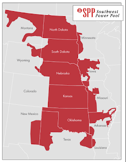
This report from Wyoming on its near blackout during the recent cold wave and winter storm.  Lee Boughey, a spokesperson for Tri-State Electric Generation and Transmission Association, said the nonprofit, which provides power to eight electric cooperatives across Wyoming, planned for the impacts of the storm as it approached.  They anticipated higher demand from member utilities in Colorado, Nebraska and Wyoming, and Tri-State prepared for wind energy resources to decline.  For safety, during extremely high winds, wind turbines will stop running and feather their blades. Icing also can cause turbines to stop running.  According to energy mix data from the Southwest Power Pool, as the storm began to move through Wyoming on Dec. 23, at 3 p.m., wind energy resources began to drop. Within 24 hours, wind energy resources were about 25% what they were prior to the storm.  They didn’t begin to rise again until Christmas morning.  To compensate for the decline i...
"Unforeseen Storm"? You're Kidding, Right?!

Image
"That's our story and we're sticking to it!" seems to be Southwest's (SWA) strategy of blaming "unforeseen weather" for their operational meltdowns.  I've often written about weather being the "all-purpose excuse" when businesses fail their customers or fail to meet organizational goals. But, Southwest's continuing to offer weather as an excuse for their current meltdown is particularly egregious.  This is my first forecast of the storm and cold wave back on December 8 . There was more on December 9 . To conclude the December 9 forecast, I wrote: The first forecast with detailed timing and extent of the event was December 12 . This forecast was amazingly accurate considering the event didn't begin until the 22nd. You can roll the blog back and see the extremely detailed forecasts between the 12th and 22nd. I believe you will be impressed. SWA has an internal meteorology department. It is unthinkable they missed this event. If I were...

It Isn't a Mystery: The Culprit is [Lack of] Wind Energy...

Image
...and, to a lesser extent, solar; along with the recent phenomenon of electrical "marketers" who are not in the utility industry.  Texas is the #1 state for wind energy. When it fails, as it did Saturday, they are in serious trouble as they were during the Valentine's Day energy catastrophe is 2021. Midday Saturday, wind energy dropped to less than 3% of capacity in the Lone Star State. Texas has its own power grid. Nashville and Tennessee are served by the federal government's Tennessee Valley Authority (TVA). The problem there is that temperatures were unusually cold over the eastern power grid. In Kansas Saturday (#2 state for wind), the winds were nearly calm. The same was true in nearby sections of Nebraska and Oklahoma. There just wasn't any power to send east.  Map of the three grids that serve North America When you combine that with the "power marketers" (people who sell power without the backing of physical resources), you have a recipe for di...

Modern Meteorology -- A Vital, But Underused, Tool

Image
The economic loss and human casualties from the major storm and cold wave now winding down are still to be totaled, there is no question that they are much lower than they would have been 150 years ago before the science of meteorology began.  The conditions with this storm -- extremely cold air with a rapid drop in temperature -- have, in the past, resulted in horrendous loss of lives. For example, "The Children's Blizzard" of 1888 took a stunning 235 lives. The snow amounts in the Great Plains in '88 were not that great -- the maximum was just six inches. But the extreme cold and high winds combined with greatly reduced visibility caused the children to become lost. There were thousands of children walking home from school at the time and they were caught, unaware, in those extreme conditions. Many died from exposure.  That was certainly not the case with this storm. I made my first post about the cold wave on this blog on December 8 , 13 days before the start of th...

9:50am CST Winter Storm Update

Image
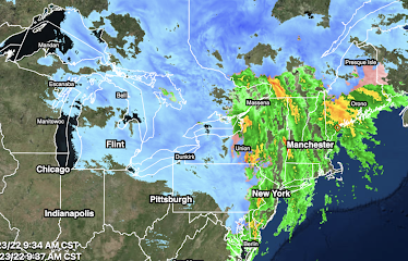
The major storm is causing havoc to transportation and to the general public as it has moved east. High winds are occurring throughout New England. Burlington has recorded a gust to 70 mph, the second highest gust ever recorded at that weather station.  A map of the current power outages is below. I have gone to the FAA's web site and it should be assumed that all of the areas showing rain or snow on the radar have significant delays. Of course, these delays cascade through the system. If you are trying to fly today, I would urge you to go online (don't try to call) and check the status of your flight. According to the news media, 3,000 flights have been cancelled.  The West isn't without troubles.  Because of the mountains, the radar algorithm is having issues with precipitation type in Washington. There are more areas that are receiving freezing rain (pink/orange) than shown. There are power outages as a result.  Finally, there are areas of snow and rain in the Sou...

Almost Certain Damage to 2023 Wheat Crop

Image
-- 2023 Wheat Crop Takes Another Hit -- This is where hard red winter wheat is grown  in the USA. The extreme cold likely damaged this year's crop. Mid-Afternoon Weather Satellite Image Amarillo, TX reached -1°F this morning, Dalhart was zero; Boise City (OK) reached -4°F. All of these locations had no snow cover as shown on the above weather satellite image from this afternoon. It will be extremely cold tonight as the forecast map (below) which depicts 4am temperatures, indicates. I am seriously concerned about damage to the 2023 winter wheat crop crop in the southern High Plains. The wheat is planted in September and early October and is harvested the following late May to July. Usually, wheat can survive extreme low temperatures if  it is covered by snow. This was not the case today nor will it be the case tonight. Combine it with the drought (below) and I believe yields will take a huge hit.  Palmer Drought Index The browns and red = drought. The blues = wet condition...

4pm Winter Storm, Cold Wave, and Airport Delay Update

Image
Temperatures as of 3pm CST Forecast Temperatures as of 9pm CST Forecast Temperatures as of 8am CST Friday  Forecast Temperatures as of 5pm CST Friday Average Airport Delays and Closures as of 3:50pm CST NYC -LaGuardia: 1 hour, 22 minutes NYC - JFK:  2 hours, 10 minutes Reagan - Washington:  33 minutes  Chicago - O'Hare:  2 hours, 20 minutes  Philadelphia:  18 minutes  Toronto:  36 minutes  Sioux Falls - Airport closed due to blizzard. The FAA is monitoring Memphis, DFW and Louisville for possible delay program implementation.  Go online and check with your airline before going to the airport.  Radar as of 3:44pm CST.  Forecast Radar as of 9pm CST Darker blues mean heavier falling snow. Winds will be increasing in the Northeast which means blizzard conditions. The pinks and oranges are icy conditions.  Forecast Radar as of 8am CST Friday Forecast Radar as of 5pm CST Friday With the exception of eastern New England, the...

Ground Blizzard

Image
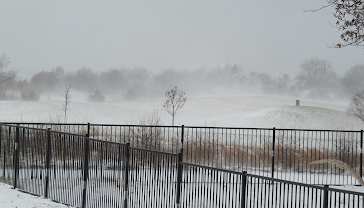
These two photos represent what meteorologists call a "ground blizzard."  It is not  snowing at my home. In fact, we had a few moments a sun a little while ago. However, the high winds (gusting to 47 mph) are lifting up the snow. If you were inside one of these thicker areas of snow, the visibility would be greatly reduced, so you would need to slow down to be save.  Video of ground blizzard conditions below. Note: I'm taking a break the rest of the afternoon. Scroll down one post for my latest forecasts. 

11:40am Complete Winter Storm Forecast

Image
Let's begin with temperatures. 10am Temperatures  3pm Forecasted Temperatures 9pm Forecasted Temperatures 3am Friday Forecast Temperatures I included this because it is when single digit temperatures reach the Rio Grande River. Forecast wind chills are immediately below. By this time, wind chills will have dropped to zero or below along the Rio Grande and will continue to fall the rest of the morning. This will create a humanitarian crisis due to the huge number of people outdoors and exposed to the extreme cold. Precipitation  Here is the current radar as of 11:32am CST. The NWS is predicting snow squalls with blizzard conditions between now and 4pm in the outlined area. Forecast Radar for 4pm CST. The darker the blue, the heavier the snow. Chicago's O'Hare and Midway Airports will be seeing major cancellations in addition to the major delays now occurring. Some areas in the Midwest will be experiencing blizzard conditions.  The snow in Pennsylvania will move into Ups...