
C'mon, National Weather Service (Modified)
Why isn't a blizzard watch in effect in South Dakota?
It turns out that is a valid question, but it was posed to the wrong people. I apologize to the NWS in Rapid City.
It turns out that National Weather Service headquarters eliminated the blizzard watch product as part of a (my opinion) misguided product "simplification."

So, the NWS in Rapid City could not have issued a blizzard watch.
I was also misled by the blizzard watch still being in the product list at Pivotal Weather (below) and by the fact it is still listed at Wikipedia.

I wish to thank Jon Porter of AccuWeather for providing me with the correct info.
The National Weather Service office in Rapid City, SD, which has forecast responsibility for the southwest part of that state, wrote at 2:25pm MST:Okay, fine. The Rapid City NWS is expecting a crippling blizzard. I agree with every word of this. But, why doesn't their forecast match their words?! If they believe a major blizzard is going to occur, why haven't they issued a blizzard watch or blizzard warning?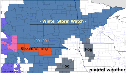
Instead, there is a vast "winter storm watch" that is rather uninformative. For example, in Minnesota, the winter storm watch is for freezing rain and ice conditions. In South Dakota, it means blizzard. In Montana, it means just a couple of inches of snow.
The NWS in Cheyenne has issued a blizzard warning (orange) and a winter storm warning (pink).
The NWS's own "impact index" (below) says, "expect considerable disruption to daily life." The values in SD are the same as in the blizzard warning area. 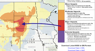
I cannot think of a single reason why adjacent parts of western South Dakota are not under a blizzard watch or warning, except for the inconsistency between NWS offices -- which is a lousy reason. People need time to plan for a storm of this power. A glance that the forecast map doesn't provide the "pay attention!" message it needs to provide, especially since different preparations are needed for ice versus a blizzard.
That is an advantage of using a service like AccuWeather: consistency.
But, the NWS can and should do better than this when a major threat to safety and economic loss exists.
Do better, National Weather Service!
NWS headquarters needs rethink the blizzard watch. I also believe it needs to add an "ice storm watch."
[original text below]
Confidence in heavy snow and [high] wind very high...this would support blizzard conditions.Snow amounts...on the South Dakota plains should be in the 10-20 inch range, with 6-12 inches possible from NE Wyoming into NW South Dakota. 12-24+ inches are still possible in the northern Black Hills and northern foothills. [the 24+" refers to total snowfall, not to drifting]


Comments
Post a Comment